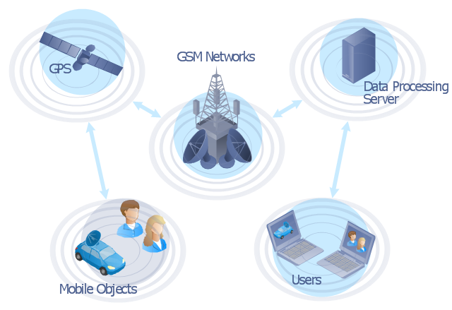
"The Global Positioning System (GPS) is a space-based satellite navigation system that provides location and time information in all weather conditions, anywhere on or near the Earth where there is an unobstructed line of sight to four or more GPS satellites. The system provides critical capabilities to military, civil and commercial users around the world. It is maintained by the United States government and is freely accessible to anyone with a GPS receiver." [Global Positioning System. Wikipedia]
This GPS operation diagram example was created using the ConceptDraw PRO diagramming and vector drawing software extended with the Telecommunication Network Diagrams solution from the Computer and Networks area of ConceptDraw Solution Park.
This GPS operation diagram example was created using the ConceptDraw PRO diagramming and vector drawing software extended with the Telecommunication Network Diagrams solution from the Computer and Networks area of ConceptDraw Solution Park.
GPS network diagram
 Telecommunication Network Diagrams
Telecommunication Network Diagrams solution extends ConceptDraw DIAGRAM software with samples, templates, and great collection of vector stencils to help the specialists in a field of networks and telecommunications, as well as other users to create Computer systems networking and Telecommunication network diagrams for various fields, to organize the work of call centers, to design the GPRS networks and GPS navigational systems, mobile, satellite and hybrid communication networks, to construct the mobile TV networks and wireless broadband networks.
Network Diagram Software


Network Diagram Examples
Network Drawing Software
Network Diagram Software
 Computer and Networks Area
The solutions from Computer and Networks Area of ConceptDraw Solution Park collect samples, templates and vector stencils libraries for drawing computer and network diagrams, schemes and technical drawings.
- GPS operation diagram | Network Diagram Software (PRO ...
- GPS operation diagram
- Automatic vehicle location | GPS operation diagram | Automatic ...
- GPS operation diagram | Computers and network isometric - Vector ...
- GPS operation diagram | Telecommunication Network Diagrams ...
- GPS operation diagram | Components of ER Diagram | Network ...
- Telecommunication Network Diagrams | GPS operation diagram ...
- GPS operation diagram | Network Diagram Software | Independent ...
- GPS operation diagram | Mobile satellite TV network diagram | Bar ...
- Basic Flowchart Symbols and Meaning | Network Diagrams for ...
- GPS operation diagram
- GPS operation diagram
- Operation Of Satellite Network With Diagram
- GPS operation diagram | Gps Diagram Waves
- Telecommunication Network Diagrams | GPS operation diagram ...
- GPS operation diagram | Aerospace and Transport | Diagram Of ...
- Telecom equipment - Vector stencils library | Entity-Relationship ...
- Flowchart Diagram Of Gps
- GPS operation diagram | Pyramid Diagram and Pyramid Chart ...
- GPS operation diagram | Positioning Of Vehicles