Geo Map — United States of America Map

HelpDesk
How to Convert a Mind Map into MS Word Document

HelpDesk
How to Draw Maps of Australia

HelpDesk
How to Input Data from MS Excel Into a Mind Map

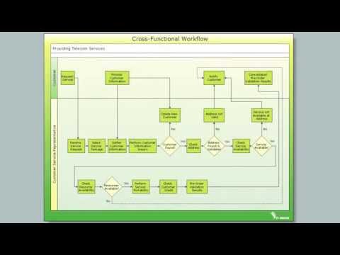
Cross-Functional Flowchart

 IDEF0 Diagrams
IDEF0 Diagrams visualize system models using the Integration Definition for Function Modeling (IDEF) methodology. Use them for analysis, development and integration of information and software systems, and business process modelling.
Geo Map - Africa - Guinea Bissau

Geo Map - Africa - Guinea

Geo Map - World

Geo Map of Americas

Geo Map - Australia - Victoria

Geo Map - Africa - Senegal

Geo Map - South America - Mexico

Geo Map - Africa - Ghana

Geo Map - Africa - Malawi

- South America - Vector stencils library | América Do Sul Mapa Png
- Icon Mapa Png Ios 9
- Mapa Israel Vector Png
- Geo Map - Europe - Russia | Png India Mapa
- Geo Map - United States of America Map | Mapa De Sudamerica ...
- Mapa Png Vector
- Icone Mapa App Png
- Mapa De Angola Png
- Mapa Guzana Png
- Mapa Angola Vector Png
- Argentina Mapa
- Mapa Argentina Brasil Uruguay Paraguay Png
- Mapa America Png
- Latin America - Vector stencils library | Geo Map - South America ...
- Geo Map - South America - Colombia | Latin America - Vector ...
- South America - Vector stencils library | Geo Map - South America ...
- Geo Map - Africa - Angola | Africa - Vector stencils library | Geo Map ...
- Guyana Map Png
- Paraguay Map Png
- America Vectores Png