Geo Map - Africa - Zimbabwe

Geo Map - Africa - Namibia

Geo Map - USA - Michigan

Geo Map - Africa

The vector stencils library "Education maps" contains 44 map contours: the Group of Twenty (G20) state maps, EU state maps and world map.
Use it to visualize geospatial information on thematic maps in your education infograms.
"A world map is a map of most or all of the surface of the Earth. ...
A thematic map shows geographic information about one or a few focused subjects." [World map. Wikipedia]
The political World map example "Design elements - Education maps (World map)" was created using the ConceptDraw PRO diagramming and vector drawing software extended with the Education Infographics solition from the area "Business Infographics" in ConceptDraw Solution Park.
World map
.png--diagram-flowchart-example.png)
The vector stencils library "Management maps" contains 44 map contours: G-20 state maps, EU state maps and world map.
Use it to create your management infogram in the ConceptDraw PRO diagramming and vector drawing software.
The state map contours example "Management maps - Vector stencils library" is included in the solution "Marketing infographics" from the "Business infographics" area of ConceptDraw Solution Park.
World map

Argentina

Australia

Austria

Belgium

Brazil

Bulgaria

Canada

China

Croatia

Cyprus

Czech Republic

Denmark

Estonia

Finland

France

Germany

Greece

Hungary

Indonesia

India

Ireland

Italy

Latvia

Japan

Lithuania

Luxembourg

Malta

Mexico

Poland

Portugal

Romania

Russia

Saudi Arabia

Slovakia

Slovenia

South Africa

South Korea

Spain

Sweden

The Netherlands

Turkey

United Kingdom

United States

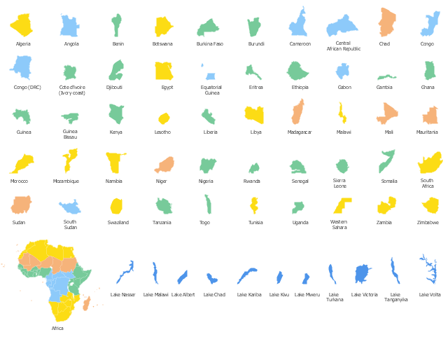
Use the map contours library Africa to design thematic maps of African countries using the ConceptDraw PRO diagramming and vector drawing software.
The design elements library Africa contains 122 African state map contours, Africa political map and biggest lakes contours.
The vector stencils library "Africa" is included in the Continent Maps solution from the Maps area of ConceptDraw Solution Park.
The design elements library Africa contains 122 African state map contours, Africa political map and biggest lakes contours.
The vector stencils library "Africa" is included in the Continent Maps solution from the Maps area of ConceptDraw Solution Park.
African countries map contours
Geo Map - Africa - Zambia

Geo Map - Africa - Mozambique

Geo Map - Africa - South Africa

Geo Map - Africa - Sierra Leone

"East Africa or Eastern Africa is the easterly region of the African continent, variably defined by geography or geopolitics. In the UN scheme of geographic regions, 20 territories constitute Eastern Africa:
- Tanzania, Kenya, Uganda, Rwanda and Burundi – in Southeast Africa included in the African Great Lakes region and are members of the East African Community (EAC). Burundi and Rwanda are sometimes considered part of Central Africa.
- Djibouti, Eritrea, Ethiopia and Somalia – collectively known as the Horn of Africa.
- Mozambique and Madagascar – often considered part of Southern Africa. Madagascar has close cultural ties to Southeast Asia and the islands of the Indian Ocean.
- Malawi, Zambia and Zimbabwe – often included in Southern Africa, and formerly of the Central African Federation.
- Comoros, Mauritius and Seychelles – small island nations in the Indian Ocean.
- Réunion and Mayotte – French overseas territories also in the Indian Ocean.
- South Sudan – newly independent from Sudan." [East Africa. Wikipedia]
South Sudan has become independent on July 9, 2011. Sudan and South Sudan are shown with the new international border between them.
This East Africa political map was redesigned using the ConceptDraw PRO diagrammin and vector drawing software from the Wikimedia Commons file: Afryka Wschodnia.png.
[commons.wikimedia.org/ wiki/ File:Afryka_ Wschodnia.png]
The example "East Africa - Political map" is included in the Continent Maps solution from the Maps area of ConceptDraw Solution Park.
Political map - East Africa

Geo Map - Africa - Uganda

Geo Map - Africa - Cameroon

Geo Map - Africa - Congo DRC

- Geo Map - Africa - Zimbabwe
- Geo Map - Africa - Zimbabwe | Geo Map - Africa - Morocco | Draw A ...
- Geo Map - Africa - Zimbabwe
- Geo Map - Africa - Zimbabwe | Geo Map - USA - Michigan | Geo Map ...
- Nigerian Map Clip Art Png
- Nigeria Vector Map
- Geo Map - Africa - Namibia | Geo Map - Africa - Zimbabwe | Geo ...
- Drawings Of South Africa Zimbabwe Tanzania Flag
- Botswana Map Of Africa
- Design elements - Africa flags | Geo Map - Africa - Morocco | Design ...
- Black Namibian Map Png
- Design elements - Africa flags | Geo Map - South America Continent ...
- Geo Map - USA - Michigan
- Design elements - Africa flags | Africa flags - Stencils library | Geo ...
- Design elements - African country flags | Geo Map - Africa - Zambia ...
- Geo Map - Africa - Nigeria | West Africa countries | Africa - Vector ...
- Africa Contour Map
- Drawing Of Somalia Map
- Drawing Of Ghana Map
- Geo Map - Africa | Map of the African Union with Suspended States ...