This site uses cookies. By continuing to browse the ConceptDraw site you are agreeing to our Use of Site Cookies.

Geo Map — South America Continent

South America includes 12 sovereign states.
ConceptDraw DIAGRAM is idea to draw the geological maps of South America continent from the pre-designed vector geo map shapes.
Use Continent Maps solution from the Maps area of ConceptDraw Solution Park to draw thematic maps, geospatial infographics and vector illustrations for your business documents, presentations and websites.
HelpDesk

How to Draw a Map of North America

Geographic maps, cardiograms, and thematic maps are often used for geographical visualization of business information. Any country can inspire a wealth of geopolitical statistical data. A common way of assimilating this data is to create maps that convey a particular theme or subject matter in relation to a specific geographical area. Known as thematic maps, they cover themes such as population density, average rainfall, or political allegiance, differentiating the data by using graphical elements and annotation. Thematic maps contrast general reference maps, which tend to display information on a variety of subjects — vegetation, topology, roads, and highways, for example. A thematic map will always focus on one particular subject matter. ConceptDraw DIAGRAM can be helpful as a tool for creating maps of countries and regions of the world. It allows you to draw continental maps quickly and easily using the special templates and vector stencils libraries.

Geo Map - South America - Chile

Chile, officially the Republic of Chile, is a South American country occupying a long, narrow strip of land between the Andes mountains to the east and the Pacific Ocean to the west.
The vector stencils library Chile contains contours for ConceptDraw DIAGRAM diagramming and vector drawing software. This library is contained in the Continent Maps solution from Maps area of ConceptDraw Solution Park.

Geo Map - South America - Paraguay

Paraguay, officially the Republic of Paraguay, is a landlocked country in South America, bordered by Argentina to the south and southwest, Brazil to the east and northeast, and Bolivia to the northwest.
The vector stencils library Paraguay contains contours for ConceptDraw DIAGRAM diagramming and vector drawing software. This library is contained in the Continent Maps solution from Maps area of ConceptDraw Solution Park.

Geo Map — United States of America Map

United States is a federal republic consisting of 50 states and a federal district.
ConceptDraw is idea to draw the geological map of the United States of America from the pre-designed vector geo map shapes.
Each map is scaled, with the option to add further levels of detail - county borders, their names, capitals and major cities can be shown or hidden using the action menu for each state map. ConceptDraw DIAGRAM gives you full control over map size, shading, color fills and alignment.
Use the Continent Maps solution for easy drawing professional looking geological maps, thematic maps, geospatial infographics and vector illustrations for your business documents, presentations and websites.

Export from ConceptDraw DIAGRAM Document to a Graphic File

Now it’s easy to share your visual documents with other people in a form most convenient for them.
ConceptDraw DIAGRAM can save your drawings and diagrams in a number of highly useful formats, including graphic files. You can save your drawing as a.PNG,.JPG, or other graphic format file.
Export to a Graphic File

Map of USA

It is impossible to imagine modern life and science without maps, they surround us anywhere, they are used in geography, history, politics, economics, and many other fields of science. ConceptDraw DIAGRAM diagramming and vector drawing software offers the USA Maps Solution from the Maps Area of ConceptDraw Solution Park with its collection of samples and libraries for easy drawing the Map of USA.

Geo Map - South America - Panama

Panama, officially Republic of Panama, is the southernmost country of Central America and the whole of North America.
The vector stencils library Panama contains contours for ConceptDraw DIAGRAM diagramming and vector drawing software. This library is contained in the Continent Maps solution from Maps area of ConceptDraw Solution Park.

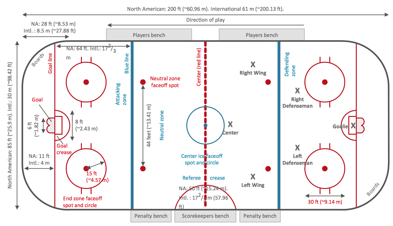
Ice Hockey Rink Dimensions

Meeting ice hockey rules one should learn ice hockey rink terms, lines, zones etc. ConceptDraw DIAGRAM is an advanced drawing software that allows you produce ice hockey rink depiction of any complexity, from simple sketch drawing to detailed one as on example below.

continent map, maps of continents,map of continents, continents map, 7 continents map, continents and oceans map, world continents map Continent Maps

continent map, maps of continents,map of continents, continents map, 7 continents map, continents and oceans map, world continents map
Continent Maps solution extends ConceptDraw DIAGRAM software with templates, samples and libraries of vector stencils for drawing the thematic maps of continents, state maps of USA and Australia.