This site uses cookies. By continuing to browse the ConceptDraw site you are agreeing to our Use of Site Cookies.

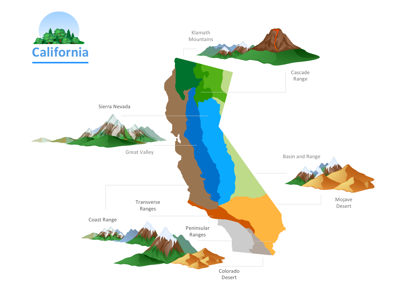
Geo Map - USA - California

California is a state located on the West Coast of the United States.
The vector stencils library California contains contours for ConceptDraw DIAGRAM diagramming and vector drawing software. This library is contained in the Continent Maps solution from Maps area of ConceptDraw Solution Park.

Nature Drawings - How to Draw

Nature solution expands this software possibilities to create beautiful illustrations diagrams with the new library which contains 17 vector objects.

Geo Map — United States of America Map

United States is a federal republic consisting of 50 states and a federal district.
ConceptDraw is idea to draw the geological map of the United States of America from the pre-designed vector geo map shapes.
Each map is scaled, with the option to add further levels of detail - county borders, their names, capitals and major cities can be shown or hidden using the action menu for each state map. ConceptDraw DIAGRAM gives you full control over map size, shading, color fills and alignment.
Use the Continent Maps solution for easy drawing professional looking geological maps, thematic maps, geospatial infographics and vector illustrations for your business documents, presentations and websites.

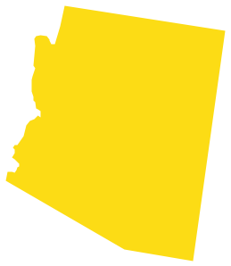
Geo Map - USA - Arizona

Arizona is a state in the southwestern region of the United States.
The vector stencils library Arizona contains contours for ConceptDraw DIAGRAM diagramming and vector drawing software. This library is contained in the Continent Maps solution from Maps area of ConceptDraw Solution Park.

Geo Map - USA - Oregon

Oregon is a state in the Pacific Northwest of the United States.
The vector stencils library Oregon contains contours for ConceptDraw DIAGRAM diagramming and vector drawing software. This library is contained in the Continent Maps solution from Maps area of ConceptDraw Solution Park.

Geo Map - USA - New York

New York is a state in the Northeastern and Mid-Atlantic regions of the United States.
The vector stencils library New York contains contours for ConceptDraw DIAGRAM diagramming and vector drawing software. This library is contained in the Continent Maps solution from Maps area of ConceptDraw Solution Park.

usa map, map of usa, map of usa states, usa map states, usa maps, us map with cities, usa states map, us interstate map, usa map with capitals, printable us map USA Maps

usa map, map of usa, map of usa states, usa map states, usa maps, us map with cities, usa states map, us interstate map, usa map with capitals, printable us map
Use the USA Maps solution to create a map of USA, a US interstate map, printable US maps, US maps with cities and US maps with capitals. Create a complete USA states map.

Geo Map — USA — Montana

Montana is a state in the Western United States.
The vector stencils library Montana contains contours for ConceptDraw DIAGRAM diagramming and vector drawing software. This library is contained in the Continent Maps solution from Maps area of ConceptDraw Solution Park.

Geo Map - USA - Maryland

Maryland is a U.S. state located in the Mid-Atlantic region of the United States, bordering Virginia, West Virginia, and Washington, D.C. to its south and west; Pennsylvania to its north; and Delaware to its east.
The vector stencils library Maryland contains contours for ConceptDraw DIAGRAM diagramming and vector drawing software. This library is contained in the Continent Maps solution from Maps area of ConceptDraw Solution Park.

Geo Map — USA — Michigan

Michigan is a state in the Great Lakes region of the Midwestern United States.
The vector stencils library Michigan contains contours for ConceptDraw DIAGRAM diagramming and vector drawing software. This library is contained in the Continent Maps solution from Maps area of ConceptDraw Solution Park.

Geo Map - USA - Utah

Utah is a state in the United States.
The vector stencils library Utah contains contours for ConceptDraw DIAGRAM diagramming and vector drawing software. This library is contained in the Continent Maps solution from Maps area of ConceptDraw Solution Park.

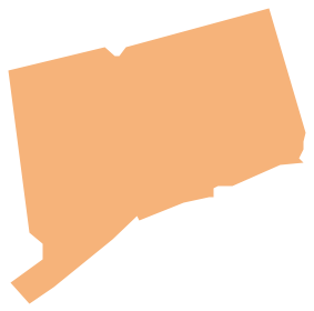
Geo Map - USA - Connecticut

Connecticut is the southernmost state in the northeastern region of the United States known as New England.
The vector stencils library Connecticut contains contours for ConceptDraw DIAGRAM diagramming and vector drawing software. This library is contained in the Continent Maps solution from Maps area of ConceptDraw Solution Park.

Geo Map - USA - West Virginia

West Virginia is a U.S. state located in the Appalachian region of the Southern United States.
The vector stencils library West Virginia contains contours for ConceptDraw DIAGRAM diagramming and vector drawing software. This library is contained in the Continent Maps solution from Maps area of ConceptDraw Solution Park.

Geo Map — USA — Mississippi

Mississippi is a U.S. state located in the Southern United States.
The vector stencils library Mississippi contains contours for ConceptDraw DIAGRAM diagramming and vector drawing software. This library is contained in the Continent Maps solution from Maps area of ConceptDraw Solution Park.

Geo Map - USA - New Hampshire

New Hampshire is a state in the New England region of the northeastern United States of America. The state was named after the southern English county of Hampshire.
The vector stencils library New Hampshire contains contours for ConceptDraw DIAGRAM diagramming and vector drawing software. This library is contained in the Continent Maps solution from Maps area of ConceptDraw Solution Park.