This site uses cookies. By continuing to browse the ConceptDraw site you are agreeing to our Use of Site Cookies.
Use this Africa map template to design your political or thematic map.
This Africa map template for the ConceptDraw PRO diagramming and vector drawing software is included in the Continent Maps solution from the Maps area of ConceptDraw Solution Park.
Africa map
Africa map, North, Equatorial Guinea, Africa,
Used Solutions

Geo Map - Africa

Africa has 54 fully recognized sovereign states, 9 territories and two de facto independent states with limited or no recognition.
Vector design elements library Africa contains country map contours, geographical maps, cartograms and thematic maps for ConceptDraw DIAGRAM diagramming and vector drawing software. To help visualize the business and thematic information connected with geographic areas, locations or customs.
All ConceptDraw DIAGRAM documents are vector graphic files and are available for reviewing, modifying, and converting to a variety of formats: image, HTML, PDF file, MS PowerPoint Presentation, Adobe Flash, MS Visio (.VDX,.VSDX).

How to draw Metro Map style infographics? (New York)

How to draw Metro Map style infographics of New York subway.
New York Subway has a long history starting on October 27, 1904. Since the opening many agencies have provided schemes of the subway system. At present time are 34 lines in use. This page present New York City subway map construct with Metro Map Solution in Conceptdraw DIAGRAM software. This is a one-click tool to add stations to the map. It lets you control the direction in which you create new stations, change lengths, and add text labels and icons. It contains Lines, Stations, and Landmarks objects

Geo Map - Africa - Cameroon

Cameroon, officially the Republic of Cameroon, is a country in the west Central Africa region.
The vector stencils library Cameroon contains contours for ConceptDraw DIAGRAM diagramming and vector drawing software. This library is contained in the Continent Maps solution from Maps area of ConceptDraw Solution Park.

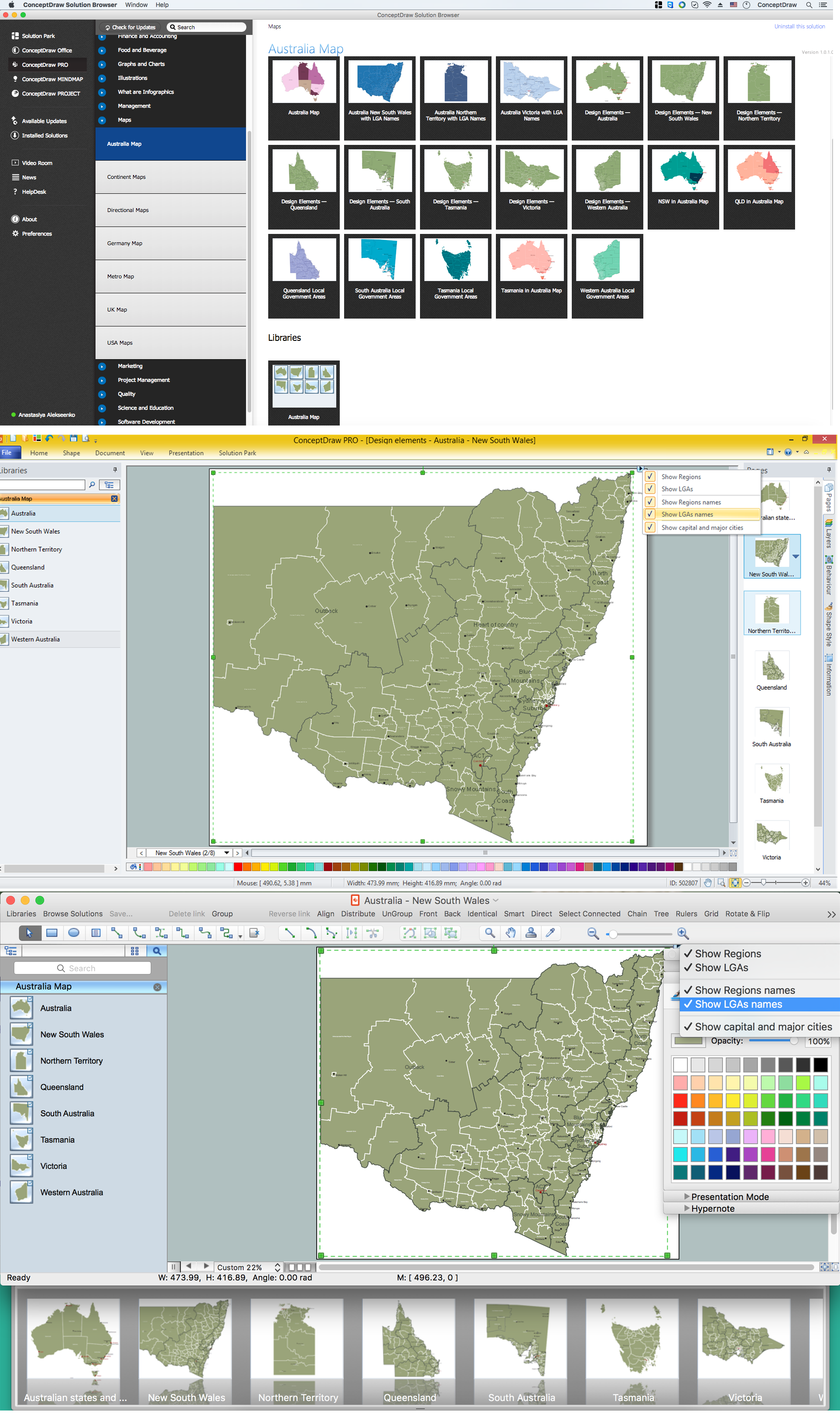
Australia Map — New South Wales

New South Wales (abbreviated as NSW) is a state on the east coast of Australia.
Maps surround us everywhere in our life, study, work, traveling, they are widely used in geography, history, politics, economics, and many other fields of science and life activity. But designing of maps is usually complex and labor-intensive process. Now we have the possibility to make easier this process - ConceptDraw DIAGRAM diagramming and vector drawing software extended with Australia Map Solution from the Maps Area of ConceptDraw Solution Park will help us in easy drawing detailed Australia map.

Geo Map - Europe - Switzerland
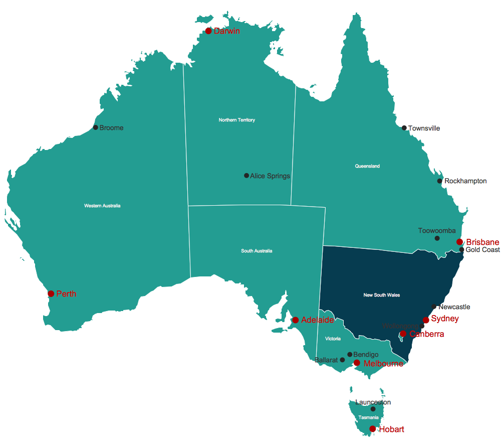
The vector stencils library Switzerland contains contours for ConceptDraw DIAGRAM diagramming and vector drawing software. This library is contained in the Continent Maps solution from Maps area of ConceptDraw Solution Park.

Map Australia

ConceptDraw DIAGRAM diagramming and vector drawing software offers the Australia Map Solution from the Maps Area of ConceptDraw Solution Park - the best tool for fast and easy drawing various types of Australia maps, maps of Australia states and islands, Map Australia with cities, thematic Australia maps and cartograms of any degree of detailing.

Geo Map - Canada - Saskatchewan

Saskatchewan is a prairie province in Canada, which has a total area of 651,900 square kilometres (251,700 sq mi) and a land area of 592,534 square kilometres (228,800 sq mi), the remainder being water area (covered by lakes/ponds, reservoirs and rivers).
The vector stencils library Saskatchewan contains contours for ConceptDraw DIAGRAM diagramming and vector drawing software. This library is contained in the Continent Maps solution from Maps area of ConceptDraw Solution Park.

Geo Map — USA — Oklahoma

Oklahom is a state located in the South Central United States.
The vector stencils library Oklahoma contains contours for ConceptDraw DIAGRAM diagramming and vector drawing software. This library is contained in the Continent Maps solution from Maps area of ConceptDraw Solution Park.

continent map, maps of continents,map of continents, continents map, 7 continents map, continents and oceans map, world continents map Continent Maps

continent map, maps of continents,map of continents, continents map, 7 continents map, continents and oceans map, world continents map
Continent Maps solution extends ConceptDraw DIAGRAM software with templates, samples and libraries of vector stencils for drawing the thematic maps of continents, state maps of USA and Australia.