Made with
ConceptDraw
DIAGRAM 17

Maps of Germany

Germany is a federal parliamentary republic in West-Central Europe which consists of 16 constituent states. It is a part of Schengen area and the most populous member state in the European Union. Germany's territory covers 357,021 km2, it borders with Denmark to the north, Poland and Czech Republic to the east, Austria and Switzerland to the south, France, Luxembourg, Belgium and Netherlands to the west, and is washed by the North Sea and the Baltic Sea. The capital of Germany and largest city is Berlin.

ConceptDraw DIAGRAM diagramming and vector drawing software offers the unique Germany Map Solution from the Maps Area of ConceptDraw Solution Park, developed specially for easy drawing the maps of Germany of different levels of complexity and detailing.

Maps of Germany *

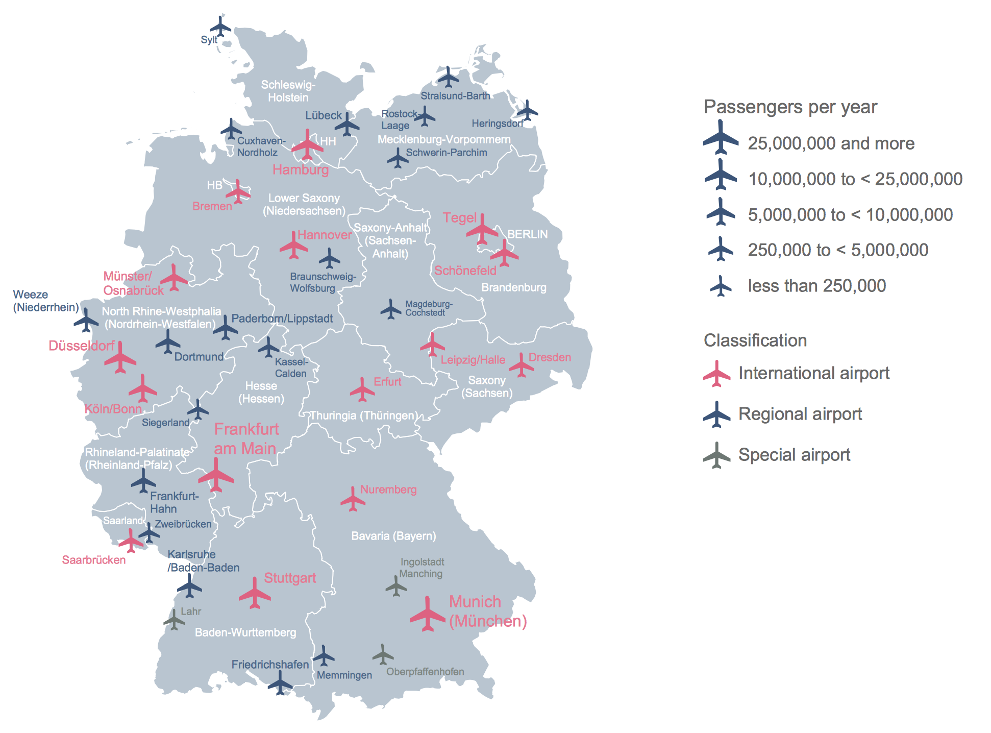
Example 1. Maps of Germany - Airports in Germany

Germany Map Solution for ConcepDraw PRO offers great number of predesigned examples and samples which give you the excellent start for designing your own professional looking maps of Germany and maps of Europe representing Germany as a part of EU.

Germany Map Solution in ConceptDraw STORE

Example 2. Germany Map Solution in ConceptDraw STORE

Turn also your attention for the Germany library included in Germany Map solution. It was developed as an aid for ConceptDraw users, contains 19 vector map objects and occupies a separate place in the list of useful tools for drawing maps.

Map of Germany States

Example 3. Map of Germany States

The maps of Germany you see on this page were created in ConceptDraw DIAGRAM software using objects from the Germany library for Germany Map solution. An experienced user spent 5 minutes creating each of these maps, all they are available from ConceptDraw STORE.

Use the Germany Map solution for ConceptDraw DIAGRAM software to design your own maps of Germany fast, easy and effective.

All source documents are vector graphic documents. They are available for reviewing, modifying, or converting to a variety of formats (PDF file, MS PowerPoint, MS Visio, and many other graphic formats) from the ConceptDraw STORE. The Germany Map Solution is available for all ConceptDraw DIAGRAM users.


FOUR RELATED HOW TO's:
Quebec is a province in east-central Canada. The vector stencils library Quebec contains contours for ConceptDraw DIAGRAM diagramming and vector drawing software. This library is contained in the Continent Maps solution from Maps area of ConceptDraw Solution Park.Geo Map - Canada - Quebec *
Picture: Geo Map - Canada - Quebec
Related Solution:
Bubble diagrams solution extends ConceptDraw DIAGRAM software with templates, Using ConceptDraw Connectors, you can create a bubble chart in moments. Using ConceptDraw you will be able to create a bubble chart from the ready ConceptDraw library objects or make your own objects. The created diagram can represent ideas organization, in brainstorming processes, by teachers for explaining difficult ideas or for presentations.How To Create a Bubble Chart *
Picture: How To Create a Bubble Chart
Related Solution:
Planning a computer network can be a challenge for a junior specialist. However, knowing how to draw a computer network diagrams isn’t a rocket science anymore. There are a lot of special software for creating such diagrams with predesigned templates and examples. The core for Network Fault Tolerance System presented here, is the equipment of Cisco. You can see here the certified Cisco equipment icons. Generally, ConceptDraw DIAGRAM libraries contain more than half of a thousand objects representing the standardized images of Cisco equipment. ConceptDraw solution for network diagramming is a great network diagramming tool for any level skills - from students to network guru.How to Draw a Computer Network Diagrams
Picture: How to Draw a Computer Network Diagrams
Related Solution:
Peru, officially the Republic of Peru, is a country in western South America. The history of Peru goes back to the distant past and its divided into several main stages. Geography of Peru is also diverse - there is a desert, as well as the ocean coast, and of course the mountain ranges. The Continent Maps solution from Maps area of ConceptDraw Solution Park provides stencil library Peru, which is made up of well-designed vector shapes delivering easy experience in creating diagrams with ConceptDraw DIAGRAM software. All ConceptDraw DIAGRAM documents are vector graphic files and are available for reviewing, modifying, and converting to a variety of formats: image, HTML, PDF file, MS PowerPoint Presentation, Adobe Flash, MS Visio (.VDX,.VSDX).Geo Map — South America — Peru *
Picture: Geo Map — South America — Peru
Related Solution:
ConceptDraw
DIAGRAM 17