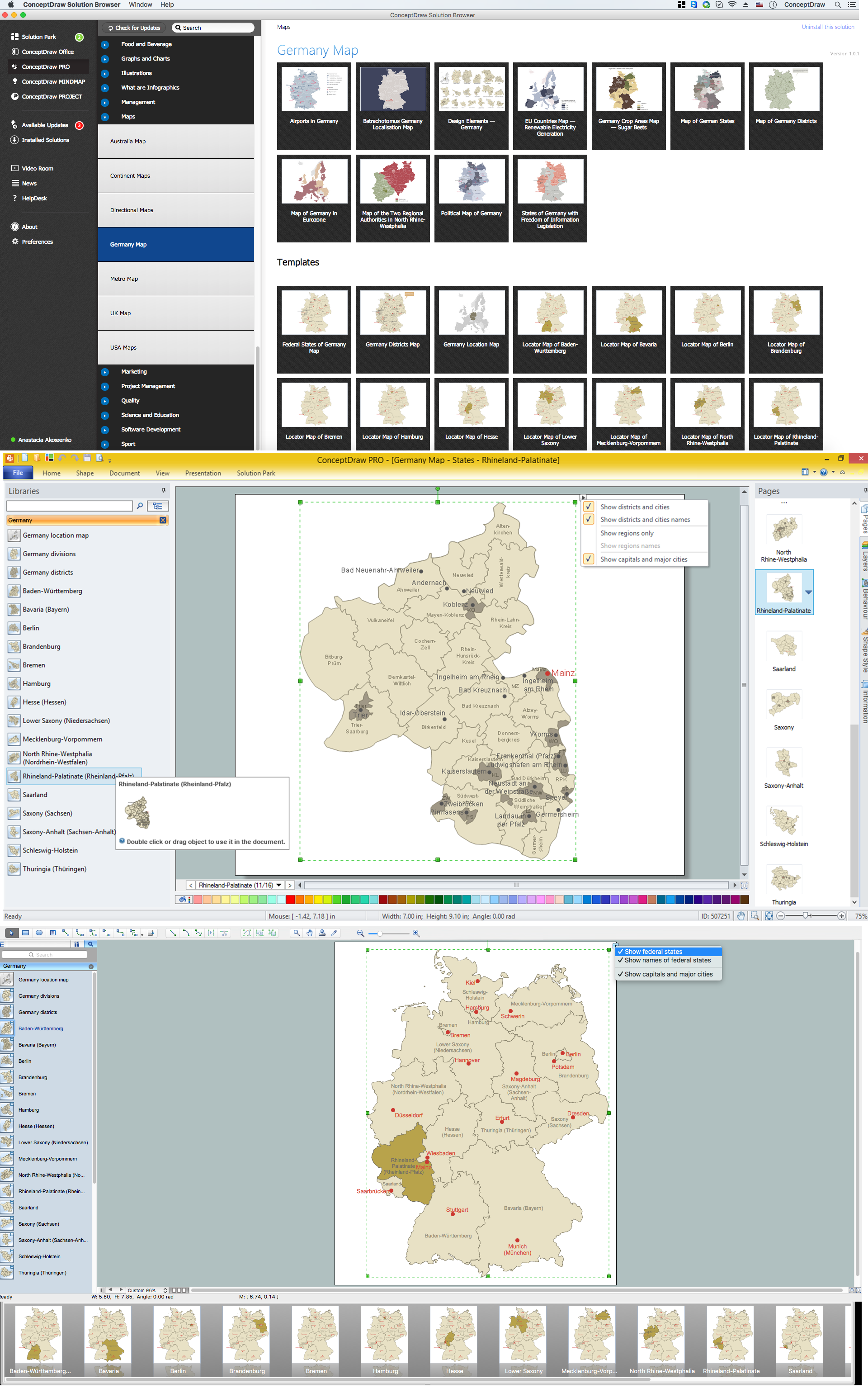
Map of Germany — Rhineland-Palatinate State
“Rhineland-Palatinate is a southwest German state bordered by France, Belgium and Luxembourg. The state capital, Mainz, features Jewish synagogues and cemeteries, the Romanesque Mainz Cathedral with ornate tombstones, and the Gutenberg Museum devoted to the inventor of the printing press. The lush Moselle Valley, with its riverside towns of Piesport and Bernkastel-Kues, is one of Germany's largest wine regions.“
[from Wikipedia]
Landkreise
- Ahrweiler
- Altenkirchen
- Alzey-Worms
- Bad Dürkheim
- Bad Kreuznach
- Bernkastel-Wittlich
- Birkenfeld
- Bitburg-Prüm
- Cochem-Zell
- Vulkaneifel
- Donnersbergkreis
- Germersheim
- Kaiserslautern
- Kusel
- Rhein-Pfalz-Kreis
- Mainz-Bingen
- Mayen-Koblenz
- Neuwied
- Rhein-Hunsrück
- Rhein-Lahn
- Südliche Weinstraße
- Südwestpfalz
- Trier-Saarburg
- Westerwaldkreis
Cities
- Mainz
- Ludwigshafen am Rhein
- Koblenz
- Trier
- Kaiserslautern
- Worms
- Neuwied
- Neustadt an der Weinstraße
- Speyer
- Bad Kreuznach
- Frankenthal (Pfalz)
- Landau in der Pfalz
- Pirmasens
- Zweibrücken
- Andernach
- Idar-Oberstein
- Bad Neuenahr-Ahrweiler
- Ingelheim am Rhein
- Germersheim
Despite the fact that the maps surround us everywhere in our life, usually the process of their drawing is sufficienly complex and labor-intensive. But now, thanks to the ConceptDraw DIAGRAM diagramming and vector drawing software extended with Germany Map Solution from the Maps Area of ConceptDraw Solution Park, we have the possibility to make easier this process. Design fast and easy your own pictorial maps of Germany, map of Germany with cities, and thematic Germany maps in ConceptDraw DIAGRAM
Example 1. Germany Map Solution — Rhineland-Palatinate State (Mac OS X, Windows)
Use of ready objects is a fastest way of drawing vivid and attractive maps and cartograms, and Germany maps are not exception. The Germany Map Solution offers for ConceptDraw DIAGRAM users wide variety of ready-to-use vector map objects, which compose the Germany library.

Example 2. Germany Library Design Elements
These objects allow easy design many kinds of Germany maps, among them geographic, topography, political map of Germany, detailed map of Germany with cities, various thematic Germany maps that are used for visually illustration important information and statistical data, and many other useful maps.
All source documents are vector graphic documents. They are available for reviewing, modifying, or converting to a variety of formats (PDF file, MS PowerPoint, MS Visio, and many other graphic formats) from the ConceptDraw STORE. The Germany Map Solution is available for all ConceptDraw DIAGRAM users.
THREE RELATED HOW TO's:
Lower Saxony is a German state (Bundesland) situated in northwestern Germany and is second in area, with 47,624 square kilometres (18,388 sq mi), and fourth in population (8 million) among the sixteen Länder of Germany.
Despite the fact that the maps surround us everywhere in our life, usually the process of their drawing is sufficienly complex and labor-intensive. But now, thanks to the ConceptDraw DIAGRAM diagramming and vector drawing software extended with Germany Map Solution from the Maps Area of ConceptDraw Solution Park, we have the possibility to make easier this process. Design fast and easy your own pictorial maps of Germany, map of Germany with cities, and thematic Germany maps in ConceptDraw DIAGRAM!
Picture: Map of Germany — Lower Saxony State
Related Solution:
Computer networks nowadays are spread all across the world. The large number of parameters, such as geographic scale or communication protocols, can divide networks. One of the most common types of networks is called local area network (LAN). It convenient to represent network examples by means of diagrams.
This local area network (LAN) diagram provides an easy way to see the way the devices in a local network are interacted. The diagram uses a library containing specific symbols to represent network equipment , media and the end-user devices such as computers (PC, mac, laptop) , network printer, hubs, server and finally a modem. There are two types of network topologies: physical and logical. The current diagram represents precisely a physical type of LAN topology because it refers to the physical layout of a local network equipment.
Picture:
What is a Local Area Network?
Examples of LAN Diagrams
Related Solution:
An integrated circuit (IC) is a chip or microchip that consists of a substrate created from semiconductor material and thousands or millions of tiny electronic components installed on it. ConceptDraw DIAGRAM software with included Digital Electronics solution allows you to choose from an enormous number of vector electrical symbols, integrated circuits, logic gates, connections, flip flop symbols. Collection of the pre-made symbols and also an included set of professionally designed samples are useful to create Integrated circuit schematics of various kinds in minutes.
Picture: Integrated Circuit