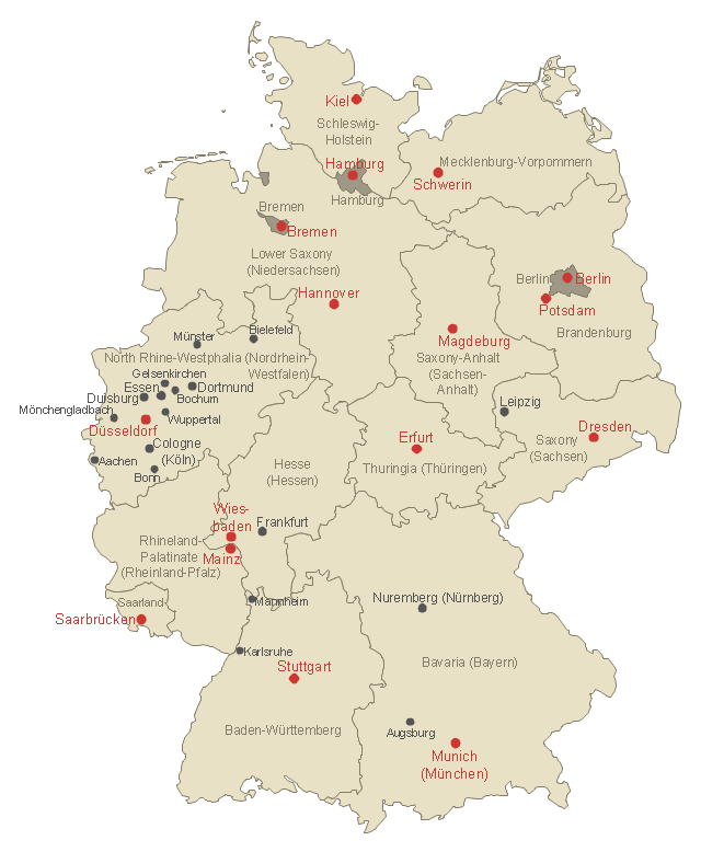
Use this German states map template to design Germany political or thematic maps with ConceptDraw PRO software.
You can show or hide federal state borders or names, or main cities by the map selecting and Action menu commands.
The template "Federal States of Germany map" is included in the Map of Germany solution from the Maps area of ConceptDraw Solution Park.
You can show or hide federal state borders or names, or main cities by the map selecting and Action menu commands.
The template "Federal States of Germany map" is included in the Map of Germany solution from the Maps area of ConceptDraw Solution Park.
German states map template
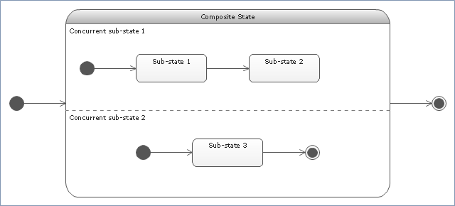
"State machine diagram is a behavior diagram which shows discrete behavior of a part of designed system through finite state transitions. State machine diagrams can also be used to express the usage protocol of part of a system. Two kinds of state machines defined in UML 2.4 are:
(1) behavioral state machine, and
(2) protocol state machine.
The following nodes and edges are typically drawn in state machine diagram: behavioral state, behavioral transition, protocol state, protocol transition, different pseudostates. ...
Behavioral state machine is specialization of behavior and is used to specify discrete behavior of a part of designed system through finite state transitions. The state machine formalism used in this case is an object-based variant of Harel statecharts.
Behavior is modeled as a traversal of a graph of state nodes connected with transitions. Transitions are triggered by the dispatching of series of events. During the traversal, the state machine could also execute some activities. ...
Protocol state machine is a specialization of behavioral state machine and is used to express usage protocol or lifecycle of a classifier. It specifies which operations of the classifier can be called in which state and under which condition, thus specifying the allowed call sequences on the classifier’s operations. Protocol state machines express the legal transitions that a classifier can trigger." [uml-diagrams.org/ state-machine-diagrams.html]
The template "UML state machine diagram" for the ConceptDraw PRO diagramming and vector drawing software is included in the Rapid UML solution from the Software Development area of ConceptDraw Solution Park.
www.conceptdraw.com/ solution-park/ software-uml
UML state machine diagram
 USA Maps
Use the USA Maps solution to create a map of USA, a US interstate map, printable US maps, US maps with cities and US maps with capitals. Create a complete USA states map.
Use this template of North America map with contours of North American countries, capitals and main cities to design your political or thematic map. This North America map template for the ConceptDraw PRO diagramming and vector drawing software is included in the Continent Maps solution from the Maps area of ConceptDraw Solution Park.
North America map template

Use this template to design your North America political map, cartogram or thematic map, to visualize your spatial business information connected with geographic areas, locations or ways.
This North America map template for the ConceptDraw PRO diagramming and vector drawing software is included in the Continent Maps solution from the Maps area of ConceptDraw Solution Park.
This North America map template for the ConceptDraw PRO diagramming and vector drawing software is included in the Continent Maps solution from the Maps area of ConceptDraw Solution Park.
North America thematic map template
HelpDesk
How to Draw a Map of USA States Using ConceptDraw PRO

- USA Maps | Map of USA | Map of USA States | Usa Map Template
- UML state machine diagram - Template | Booch OOD Diagram ...
- Geo Map - United States of America Map | North America map with ...
- Map of USA | Map of USA States | USA Maps | Us Map Template
- Federal States of Germany map - Template
- Us Map With States Names Template
- North American States And His Capitals
- North America map with capitals - Template | Geo Map - USA - West ...
- Organizational chart - New York State Education Department ...
- North America map with capitals - Template | Continents Map | Geo ...
- North America map with capitals - Template | Geo Map - USA ...
- Australia map with cities - Template | Australia Map — States and ...
- North America map with capitals - Template | Geo Map - USA ...
- North America map - Template | Geo Map - South America Continent ...
- Geo Map - United States of America Map | North America map with ...
- North America map - Template | North America map - Template ...
- Australia map with cities - Template | Australia map - Template ...
- North America map with capitals - Template
- North America map with capitals - Template | Continents Map ...
- North America map with capitals - Template | South America map ...