This political map of Canada exhibits its ten provinces and three territories, and their capitals.
"Canada is a country in North America consisting of 10 provinces and 3 territories. Located in the northern part of the continent, it extends from the Atlantic to the Pacific and northward into the Arctic Ocean. At 9.98 million square kilometers in total, Canada is the world's second-largest country by total area, and its common border with the United States is the world's longest land border shared by the same two countries." [Canada. Wikipedia]
This Canada political map was redesigned from Wikipedia file Map Canada political 2.png. [commons.wikimedia.org/ wiki/ File:Map_ Canada_ political_ 2.png]
The example "Canada political map" was created using the ConceptDraw PRO diagramming and vector drawing software extended with the Continent Maps solution from the Maps area of ConceptDraw Solution Park.
Political map - Canada

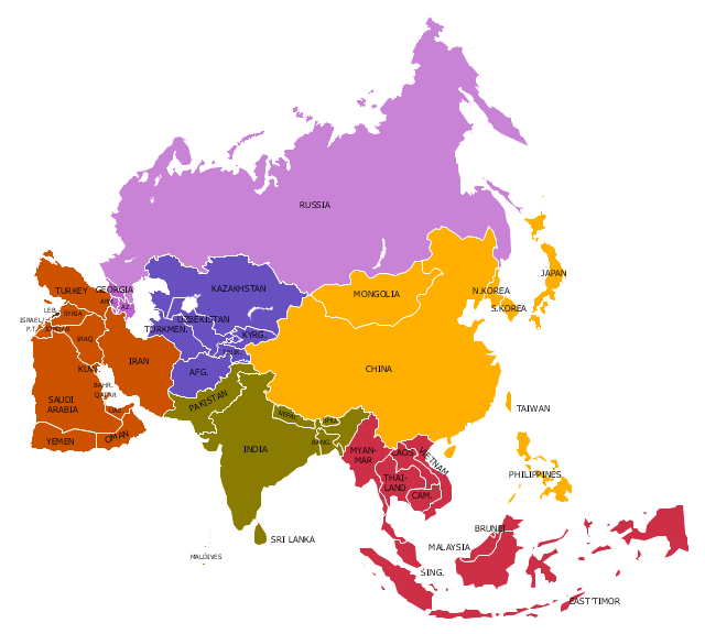
"Asia ... is the world's largest and most populous continent, located primarily in the eastern and northern hemispheres. It covers 8.7% of the Earth's total surface area and comprises 30% of its land area. With approximately 4.3 billion people, it hosts 60% of the world's current human population. Asia has a high growth rate in the modern era. For instance, during the 20th century, Asia's population nearly quadrupled." [Asia. Wikipedia]
This Asia political map was redesigned from Wikimedia Commons file: Map of Asia.svg.
[commons.wikimedia.org/ wiki/ File:Map_ of_ Asia.svg]
This file is licensed under the Creative Commons Attribution-Share Alike 3.0 Unported license. [creativecommons.org/ licenses/ by-sa/ 3.0/ deed.en]
Legend:
Purple = North Asia/ Eurasia (Russia, Georgia, Armenia, Azerbaijan),
Yellow = East Asia (China, Mongolia, Korea, Japan),
Red = South East Asia (10 ASEAN countries + East Timor),
Green = South Asia (India, Pakistan, Bangladesh, Nepal, Bhutan),
Brown = West Asia/ Middle East,
Blue = Central Asia.
The example "Political map of Asia" was created using the ConceptDraw PRO diagramming and vector drawing software extended with the Continent Maps solution from the Maps area of ConceptDraw Solution Park.
Political map - Asia
"Alphabetical list of subregions in the United Nations geoscheme for Europe.
Eastern Europe: Belarus, Bulgaria, Czech Republic, Hungary, Moldova, Poland, Romania, Russia, Slovakia, Ukraine.
Northern Europe: Åland Islands, Denmark, Estonia, Faroe Islands, Finland, Guernsey, Iceland, Ireland, Isle of Man, Jersey, Latvia, Lithuania, Norway, Svalbard and Jan Mayen, Sweden, United Kingdom.
Southern Europe: Albania, Andorra, Bosnia and Herzegovina, Croatia, Gibraltar, Greece, Italy, Malta, Montenegro, Portugal, Macedonia, San Marino, Serbia, Slovenia, Spain, Vatican City.
Western Europe: Austria, Belgium, France, Germany, Liechtenstein, Luxembourg, Monaco, Netherlands, Switzerland." [United Nations geoscheme for Europe. Wikipedia]
The example "Political map of Europe" illustrated with European state flags was created using the ConceptDraw PRO diagramming and vector drawing software extended with the Continent Maps solution from the Maps area of ConceptDraw Solution Park.
Political map - Europe

"Central Asia is the core region of the Asian continent and stretches from the Caspian Sea in the west to China in the east and from Afghanistan in the south to Russia in the north. It is also sometimes referred to as Middle Asia, and, colloquially, "the 'stans" (as the five countries generally considered to be within the region all have names ending with the Persian suffix "-stan", meaning "land of") and is within the scope of the wider Eurasian continent.
In modern contexts, all definitions of Central Asia include these five republics of the former Soviet Union: Kazakhstan ..., Kyrgyzstan ..., Tajikistan ..., Turkmenistan ..., and Uzbekistan ... Other areas sometimes included are Afghanistan, Mongolia, eastern Iran, and northwestern Pakistan, and sometimes Xinjiang and Tibet in western China, the Kashmir region of northern India and northern Pakistan, and southern Siberia in southern Russia." [Central Asia. Wikipedia]
This Central Asia political map was redesigned from Wikimedia Commons file: Central Asia - political map - 2000.svg.
[commons.wikimedia.org/ wiki/ File:Central_ Asia_ -_ political_ map_ -_ 2000.svg]
This file is licensed under the Creative Commons Attribution-Share Alike 3.0 Unported license. [creativecommons.org/ licenses/ by-sa/ 3.0/ deed.en]
The political map example "Central Asia" was drawn using the ConceptDraw PRO diagramming and vector drawing software extended with the design elements library Asia.
The political map example "Central Asia" is included in the Continent Maps solution from the Maps area of ConceptDraw Solution Park.
Political map - Central Asia

"Central America ... is the central geographic region of the Americas. It is the southernmost, isthmian portion of the North American continent, which connects with South America on the southeast. When considered part of the unified continental model, it is considered a subcontinent. Central America consists of seven countries: Belize, Costa Rica, El Salvador, Guatemala, Honduras, Nicaragua, and Panama. Central America is part of the Mesoamerican biodiversity hotspot, which extends from northern Guatemala through central Panama. It is bordered by Mexico to the north, the Caribbean Sea to the east, the North Pacific Ocean to the west, and Colombia to the south-east, which is also the most southern point of North America." [Central America. Wikipedia]
This example Political map of Central America was redesigned from Wikimedia Commons file: Map of Central America.png. [commons.wikimedia.org/ wiki/ File:Map_ of_ Central_ America.png]
This file is licensed under the Creative Commons Attribution-Share Alike 3.0 Unported license. [creativecommons.org/ licenses/ by-sa/ 3.0/ deed.en]
The example "Political map of Central America" was created using the ConceptDraw PRO diagramming and vector drawing software extended with the Continent Maps solution from the Maps area of ConceptDraw Solution Park.
Political map - Central America

This political map of Canada exhibits its ten provinces and three territories, and their capitals.
"Canada is a country in North America consisting of 10 provinces and 3 territories. Located in the northern part of the continent, it extends from the Atlantic to the Pacific and northward into the Arctic Ocean. At 9.98 million square kilometers in total, Canada is the world's second-largest country by total area, and its common border with the United States is the world's longest land border shared by the same two countries." [Canada. Wikipedia]
This Canada political map was redesigned from Wikipedia file Map Canada political 2.png. [commons.wikimedia.org/ wiki/ File:Map_ Canada_ political_ 2.png]
The example "Canada political map" was created using the ConceptDraw PRO diagramming and vector drawing software extended with the Continent Maps solution from the Maps area of ConceptDraw Solution Park.
"Canada is a country in North America consisting of 10 provinces and 3 territories. Located in the northern part of the continent, it extends from the Atlantic to the Pacific and northward into the Arctic Ocean. At 9.98 million square kilometers in total, Canada is the world's second-largest country by total area, and its common border with the United States is the world's longest land border shared by the same two countries." [Canada. Wikipedia]
This Canada political map was redesigned from Wikipedia file Map Canada political 2.png. [commons.wikimedia.org/ wiki/ File:Map_ Canada_ political_ 2.png]
The example "Canada political map" was created using the ConceptDraw PRO diagramming and vector drawing software extended with the Continent Maps solution from the Maps area of ConceptDraw Solution Park.
Political map - Canada
"Central Asia is the core region of the Asian continent and stretches from the Caspian Sea in the west to China in the east and from Afghanistan in the south to Russia in the north. It is also sometimes referred to as Middle Asia, and, colloquially, "the 'stans" (as the five countries generally considered to be within the region all have names ending with the Persian suffix "-stan", meaning "land of") and is within the scope of the wider Eurasian continent.
In modern contexts, all definitions of Central Asia include these five republics of the former Soviet Union: Kazakhstan ..., Kyrgyzstan ..., Tajikistan ..., Turkmenistan ..., and Uzbekistan ... Other areas sometimes included are Afghanistan, Mongolia, eastern Iran, and northwestern Pakistan, and sometimes Xinjiang and Tibet in western China, the Kashmir region of northern India and northern Pakistan, and southern Siberia in southern Russia." [Central Asia. Wikipedia]
This Central Asia political map was redesigned from Wikimedia Commons file: Central Asia - political map - 2000.svg.
[commons.wikimedia.org/ wiki/ File:Central_ Asia_ -_ political_ map_ -_ 2000.svg]
This file is licensed under the Creative Commons Attribution-Share Alike 3.0 Unported license. [creativecommons.org/ licenses/ by-sa/ 3.0/ deed.en]
The political map example "Central Asia" was drawn using the ConceptDraw PRO diagramming and vector drawing software extended with the design elements library Asia.
The political map example "Central Asia" is included in the Continent Maps solution from the Maps area of ConceptDraw Solution Park.
In modern contexts, all definitions of Central Asia include these five republics of the former Soviet Union: Kazakhstan ..., Kyrgyzstan ..., Tajikistan ..., Turkmenistan ..., and Uzbekistan ... Other areas sometimes included are Afghanistan, Mongolia, eastern Iran, and northwestern Pakistan, and sometimes Xinjiang and Tibet in western China, the Kashmir region of northern India and northern Pakistan, and southern Siberia in southern Russia." [Central Asia. Wikipedia]
This Central Asia political map was redesigned from Wikimedia Commons file: Central Asia - political map - 2000.svg.
[commons.wikimedia.org/ wiki/ File:Central_ Asia_ -_ political_ map_ -_ 2000.svg]
This file is licensed under the Creative Commons Attribution-Share Alike 3.0 Unported license. [creativecommons.org/ licenses/ by-sa/ 3.0/ deed.en]
The political map example "Central Asia" was drawn using the ConceptDraw PRO diagramming and vector drawing software extended with the design elements library Asia.
The political map example "Central Asia" is included in the Continent Maps solution from the Maps area of ConceptDraw Solution Park.
Political map - Central Asia
"Alphabetical list of subregions in the United Nations geoscheme for Europe.
Eastern Europe: Belarus, Bulgaria, Czech Republic, Hungary, Moldova, Poland, Romania, Russia, Slovakia, Ukraine.
Northern Europe: Åland Islands, Denmark, Estonia, Faroe Islands, Finland, Guernsey, Iceland, Ireland, Isle of Man, Jersey, Latvia, Lithuania, Norway, Svalbard and Jan Mayen, Sweden, United Kingdom.
Southern Europe: Albania, Andorra, Bosnia and Herzegovina, Croatia, Gibraltar, Greece, Italy, Malta, Montenegro, Portugal, Macedonia, San Marino, Serbia, Slovenia, Spain, Vatican City.
Western Europe: Austria, Belgium, France, Germany, Liechtenstein, Luxembourg, Monaco, Netherlands, Switzerland." [United Nations geoscheme for Europe. Wikipedia]
The example "Political map of Europe" illustrated with European state flags was created using the ConceptDraw PRO diagramming and vector drawing software extended with the Continent Maps solution from the Maps area of ConceptDraw Solution Park.
Eastern Europe: Belarus, Bulgaria, Czech Republic, Hungary, Moldova, Poland, Romania, Russia, Slovakia, Ukraine.
Northern Europe: Åland Islands, Denmark, Estonia, Faroe Islands, Finland, Guernsey, Iceland, Ireland, Isle of Man, Jersey, Latvia, Lithuania, Norway, Svalbard and Jan Mayen, Sweden, United Kingdom.
Southern Europe: Albania, Andorra, Bosnia and Herzegovina, Croatia, Gibraltar, Greece, Italy, Malta, Montenegro, Portugal, Macedonia, San Marino, Serbia, Slovenia, Spain, Vatican City.
Western Europe: Austria, Belgium, France, Germany, Liechtenstein, Luxembourg, Monaco, Netherlands, Switzerland." [United Nations geoscheme for Europe. Wikipedia]
The example "Political map of Europe" illustrated with European state flags was created using the ConceptDraw PRO diagramming and vector drawing software extended with the Continent Maps solution from the Maps area of ConceptDraw Solution Park.
Political map - Europe
Use this template for creating the directional maps, location plans, site schemes, transit schemes, road maps, route maps.
"A road map or route map is a map that primarily displays roads and transport links rather than natural geographical information. It is a type of navigational map that commonly includes political boundaries and labels, making it also a type of political map. In addition to roads and boundaries, road maps often include points of interest, such as prominent businesses or buildings, tourism sites, parks and recreational facilities, hotels and restaurants, as well as airports and train stations. A road map may also document non-automotive transit routes, although often these are found only on transit maps." [Road map. Wikipedia]
This template for the ConceptDraw PRO diagramming and vector drawing software is included in the Directional Maps solution from the Maps area of ConceptDraw Solution Park.
Directional map template

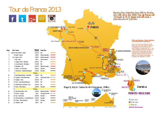
This route map example was redesigned from the Wikipedia file: Route of the 2013 Tour de France.png.
[en.wikipedia.org/ wiki/ File:Route_ of_ the_ 2013_ Tour_ de_ France.png]
This file is licensed under the Creative Commons Attribution-Share Alike 3.0 Unported license. [creativecommons.org/ licenses/ by-sa/ 3.0/ deed.en]
"A road map or route map is a map that primarily displays roads and transport links rather than natural geographical information. It is a type of navigational map that commonly includes political boundaries and labels, making it also a type of political map. In addition to roads and boundaries, road maps often include points of interest, such as prominent businesses or buildings, tourism sites, parks and recreational facilities, hotels and restaurants, as well as airports and train stations. A road map may also document non-automotive transit routes, although often these are found only on transit maps." [Road map. Wikipedia]
The spatial infographics example "The 100th Tour de France - Route map" was created using the ConceptDraw PRO diagramming and vector drawing software extended with the Spatial Infographics solution from the area "What is Infographics" of ConceptDraw Solution Park.
Route map
Geo Map - Canada - Nunavut

The vector stencils library Nunavut contains contours for ConceptDraw PRO diagramming and vector drawing software. This library is contained in the Continent Maps solution from Maps area of ConceptDraw Solution Park.
"A thematic map is a map that focuses on a specific theme or subject area, whereas in a general map the variety of phenomena - geological, geographical, political - regularly appear together. The contrast between them lies in the fact that thematic maps use the base data, such as coastlines, boundaries and places, only as points of reference for the phenomenon being mapped. General maps portray the base data, such as landforms, lines of transportation, settlements, and political boundaries, for their own sake." [Thematic map. Wikipedia]
The template "Europe thematic map" for the ConceptDraw PRO diagramming and vector drawing software is included in the Spatial Infographics solution from the area "What is Infographics" of ConceptDraw Solution Park.
The template "Europe thematic map" for the ConceptDraw PRO diagramming and vector drawing software is included in the Spatial Infographics solution from the area "What is Infographics" of ConceptDraw Solution Park.
Europe contour map
 Continent Maps
Continent Maps solution extends ConceptDraw PRO software with templates, samples and libraries of vector stencils for drawing the thematic maps of continents, state maps of USA and Australia.
Geo Map - USA - Kansas

The vector stencils library Kansas contains contours for ConceptDraw PRO diagramming and vector drawing software. This library is contained in the Continent Maps solution from Maps area of ConceptDraw Solution Park.
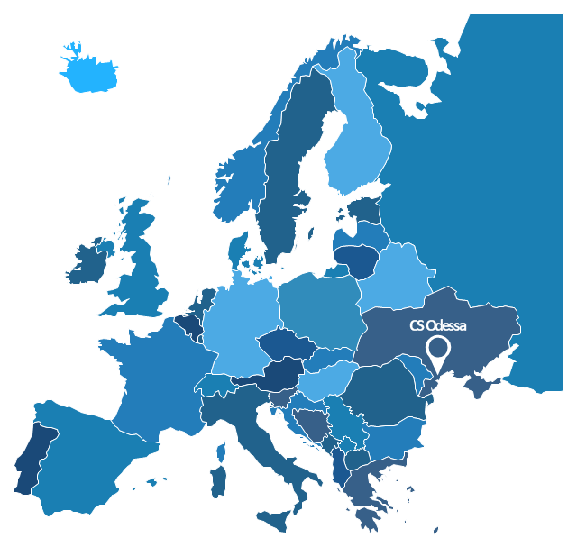
A map showing European membership of the EU and NATO.
"The European Union (EU) is an economic and political union of 28 member states that are located primarily in Europe.
The EU operates through a system of supranational independent institutions and intergovernmental negotiated decisions by the member states. Institutions of the EU include the European Commission, the Council of the European Union, the European Council, the Court of Justice of the European Union, the European Central Bank, the Court of Auditors, and the European Parliament. The European Parliament is elected every five years by EU citizens. The EU's de facto capital is Brussels." [European Union. Wikipedia]
"The principal military alliance in Europe remains NATO, which includes 21 of all EU member states as well as other non-EU European countries, Turkey, the United States and Canada." [Military of the European Union. Wikipedia]
"The North Atlantic Treaty Organization (NATO), also called the (North) Atlantic Alliance, is an intergovernmental military alliance based on the North Atlantic Treaty which was signed on 4 April 1949. The organization constitutes a system of collective defence whereby its member states agree to mutual defense in response to an attack by any external party. NATO's headquarters are in Brussels, Belgium, one of the 28 member states across North America and Europe, the newest of which, Albania and Croatia, joined in April 2009." [NATO. Wikipedia]
This Europe map example was redesigned using the ConceptDraw PRO diagramming and vector drawing software from the Wikimedia Commons file: EU and NATO.svg.
[commons.wikimedia.org/ wiki/ File:EU_ and_ NATO.svg]
The Europe political map example "European membership of the EU and NATO map" is included in the Continent Maps solution from the Maps area of ConceptDraw Solution Park.
Political map - EU and NATO

"A thematic map is a type of map or chart especially designed to show a particular theme connected with a specific geographic area. ...
A thematic map is a map that focuses on a specific theme or subject area, whereas in a general map the variety of phenomena - geological, geographical, political - regularly appear together. ...
Thematic maps emphasize spatial variation of one or a small number of geographic distributions. These distributions may be physical phenomena such as climate or human characteristics such as population density and health issues. ...
Thematic map are sometimes referred to as graphic essays that portray spatial variations and interrelationships of geographical distributions. Location, of course, is important to provide a reference base of where selected phenomena are occurring. ...
Thematic maps serve three primary purposes.
First, they provide specific information about particular locations.
Second, they provide general information about spatial patterns.
Third, they can be used to compare patterns on two or more maps." [Thematic map. Wikipedia]
The vector stencils library "Thematic maps" contains 7 continent map contours for creating the thematic maps of geographic regions displaying the metric values by countries, states and territories marked by different colors.
Use the design elements library "Thematic maps" to create spatial dashboards using the ConceptDraw PRO diagramming and vector drawing software for your Spatial Intelligence and Location Intelligence business practice.
The example "Design elements - Thematic maps" is included in the Spatial Dashboard solution from the area "What is a Dashboard" of ConceptDraw Solution Park.
Thematic map templates

Geo Map - Europe - Germany

Geo Map - USA - Virginia

The vector stencils library Virginia contains contours for ConceptDraw PRO diagramming and vector drawing software. This library is contained in the Continent Maps solution from Maps area of ConceptDraw Solution Park.
"A state of the United States of America is one of the 50 constituent political entities that shares its sovereignty with the United States federal government."
[U.S. state. Wikipedia]
This political map example was redesigned from the Wikimedia Commons file: Map of USA with state names 2.svg.
[commons.wikimedia.org/ wiki/ File:Map_ of_ USA_ with_ state_ names_ 2.svg]
This file is licensed under the Creative Commons Attribution-Share Alike 3.0 Unported license. [creativecommons.org/ licenses/ by-sa/ 3.0/ deed.en]
The example "Map of USA with state names" was created using the ConceptDraw PRO diagramming and vector drawing software extended with the Continent Map solution from the Maps area of ConceptDraw Solution Park.
Political map - USA

A color-coded map showing US state-by-state status of Benefit Corporation legislation.
"A thematic map is a type of map or chart especially designed to show a particular theme connected with a specific geographic area. These maps "can portray physical, social, political, cultural, economic, sociological, agricultural, or any other aspects of a city, state, region, nation, or continent"." [Thematic map. Wikipedia]
This U.S.A. thematic map was redesigned from Wikipedia file: Benefit Corporation Map 2012 05 16.svg. [commons.wikimedia.org/ wiki/ File:Benefit_ Corporation_ Map_ 2012_ 05_ 16.svg]
This file is licensed under the Creative Commons Attribution-Share Alike 3.0 Unported license.
[creativecommons.org/ licenses/ by-sa/ 3.0/ deed.en]
This U.S. thematic map example was created using the ConceptDraw PRO diagramming and vector drawing software extended with the Continent Maps solution from the Maps area of ConceptDraw Solution Park.
Thematic map of U.S.

- Political map of Europe |
- Political map of Central America | Political map of Asia | Central Asia ...
- Political map of Europe | Europe - Thematic map template | Geo Map ...
- Political map of Europe | Tools to Create Your Own Infographics ...
- Political map of Europe | Geo Map - Europe ... - Conceptdraw.com
- Canada political map | Canada regions map | Geo Map - Canada |
- Political map of Europe | Geo Map - Europe - Poland | Geo Map ...
- Continent Maps | Political map of Central America | Political map of ...
- Map of USA with state names | Central Asia political map | Geo Map ...
- Political map of Europe | Map Software | Continent Maps |
- Political map of Europe | Geo Map - Europe - United Kingdom ...
- Geo Map - Europe - Romania | Political map of ... - Conceptdraw.com
- Geo Map - Europe - Poland | Political map of ... - Conceptdraw.com
- Picture graph - Population growth by continent, 2010 - 2013 ...
- Geo Map - Europe - Sweden | Political map of Europe | Geo Map ...
- Geo Map - Asia - Singapore | Political map of Asia | Geo Map - Asia ...
- Geo Map - Europe - Serbia | Political map of Europe | Geo Map ...
- Geo Map - Asia - Pakistan | Central Asia political ... - Conceptdraw.com
- Geo Map - Europe - France | Political map of Europe | Geo Map ...
- Geo Map - Europe - Ukraine | Political map of ... - Conceptdraw.com