Spatial infographics Design Elements: Location Map
Infographic Design Elements for visually present various geographically distributed information.This location map sample was created on the base on the map "Location of the Migration Health Assessment Center (MHAC)" from the website of the U.S. Embassy in Nepal. "Applicants for U.S. immigrant visas and transportation letters are required to have medical examinations performed by IOM (International Organization for Migration) Embassy panel physicians. ... Health assessments for the immigrants to the US are conducted by the International Organization for Migration (IOM) at the Migration Health Assessment Center."
[nepal.usembassy.gov/ visas/ immigrant-visas/ medical-exams.html]
The location map example "Location of the Migration Health Assessment Center (MHAC)" was created using the ConceptDraw PRO diagramming and vector drawing software extended with the Directional Maps solution from the Maps area of ConceptDraw Solution Park.
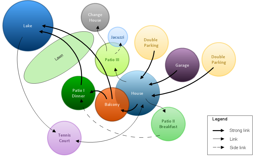
Bubble diagrams in Landscape Design with ConceptDraw DIAGRAM
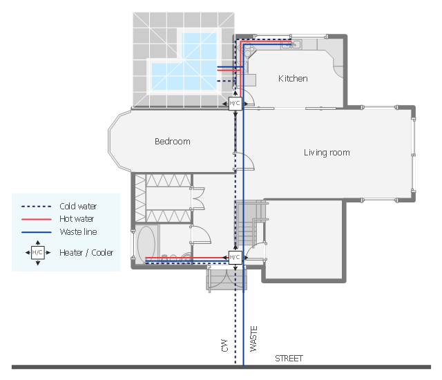
Bubble Diagrams are the charts with a bubble presentation of data with obligatory consideration of bubble's sizes. They are analogs of Mind Maps and find their application at many fields, and even in landscape design. At this case the bubbles are applied to illustrate the arrangement of different areas of future landscape design, such as lawns, flowerbeds, playgrounds, pools, recreation areas, etc. Bubble Diagram helps to see instantly the whole project, it is easy for design and quite informative, in most cases it reflects all needed information. Often Bubble Diagram is used as a draft for the future landscape project, on the first stage of its design, and in case of approval of chosen design concept is created advanced detailed landscape plan with specification of plants and used materials. Creation of Bubble Diagrams for landscape in ConceptDraw DIAGRAM software is an easy task thanks to the Bubble Diagrams solution from "Diagrams" area. You can use the ready scanned location plan as the base or create it easy using the special ConceptDraw libraries and templates.This plumbing and piping plan sample depicts the house hot and cold water supply and sanitation system.
"Within industry, piping is a system of pipes used to convey fluids (liquids and gases) from one location to another. The engineering discipline of piping design studies the efficient transport of fluid. ...
Plumbing is a piping system with which most people are familiar, as it constitutes the form of fluid transportation that is used to provide potable water and fuels to their homes and businesses. Plumbing pipes also remove waste in the form of sewage, and allow venting of sewage gases to the outdoors. Fire sprinkler systems also use piping, and may transport nonpotable or potable water, or other fire-suppression fluids." [Piping. Wikipedia]
The water supply and waste removal system scheme example "House plumbing plan" was created using the ConceptDraw PRO diagramming and vector drawing software extended with the Plumbing and Piping Plans solution from the Building Plans area of ConceptDraw Solution Park.
- Spatial infographics Design Elements: Location Map | How To use ...
- How To use House Electrical Plan Software | Fire Exit Plan. Building ...
- How To use House Electrical Plan Software | Spatial infographics ...
- How To use House Electrical Plan Software | Location Of Motion ...
- Electrical Drawing Software and Electrical Symbols | How To use ...
- Landmarks - Vector stencils library | Design elements - Location ...
- How To use House Electrical Plan Software | Cafe electrical floor ...
- Location of the Migration Health Assessment Center (MHAC) | Mhac ...
- Location Plan
- 2D Directional map - Template | Landmarks - Vector stencils library ...
- How To Create A 2d Location Map
- How To use House Electrical Plan Software | Visual Presentations ...
- How To use House Electrical Plan Software | Cisco Products ...
- How To use House Electrical Plan Software | Process Flowchart ...
- How To use House Electrical Plan Software | How To use Building ...
- How To use House Plan Software | Restaurant Floor Plans | How To ...
- Bubble diagrams in Landscape Design with ConceptDraw PRO ...
- How To use House Electrical Plan Software | How To Create ...
- How To use House Electrical Plan Software | Home Design Software ...
- Building Drawing Design Element: Piping Plan | How To use House ...

.png--diagram-flowchart-example.png)

