How it works : eLearning


This example was designed on the base of infographic "International education" from the Great Britain Government website.
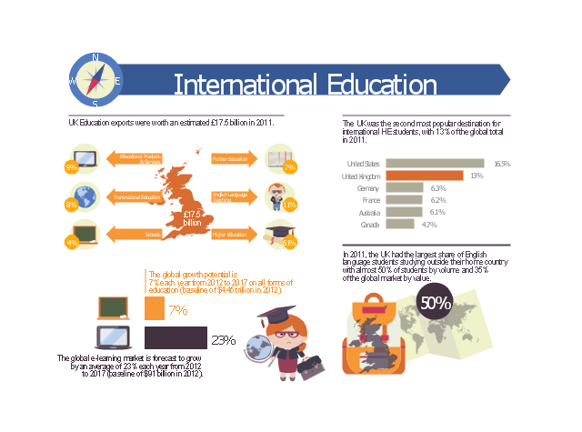
"UK Education exports were worth an estimated £17.5 billion in 2011.
The UK was the second most popular destination for international HE students, with 13% of the global total in 2011.
The global growth potential is 7% each year from 2012 to 2017 on all forms of education (baseline of $4.45 trillion in 2012).
In 2011, the UK had the largest share of English language students studying outside their home country with almost 50% of students by volume and 35% of the global market by value.
The global e-learning market is forecast to grow by an average of 23% each year from 2012 to 2017 (baseline of $91 billion in 2012)." [gov.uk/ government/ uploads/ system/ uploads/ attachment_ data/ file/ 225562/ international-education-industrial-strategy-infographics.pdf]
The educational infogram "International education" was created using the ConceptDraw PRO diagramming and vector drawing software extended with the Education Infographics solition from the area "Business Infographics" in ConceptDraw Solution Park.
Educational infogram
Map of UK

United Kingdom Cities

Map of UK — Channel Islands

Map of UK — Wales Subdivisions and Towns

Map of UK — England Regions and counties

Map of UK — Cornwall

Map of UK — Northern Ireland

Map of UK — England

Contours Map of UK

- Learning Information
- Language Learning | Skype - eLearning Learning | Create Learning ...
- How to Resize Objects Disproportionately in ConceptDraw PRO ...
- How to Draw Biology Diagram in ConceptDraw PRO | How to Draw ...
- Bubble Chart | Software Flow Chart | Market Chart | How To Make ...
- Education charts - Vector stencils library | Education infogram 5 ...
- How to Draw a Сonstellation Сhart | How to Create Education ...
- How to Draw Physics Diagrams in ConceptDraw PRO | How to Draw ...
- Design elements - Education maps (World map) | Education ...
- IDEF9 Standard | Data Flow Diagram Software | Last resort hotel ...
- How to Purchase ConceptDraw Products for Academic/Nonprofit ...
- SSADM Diagram | Network diagrams with ConceptDraw PRO ...
- Example of DFD for Online Store (Data Flow Diagram) DFD ...
- Last resort hotel book room process - DFD | Data Flow Diagrams ...
- Last resort hotel book room process - DFD | Sales Flowcharts ...
- Last resort hotel book room process - DFD | Hotel Service Process ...
- Sales Flowcharts | Sales Process Management | Last resort hotel ...
- Taxi Service Data Flow Diagram DFD Example | Last resort hotel ...
- Last resort hotel book room process - DFD | Data Flow Diagram ...