"The election of the President and the Vice President of the United States is an indirect vote in which citizens cast ballots for a slate of members of the U.S. Electoral College; these electors in turn directly elect the President and Vice President. Presidential elections occur quadrennially (the count beginning with the year 1792) on Election Day, the Tuesday between November 2 and 8, coinciding with the general elections of various other federal, states and local races. The most recent was the 2012 election, held on November 6. The next election will be the 2016 election, which will be held on November 8, 2016." [United States presidential election. Wikipedia]
This U.S.A. thematic map was redesigned from Wikipedia file: 2012 U.S. Presidential Election Results.jpg. [commons.wikimedia.org/ wiki/ File:2012_ U.S._ Presidential_ Election_ Results.jpg]
This file is licensed under the Creative Commons Attribution-Share Alike 3.0 Unported license.
[creativecommons.org/ licenses/ by-sa/ 3.0/ deed.en]
This U.S. thematic map example was created using ConceptDraw PRO diagramming and vector drawing software extended with Continent Maps solution from Maps area of ConceptDraw Solution Park.
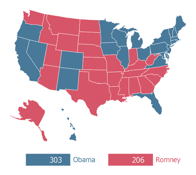
Thematic map - 2012 US presidential election
Geo Map — United States of America Map

Geo Map of Americas

 Continent Maps
Continent Maps solution extends ConceptDraw DIAGRAM software with templates, samples and libraries of vector stencils for drawing the thematic maps of continents, state maps of USA and Australia.
- Election Results 2016 Usa
- Bargraph On 2016 Elections Results
- Example Of Bar Graph 2016 Election Results
- Continent Maps | 2016 Election Results Pie Chart
- Official Us Election Results 2016 Diagram
- 2016 Election Bar Chat Results
- 2012 United States presidential election results | Geo Map - United ...
- Continent Maps | Election 2016 Bar Graph
- London election results | 2012 United States presidential election ...
- Bar Graph 2016 Election
- Prepare Bar Chart And Pie Chart Of Election Result
- Prepare A Bar Chart Of Election Results
- London election results | Bar Diagram Math | Basic Divided Bar ...
- Election 2016 Usa Diagram
- Bar Graph For 2016 Results
- London election results | Bar Diagram Math | Basic Divided Bar ...
- Demonstrating Results | How To Use Skype for Business | Sochi ...
- How To use House Electrical Plan Software | CAD Drawing Software ...
- Election Flowchart Sample
- London election results - Divided bar diagram | Bar Diagram Math ...