Geo Map - Asia - United Arab Emirates

Geo Map - Asia - Philippines

Map of Germany — Saarland State

Electrical Symbols, Electrical Diagram Symbols

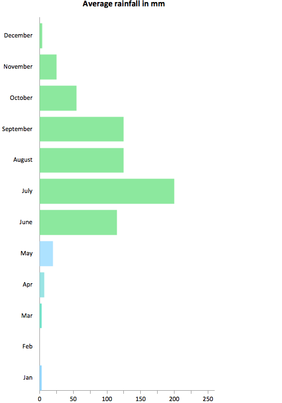
Rainfall Bar Chart
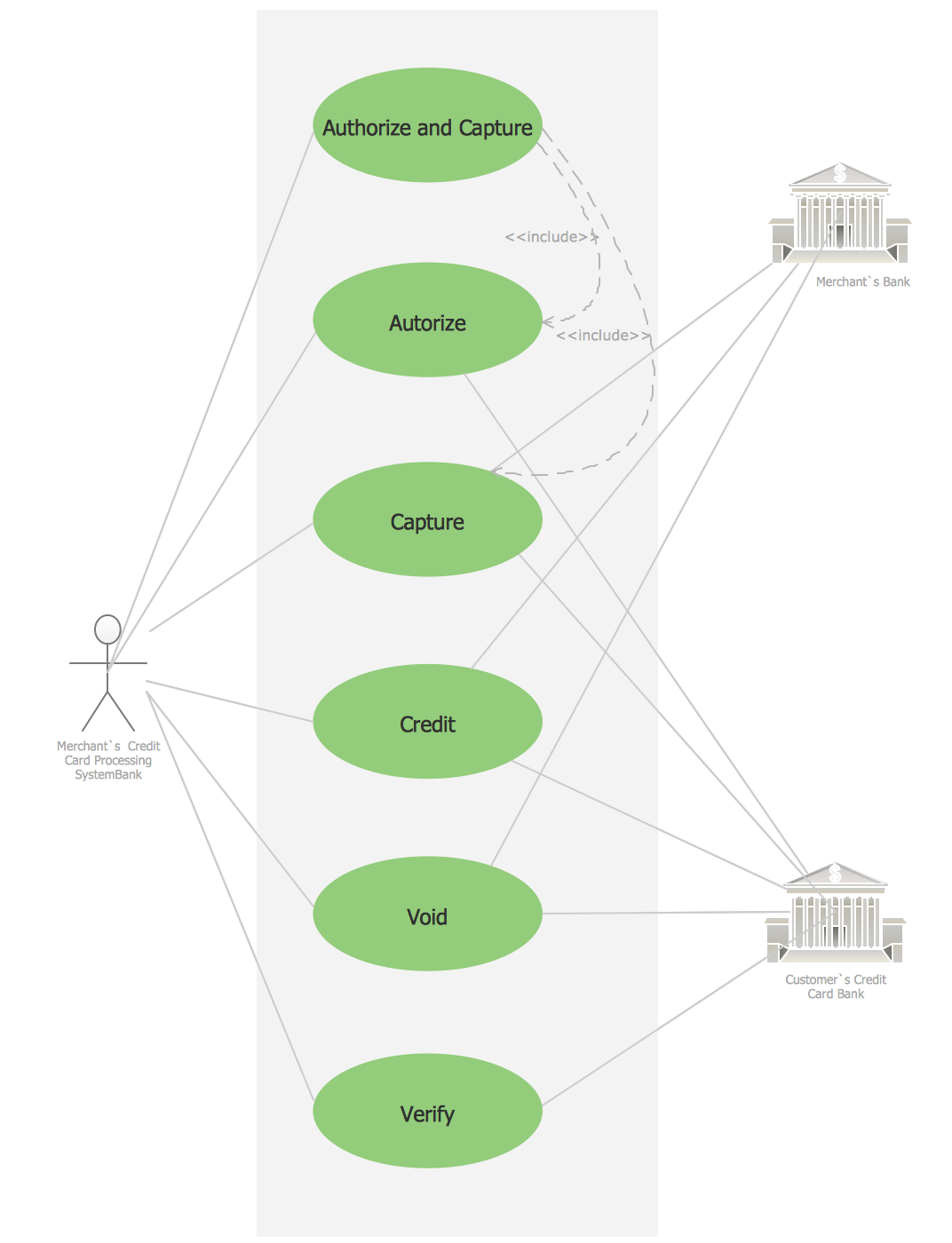
Credit Card Processing System UML Diagram
 Fishbone Diagrams
The Fishbone Diagrams solution extends ConceptDraw DIAGRAM software with the ability to easily draw the Fishbone Diagrams (Ishikawa Diagrams) to clearly see the cause and effect analysis and also problem solving. The vector graphic diagrams produced using this solution can be used in whitepapers, presentations, datasheets, posters, and published technical material.
The vector stencils library "Asia" contains 57 Asian state map contours for drawing thematic and political maps of Asia. Use it for visual representation of geospatial information, statistics and quantitative data.
"Asia is the Earth's largest and most populous continent, located primarily in the eastern and northern hemispheres. ... Countries: 49 (and 5 disputed)." [Asia. Wikipedia]
The state map contours example "Asia - Vector stencils library" was created using the ConceptDraw PRO diagramming and vector drawing software extended with the Continent Maps solution from the Maps area of ConceptDraw Solution Park.
Asia

Central Asia

South Asia

East Asia

Southeast Asia

Afghanistan

Armenia

Azerbaijan

Bahrain

Bangladesh

Bhutan

Brunei

Burma (Myanmar)
-asia---vector-stencils-library.png--diagram-flowchart-example.png)
Cambodia

China

Cyprus

Georgia

India

Indonesia

Iran

Iraq

Israel

Japan

Jordan

Kazakhstan

Kuwait

Kyrgyzstan

Laos

Lebanon

Malaysia

Maldives

Mongolia

Nepal

North Korea

Oman

Pakistan

Papua New Guinea

Philippines

Qatar

Russia (Asia)
-asia---vector-stencils-library.png--diagram-flowchart-example.png)
Saudi Arabia

Singapore

South Korea

Sri Lanka

Syria

Taiwan

Tajikistan

Thailand

Turkey

Turkmenistan

United Arab Emirates

Uzbekistan

Vietnam

Yemen

Aral Sea

Caspian Sea

Lake Balkhash

The vector stencils library "Asia" contains 47 country contours for drawing thematic maps of Asia.
Use it in your spatial infographics for visual representation of geospatial information, statistics and quantitative data in the ConceptDraw PRO diagramming and vector drawing software extended with the Spatial Infographics solution from the area "What is Infographics" of ConceptDraw Solution Park.
Use it in your spatial infographics for visual representation of geospatial information, statistics and quantitative data in the ConceptDraw PRO diagramming and vector drawing software extended with the Spatial Infographics solution from the area "What is Infographics" of ConceptDraw Solution Park.
Asia

Afghanistan

Armenia

Azerbaijan

Bahrain

Bangladesh

Bhutan

Brunei

Burma (Myanmar)
-asia---vector-stencils-library.png--diagram-flowchart-example.png)
Cambodia

China

Cyprus

Georgia

India

Indonesia

Iran

Iraq

Israel

Japan

Jordan

Kuwait

Kazakhstan

Kyrgyzstan

Laos

Lebanon

Malaysia

Mongolia

Nepal

North Korea

Oman

Pakistan

Papua New Guinea

Philippines

Qatar

Saudi Arabia

Singapore

South Korea

Sri Lanka

Syria

Tajikistan

Thailand

Turkey

Turkmenistan

United Arab Emirates

Uzbekistan

Vietnam

Yemen

- Geo Map - Asia - United Arab Emirates
- Asian Map Simple Drawing With Color
- How To Draw A Simple Map Of Pakistan Step By Step
- How To Draw A Simple South Korea Map
- Simple Philippine Map Drawing
- Draw Simple World Map
- How To Draw Myanmar Country Map Step By Step Simple
- Simple Map Of The World
- Geo Map - Asia
- Geo Map - Asia - Mongolia | Geo Mapping Software Examples ...
- Geo Mapping Software Examples - World Map Outline | Geo Map ...
- Pakistqn Map Drawing
- World Continents Map | Map of Continents | Continents and Oceans ...
- Geo Map - Asia - South Korea
- Asia Continents Of World Map
- India Map Drawing Images
- Picture Graph | How to Draw a Line Graph | Continent Maps | How ...
- Geo Map - Asia - United Arab Emirates | Geo Map - United States of ...
- Geo Map - Asia - Philippines | Geo Map - Asia - Myanmar | Geo Map ...
- Geo Map - Asia - India | Geo Mapping Software Examples - World ...