This Water cycle diagram example was drawn using the ConceptDraw PRO diagramming and vector graphics software extended with the clipart libraries Geography and Weather.
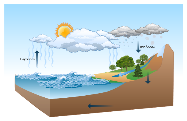
"The water cycle, also known as the hydrologic cycle or the H2O cycle, describes the continuous movement of water on, above and below the surface of the Earth. The mass water on Earth remains fairly constant over time but the partitioning of the water into the major reservoirs of ice, fresh water, saline water and atmospheric water is variable depending on a wide range of climatic variables. The water moves from one reservoir to another, such as from river to ocean, or from the ocean to the atmosphere, by the physical processes of evaporation, condensation, precipitation, infiltration, runoff, and subsurface flow. In so doing, the water goes through different phases: liquid, solid (ice), and gas (vapor)." [Water cycle. Wikipedia]
This water cycle diagram example is included in the Nature solution from the Illustration area of ConceptDraw Solution Park.
Vector illustration
Geo Map of Americas

- Geo Map of Americas | How To Draw Mountain And Raining Rivers
- Water cycle diagram | Drawing Illustration | Nature Clipart and ...
- River Clipart
- Rivers Clipart
- Clipart Of A River
- Clipart Of A River Flowing To The Sea
- Free Clip Art River Flowing To The Sea
- River Illustration Png
- Rain Flow Clipart
- Water cycle diagram | Beauty in nature Illustrations and Clipart ...
- River Water Png
- Water cycle diagram | Drawing a Nature Scene | Drawing Illustration ...
- Clip Art Elements Of Nature
- Nature River Diagrams
- Beauty in nature Illustrations and Clipart | Weather - Vector stencils ...
- Rain Cycle Diagram
- Water cycle diagram | Drawing a Nature Scene | Beauty in nature ...
- Water cycle diagram | Sea Cycle Clipart
- Water cycle diagram | Clipart On Water Vapor
- Design elements - Weather | Nature Clipart and Illustrations ...