Geo Map — Africa — Tanzania

Geo Map - Africa - Uganda
"East Africa or Eastern Africa is the easterly region of the African continent, variably defined by geography or geopolitics. In the UN scheme of geographic regions, 20 territories constitute Eastern Africa:
- Tanzania, Kenya, Uganda, Rwanda and Burundi – in Southeast Africa included in the African Great Lakes region and are members of the East African Community (EAC). Burundi and Rwanda are sometimes considered part of Central Africa.
- Djibouti, Eritrea, Ethiopia and Somalia – collectively known as the Horn of Africa.
- Mozambique and Madagascar – often considered part of Southern Africa. Madagascar has close cultural ties to Southeast Asia and the islands of the Indian Ocean.
- Malawi, Zambia and Zimbabwe – often included in Southern Africa, and formerly of the Central African Federation.
- Comoros, Mauritius and Seychelles – small island nations in the Indian Ocean.
- Réunion and Mayotte – French overseas territories also in the Indian Ocean.
- South Sudan – newly independent from Sudan." [East Africa. Wikipedia]
South Sudan has become independent on July 9, 2011. Sudan and South Sudan are shown with the new international border between them.
This East Africa political map was redesigned using the ConceptDraw PRO diagrammin and vector drawing software from the Wikimedia Commons file: Afryka Wschodnia.png.
[commons.wikimedia.org/ wiki/ File:Afryka_ Wschodnia.png]
The example "East Africa - Political map" is included in the Continent Maps solution from the Maps area of ConceptDraw Solution Park.
Political map - East Africa

Geo Map - Africa - Chad

Geo Map - Africa - Congo
Geo Map - Africa - Nigeria
Geo Map - Africa - Burkina Faso
Geo Map - Africa - Djibouti
Geo Map - Africa - Morocco

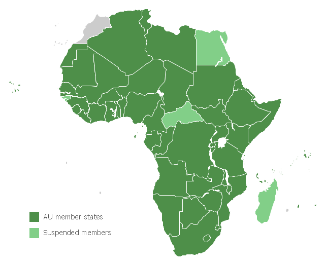
Map of Africa, with African Union member states in dark green and states with suspended membership in light green.
"The African Union (AU) is a union consisting of 54 African states. The only all-African state not in the AU is Morocco.
The most important decisions of the AU are made by the Assembly of the African Union, a semi-annual meeting of the heads of state and government of its member states. The AU's secretariat, the African Union Commission, is based in Addis Ababa, Ethiopia." [African Union. Wikipedia]
This political map example was redesigned from the Wikimedia Commons file: Map of the African Union with Suspended States.svg.
[commons.wikimedia.org/ wiki/ File:Map_ of_ the_ African_ Union_ with_ Suspended_ States.svg]
The example "Map of the African Union with Suspended States" was created using the ConceptDraw PRO diagramming and vector drawing software extended with the Continent Map solution from the Maps area of ConceptDraw Solution Park.
Political map - African Union
- Drawing Of A Map Of East Africa
- Maghreb countries - Political map | Map Of The Maghreb
- Political Map Of West Africa
- Maghreb countries - Political map | Maghreb countries - Political ...
- Maghreb countries - Political map | Continent Maps | Geo Map ...
- Political Map Of East Africa Diaram
- Maghreb countries - Political map | West Africa countries ...
- East Africa - Political map | West Africa countries | Geo Map - Africa ...
- Geo Map - Africa - Morocco | Maghreb countries - Political map | Geo ...
- Geo Map - Africa - Madagascar | East Africa - Political map | Geo ...