The vector clipart library Geography contains 14 images of geographical features: ocean, forest, river, lake, waterfall, mountains, ravine, volcano, desert, hills, iceberg, trees.
Use the design elements library Geography to draw illustrations with landform images using the ConceptDraw PRO diagramming and vector drawing software.
"A landform in the earth sciences comprises a geomorphological unit, and is largely defined by its surface form and location in the landscape. As part of the terrain a landform is an element of topography. Landform elements also include land such as hills, mountains, plateaus,canyons,valleys, seascape and oceanic waterbody interface features such as bays, peninsulas, seas and so forth, including sub-aqueous terrain features such as mid-ocean ridges, volcanoes,and the great ocean basins." [Landform. Wikipedia]
This landscape illustration example is included in the Nature solution from the Illustration area of ConceptDraw Solution Park.
Vector illustration

The vector stencils library "Geography" contains 14 clipart images of natural landscapes and water features for drawing illustrations.
"A natural landscape is a landscape that is unaffected by human activity. A natural landscape is intact when all living and nonliving elements are free to move and change. The nonliving elements distinguish a natural landscape from a wilderness. A wilderness includes areas within which natural processes operate without human interference, but a wilderness must contain life. As implied, a natural landscape may contain either the living or nonliving or both." [Natural landscape. Wikipedia]
The clip art example "Geography - Vector stencils library" was created using the ConceptDraw PRO diagramming and vector drawing software extended with the Nature solution from the Illustration area of ConceptDraw Solution Park.
www.conceptdraw.com/ solution-park/ illustrations-nature
Ocean

Forest

River

Lake

Waterfall

Mountains

Mountain

Ravine

Volcano

Desert

Hills

Iceberg

Conifer tree

Tree

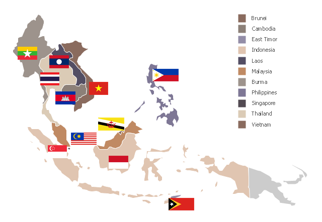
"Southeast Asia or Southeastern Asia is a subregion of Asia, consisting of the countries that are geographically south of China, east of India, west of New Guinea and north of Australia. The region lies near the intersection of geological plates, with heavy seismic and volcanic activity. Southeast Asia consists of two geographic regions:
(1) Maritime Southeast Asia, comprising Philippines, East Malaysia, East Timor, Indonesia, Brunei, and Singapore.
(2) Mainland Southeast Asia, also known as Indochina, comprising Cambodia, Laos, Myanmar (Burma), Thailand, West Malaysia and Vietnam." [Southeast Asia. Wikipedia]
This political map sample was redesigned from the Wikimedia Commons file: Suresteasia324.jpg. [commons.wikimedia.org/ wiki/ File:Suresteasia324.jpg]
This file is licensed under the Creative Commons Attribution-Share Alike 3.0 Unported license. [creativecommons.org/ licenses/ by-sa/ 3.0/ deed.en]
The example "Southeast Asia - Political map" was created using the ConceptDraw PRO diagramming and vector drawing software extended with the Continent Maps solution from the Maps area of ConceptDraw Solution Park.
Political map - Southeast Asia
- Ravine Clipart
- Draw Mountains
- Design Elements Geography To Draw Illustrations
- Nature Drawings - How to Draw | Building Drawing Design Element ...
- Geography - Vector stencils library | How to Draw a Natural ...
- Landscape Designs For Volcano Clipart
- Nature | How to Draw a Natural Landscape | Geography - Vector ...
- Design elements - Geography | How to Draw a Natural Landscape ...
- Elements Of Nature River Ocean Mountain Hill Forest Volcano
- Design elements - Geography | Geography - Vector stencils library ...
- How to Draw a Natural Landscape | Design elements - Geography ...
- Drawing Of Mountains Rivers Forests Seas
- Design elements - Geography | How to Draw a Map of North ...
- Lake River The Sea The Ocean Clipart
- Drawing Of River Lake And Waterfall
- Map Software | How to Draw a Natural Landscape | Geo Map - Africa ...
- Rail transport - Design elements | Nature Drawings - How to Draw ...
- Geography - Vector stencils library | How to Draw a Natural ...
- Landforms Mountains Clipart