 Audio, Video, Media
Use it to make professional-looking documents, impressive presentations, and efficient websites with colorful and vivid illustrations and schematics of digital audio, video and photo gadgets and devices, audio video connections and configurations, S Video connection, HD and 3D television systems, home entertainment systems, Closed-circuit television (CCTV) surveillance systems. All audio video schematics, drawings and illustrations designed in ConceptDraw PRO are professional looking, clear and understandable for all thanks to applying the most commonly used standards of designations, and are effective for demonstrating in front of a small audience and on the big screens.
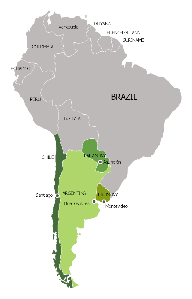
"Southern Cone (Spanish: Cono Sur, Portuguese: Cone Sul) is a geographic region composed of the southernmost areas of South America, south of and around the Tropic of Capricorn. Traditionally, it covers Argentina, Chile and Uruguay, bounded on the west by the Pacific Ocean, and south to the junction between the Pacific and Atlantic Oceans, which is the closest continental area of Antarctica (1000 km). In terms of social and political geography, the Southern Cone comprises Argentina, Chile, Paraguay, Uruguay, Southern Brazil and the Brazilian state of São Paulo.
High life expectancy, the highest Human Development Index of Latin America, high standard of living, significant participation in the global markets and the emerging economy of its members make the Southern Cone the most prosperous macro-region in South America." [Southern Cone. Wikipedia]
This political map sample was redesigned from the Wikimedia Commons file: Map of South America (Cono sud).png. [commons.wikimedia.org/ wiki/ File:Map_ of_ South_ America_ (Cono_ sud).png]
This file is licensed under the Creative Commons Attribution-Share Alike 3.0 Unported license. [creativecommons.org/ licenses/ by-sa/ 3.0/ deed.en]
The example "Southern Cone - Political map" was created using the ConceptDraw PRO diagramming and vector drawing software extended with the Continent Maps solution from the Maps area of ConceptDraw Solution Park.
Political map - Southern Cone
The vector stencils library "ABC" contains 87 symbols of English letters, numerals and punctuation marks.
"An alphabet is a standard set of letters (basic written symbols or graphemes) which is used to write one or more languages based on the general principle that the letters represent phonemes (basic significant sounds) of the spoken language. This is in contrast to other types of writing systems, such as syllabaries (in which each character represents a syllable) and logographies (in which each character represents a word, morpheme, or semantic unit). ...
There are dozens of alphabets in use today, the most popular being the Latin alphabet (which was derived from the Greek). Many languages use modified forms of the Latin alphabet, with additional letters formed using diacritical marks. ...
Alphabets are usually associated with a standard ordering of their letters. This makes them useful for purposes of collation, specifically by allowing words to be sorted in alphabetical order. It also means that their letters can be used as an alternative method of "numbering" ordered items, in such contexts as numbered lists." [Alphabet. Wikipedia]
The symbols example "ABC" was created using the ConceptDraw PRO diagramming and vector drawing software extended with the Artwork solution from the Illustration area of ConceptDraw Solution Park.
www.conceptdraw.com/ solution-park/ illustrations-artwork


)
-abc.png--diagram-flowchart-example.png)


- Star Topology Examples Real Life
- Real Life Applications Of Hybrid Topology Answers
- Example Of Star Topology In Real Life
- Example Of Bus Topology In Real Life
- Real Life Example Of Mesh Topology
- Example Of Bus Topology Wan In Real Life
- Real Time Example Of Star Wired Ring Topology
- How To Use Tree Topology In Real Life
- Real Time Example Of Bus Topology
- In Real Life Where We Can Use The Bus Topology
- Star Network Topology | Metropolitan area networks (MAN ...
- Real Life Application Of Star Topology In Ppt
- Types Of Topology With Real Life Example
- Explain The Mesh Topology With Diagram And Real Life Example
- Bus Topology Real Time Example
- Ring Topology Real Time Example
- Mesh Topology Real Time Example
- Topology Diagrams With Real Time Example
- Wide area network (WAN) topology. Computer and Network Examples
- Topology In Real Life