HelpDesk
How to Create a Directional Map

 Directional Maps
Directional Maps solution extends ConceptDraw DIAGRAM software with templates, samples and libraries of vector stencils for drawing the directional, location, site, transit, road and route maps, plans and schemes.
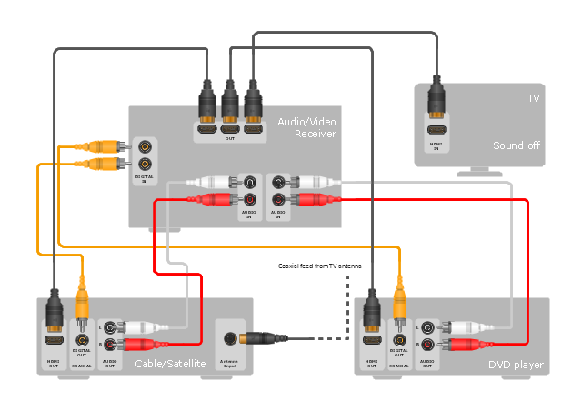
"Surround sound is a technique for enriching the sound reproduction quality of an audio source with additional audio channels from speakers that surround the listener (surround channels), providing sound from a 360° radius in the horizontal plane (2D) as opposed to "screen channels" (centre, [front] left, and [front] right) originating only from the listener's forward arc.
Surround sound is characterized by a listener location or sweet spot where the audio effects work best, and presents a fixed or forward perspective of the sound field to the listener at this location. The technique enhances the perception of sound spatialization by exploiting sound localization; a listener's ability to identify the location or origin of a detected sound in direction and distance. Typically this is achieved by using multiple discrete audio channels routed to an array of loudspeakers.
There are various surround sound based formats and techniques, varying in reproduction and recording methods along with the number and positioning of additional channels." [Surround sound. Wikipedia]
The hookup diagram example "Hook up drawing - Home entertainment system with surround sound" was created using the ConceptDraw PRO diagramming and vector drawing software extended with the Audio and Video Connectors solution from the Engineering area of ConceptDraw Solution Park.
Hookup diagram
ConceptDraw Arrows10 Technology
Bubble diagrams in Landscape Design with ConceptDraw DIAGRAM

- Directional Map Drawing Software
- 3d Drawing Maps
- Directional Maps | Directions Maps | Conference centre location ...
- Software Drawing Directional Map
- Map Directions | 2D Directional map - Template | Directional Maps ...
- Building Drawing Software for Design Site Plan | Directions Map ...
- How To Create A 2d Location Map
- Directions Maps | Directional Maps | 3d Neighborhood Plan Drawing
- Map Directions | Directions Map | Maps and Directions | A Drawing ...
- Map Directions | How to draw Metro Map style infographics? (New ...
- 2D Directional map - Template | Directions Map | Map Directions ...
- Directional Maps | Directions Map | Maps Driving Directions ...
- Direction Map Templates
- Directional Maps | How to Create a Directional Map Using ...
- Design elements - 3D directional maps | Map Directions | Maps and ...
- Direction Map Drawing
- Map Directions | Directions Map | Road Transport - Design Elements ...
- Directional Maps | Map Directions | Design elements - 3D directional ...
- 2D Directional map - Template | Map Directions | Directional Maps ...
- Directions Maps