
Example 1. Continents and Oceans Map - Southeast Asia Map
Continent Maps Solution offers you the great opportunities for Continents and Oceans Map. It's enough to look at the gallery of Continent Maps Solution libraries to make sure that this is true.

Example 2. Continent Maps Solution in ConceptDraw STORE
Don't forget also look over the numerous collection of samples and templates included in Continent Maps Solution and available from ConceptDraw STORE. All samples are excellent examples and also the beautiful start for your own continents and oceans map.

Example 3. Continent Map - Ranks US States by Peacefulness
The samples you see on this page were created in ConceptDraw DIAGRAM software using the Continent Maps solution. Any Continents and Oceans Map created in ConceptDraw DIAGRAM successfully demonstrates solution's capabilities and professional results you can achieve. An experienced user spent 10 minutes creating every of these samples.
Use the tools of the Continent Maps solution to draw your own Continents and Oceans Map quickly and effectively in ConceptDraw DIAGRAM software.
All source documents are vector graphic documents. They are available for reviewing, modifying, or converting to a variety of formats (PDF file, MS PowerPoint, MS Visio, and many other graphic formats) from the ConceptDraw STORE. The Continent Maps Solution is available for all ConceptDraw DIAGRAM or later users.
SEVEN RELATED HOW TO's:
Papua New Guinea, officially named the Independent State of Papua New Guinea, is a country in Oceania that occupies the eastern half of the island of New Guinea (the western portion of the island is a part of the Indonesian provinces of Papua and West Papua) and numerous offshore islands.
The vector stencils library Papua New Guinea contains contours for ConceptDraw DIAGRAM diagramming and vector drawing software. This library is contained in the Continent Maps solution from Maps area of ConceptDraw Solution Park.
Picture: Geo Map - Asia - Papua New Guinea
Related Solution:
Maine is a state in the New England region of the northeastern United States, bordered by the Atlantic Ocean to the east and south; New Hampshire to the west; the Canadian provinces of Quebec to the northwest; and New Brunswick to the northeast.
The vector stencils library Maine contains contours for ConceptDraw DIAGRAM diagramming and vector drawing software. This library is contained in the Continent Maps solution from Maps area of ConceptDraw Solution Park.
Picture: Geo Map — USA — Maine
Related Solution:
Kyrgyzstan, officially the Kyrgyz Republic, is a country located in Central Asia.
The vector stencils library Kyrgyzstan contains contours for ConceptDraw DIAGRAM diagramming and vector drawing software. This library is contained in the Continent Maps solution from Maps area of ConceptDraw Solution Park.
Picture: Geo Map - Asia - Kyrgyzstan
Related Solution:
ConceptDraw DIAGRAM is idea to draw the geological maps of World from the pre-designed vector geo map shapes.
Picture: Geo Map - World
Related Solution:
ConceptDraw DIAGRAM diagramming and vector drawing software enhanced with Continent Maps Solution from the Maps Area is the best for drawing geographic, topography, political, and many other kinds of maps for any of seven earth continents and also world continents map of any detailing.
Picture: World Continents Map
Related Solution:
A continent is one of several very large landmasses on Earth. ConceptDraw DIAGRAM diagramming and vector drawing software offers the unique Continent Maps Solution from the Maps Area which is indispensable for drawing the map of continents of the Earth.
Picture: Map of Continents
Related Solution:
Every day many of people confront in their work with necessity of drawing various continent maps. Specially for these people was developed the Continent Maps Solution and included to the Maps Area of ConceptDraw Solution Park. Thanks to it you can design any Continent Map quick and easy.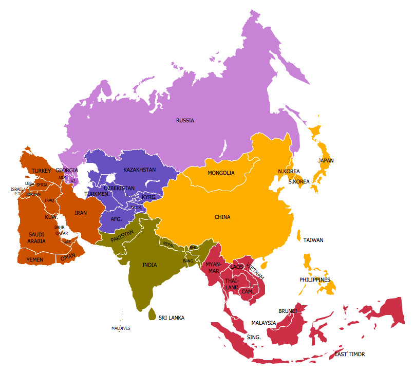
Picture: Continent Map
Related Solution:

