Map of England
England is included into the United Kingdom of Great Britain. It borders with Wales to the west and Scotland to the north. The Irish Sea is to the north-western part of England and there is also the Celtic Sea, lying to the south-west. This country is separated from the continental Europe by the English Channel to the south and the North Sea to the east. The is a five-eighths of the island of Great Britain belonging to England, which are the central and the southern parts. It also includes over 100 smaller islands, for example, the Isle of Wight and the Isles of Scilly.
England is mostly covered with the low hills and plains, mainly in the central and the southern part of England. Although, there are uplands in the north, such as the mountainous Pennines and the Lake District. The capital of this country is London, having the largest metropolitan area in both the European Union and the United Kingdom. The population of this country is over 53 million, comprising 84% of the total population of the United Kingdom of Great Britain. The most of the inhabitants are concentrated around London, the Midlands, the South East, the North West, Yorkshire and the North east.
The name "England" originated from the name “Englaland” in Old English, having the meaning of the "land of the Angles”, who were one of the Germanic tribes, settled there during the Early Middle Ages, coming from the Angeln peninsula in the Bay of Kiel area, which is nowadays a territory of a German state of Schleswig-Holstein, in the Baltic Sea. Literally, the meaning of the name of the country was "the land inhabited by the English", and its modern spelling as “England” was first used in 1538. An alternative name for this country is “Albion”, originally referred to the entire island of the United Kingdom of Great Britain.
The basic political system in England is a parliamentary system as well as a constitutional monarchy. England is governed directly by the Parliament of the United Kingdom, having 532 Members of Parliament (MPs) for constituencies in England, out of the 650. Nowadays, the United Kingdom of Great Britain is still a member of the European Union. The so-called “devolution” took place in Great Britain, resulting in the other countries of the United Kingdom, such as Northern Ireland, Scotland and Wales got their rights to have their own devolved parliament/assemblies for local issues.
As it was mentioned before, geographically England includes both the southern and the central two-thirds of the island of the United Kingdom of Great Britain, including also the offshore islands, such as the Isles of Scilly and the Isle of Wight. This country is bordered by two other countries of the United Kingdom, which are: Wales to the west and Scotland to the north. England is separated from France by only a 34-kilometre sea gap, as the two countries are connected by the channel built in 1994 known as Channel Tunnel. There are also a few shores on the North Sea, Atlantic Ocean and Irish Sea, belonging to England.
The ports of England are in London, Newcastle and Liverpool, lying on the tidal rivers Tyne, Mersey and Thames. Severn is the longest river in England, being 350 kilometres long. However, the longest river, which is all entirely in England, is the Thames, being 346 kilometres in its length. There are also very many lakes in this country, including the largest one, which is Windermere within the so-called “Lake District”. The oldest range of mountains in the country is the Pennines, also known as the "backbone of England". England is rich in coal, as well as limestone and sandstone. The Pennine landscape is high moorland in upland areas, indented by the fertile valleys of the region's rivers, containing the three national parks, which are the Peak District, the Northumberland and the Yorkshire Dales.
The highest point in England is at 978 metres above sea level, known as a Scafell Pike in Cumbria. There are also the Cheviot Hills, straddling the border between two countries – Scotland and England. To the south of the Pennines, there are the English Lowlands, which consist of the green rolling hills, including the South Downs, the Cotswold Hills, the Chiltern ones as well as the North Downs. Two more national parks are Exmoor and Dartmoor, covering the territory of 954 square kilometres.
The largest urban area in England is so-called the “Greater London Urban Area”, being one of the busiest cities in the world as well as being considered as a global city, having a population larger than other countries in the United Kingdom, besides from England itself. Other urban areas are located in the English Midlands in the northern part of England. The largest cities of this country are Manchester, Liverpool, Sheffield, Birmingham, Leeds, Newcastle, Nottingham and Bradford.
Thus, there are about 2553379 living in the Greater Manchester Urban Area, mainly in the large cities, such as Manchester, Bolton, Salford, Oldham and Stockport. 2440986 people live in the West Midlands Urban Area, mainly in Birmingham, Wolvehampton, Dudley, Aldridge and Walsall. About 1777934 can be found in the West Yorkshire Urban Area (Bradford, Leeds, Wakefield, Huddersfield and Halifax). About 864122 are inhabiting the Liverpool Urban Area, living mainly in St. Helens, Liverpool, Huyton-with-Roby and Bootle. There are over 855000 living in the South Hampshire region, mainly in Portsmouth, Southampton, Fareham, Gosport, Horndean and Havant towns. The most populous towns in Tyneside region are Newcastle, South Shields, Jarrow, North Shields and Gateshead. The Nottingham Urban Area is known for its big towns and cities, such as Long Easton, Beeston, Nottingham and Carlton, where about 730000 people live. In Sheffield Urban Area there are about 685000 people living and in the Bristol Urban Area there are over 615000 of inhabitants, located in Kingswood, Bristol, Stroke Gifford, Mangotsfield and other towns.
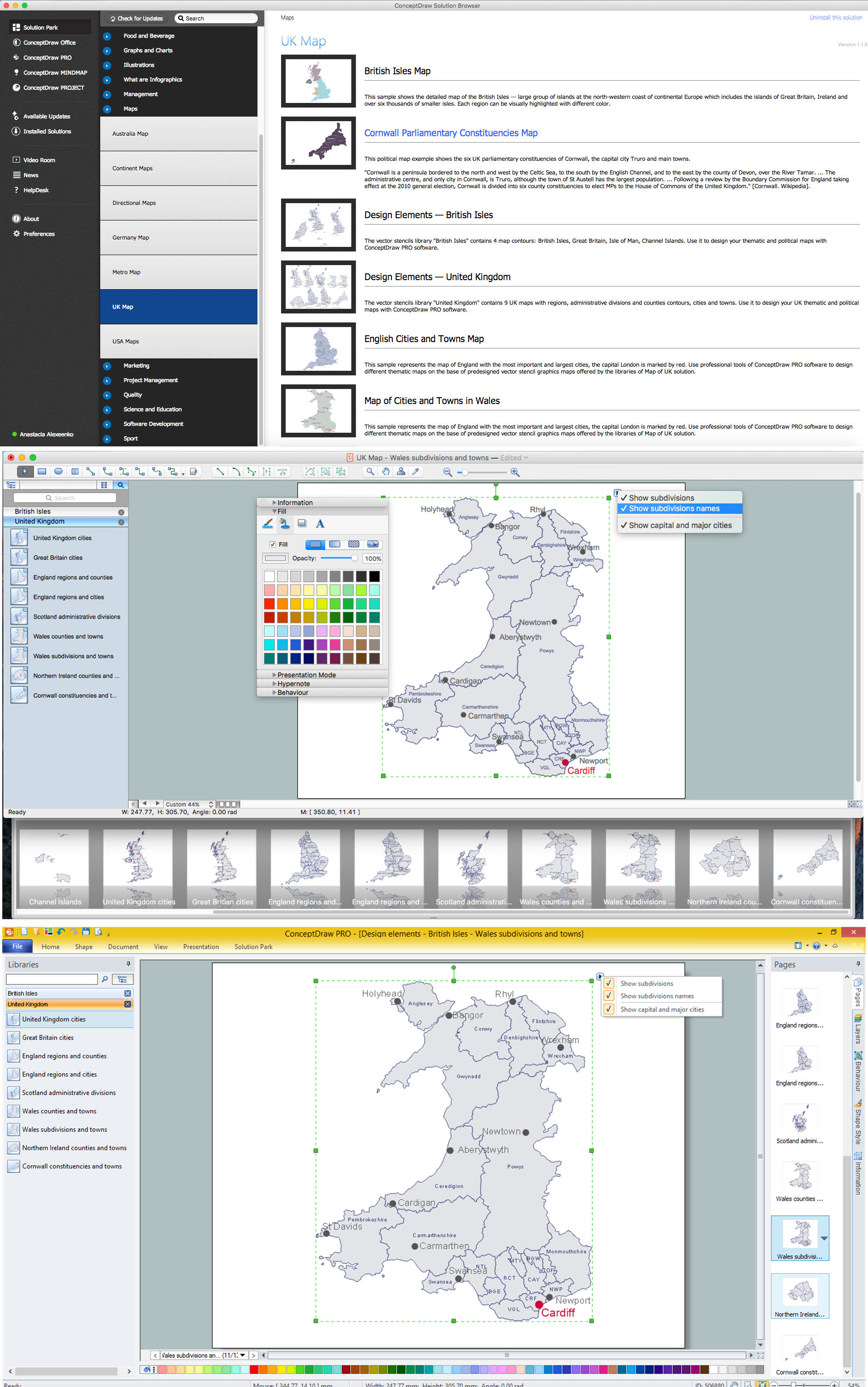
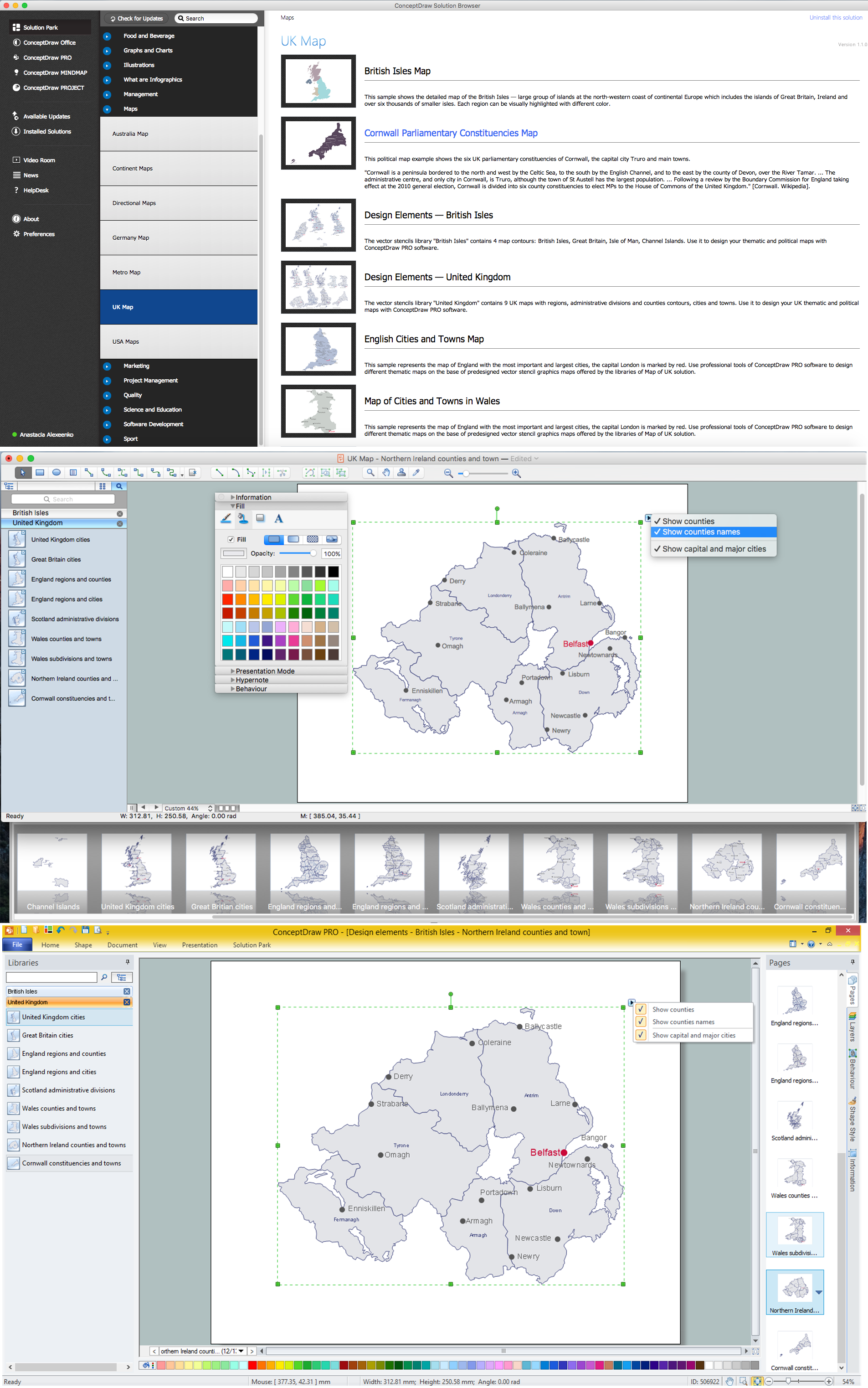
Design of various maps, including the Map of England is usually complex and labor-intensive process. But now we have a possibility to create UK maps fast and easy thanks to the ConceptDraw DIAGRAM diagramming and vector drawing software enhanced with Map of UK Solution from the Maps Area of ConceptDraw Solution Park.

Example 1. Map of England — Cities and Towns
Once you want to mention all of the big cities, as well as the small ones, of England on your own map, then you might find the “UK Solution” from the “Maps Area” of the “ConceptDraw Solution Park” from this site very useful. Try the Map of UK Solution with two stencil libraries full of the ready-to-use maps for making your own using ConceptDraw DIAGRAM software.


All objects from these libraries of Map of UK solution were specially designed to give you the opportunity to create in a few minutes the maps for all UK countries, including of course the map of England. Besides, all these objects are vector, so you can resize them without loss of quality, change their color filling to make your map yet more interesting, bright and attractive.

Example 2. Map of UK Solution in ConceptDraw STORE
Map of UK solution provides also variety of examples and samples of various UK maps, all they are offered in ConceptDraw STORE. You can use any of them as is or change for your needs and then successfully use in various presentations and publications.

Example 3. Map of English Regions
The samples you see on this page were created in ConceptDraw DIAGRAM software using the tools of the Map of UK solution and show the detailed maps of England. An experienced user spent 10-15 minutes creating each of these maps.
Use the Map of UK solution for ConceptDraw DIAGRAM software to design your own map of England quick, easy and effective, and then successfully use it in your life or work activity.
All source documents are vector graphic documents. They are available for reviewing, modifying, or converting to a variety of formats (PDF file, MS PowerPoint, MS Visio, and many other graphic formats) from the ConceptDraw STORE. The Map of UK Solution is available for all ConceptDraw DIAGRAM users.