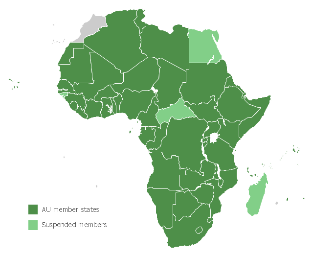
Map of Africa, with African Union member states in dark green and states with suspended membership in light green.
"The African Union (AU) is a union consisting of 54 African states. The only all-African state not in the AU is Morocco.
The most important decisions of the AU are made by the Assembly of the African Union, a semi-annual meeting of the heads of state and government of its member states. The AU's secretariat, the African Union Commission, is based in Addis Ababa, Ethiopia." [African Union. Wikipedia]
This political map example was redesigned from the Wikimedia Commons file: Map of the African Union with Suspended States.svg.
[commons.wikimedia.org/ wiki/ File:Map_ of_ the_ African_ Union_ with_ Suspended_ States.svg]
The example "Map of the African Union with Suspended States" was created using the ConceptDraw PRO diagramming and vector drawing software extended with the Continent Map solution from the Maps area of ConceptDraw Solution Park.
Political map - African Union
Geo Map - Africa - Tanzania

The vector stencils library Tanzania contains contours for ConceptDraw PRO diagramming and vector drawing software. This library is contained in the Continent Maps solution from Maps area of ConceptDraw Solution Park.
Geo Map - Africa

Vector design elements library Africa contains country map contours, geographical maps, cartograms and thematic maps for ConceptDraw PRO diagramming and vector drawing software. To help visualize the business and thematic information connected with geographic areas, locations or customs.
All ConceptDraw PRO documents are vector graphic files and are available for reviewing, modifying, and converting to a variety of formats: image, HTML, PDF file, MS PowerPoint Presentation, Adobe Flash, MS Visio (.VDX, .VSDX).
Geo Map - Africa - Namibia

The vector stencils library Namibia contains contours for ConceptDraw PRO diagramming and vector drawing software. This library is contained in the Continent Maps solution from Maps area of ConceptDraw Solution Park.
 Continent Maps
Continent Maps solution extends ConceptDraw PRO software with templates, samples and libraries of vector stencils for drawing the thematic maps of continents, state maps of USA and Australia.
UML Business Process

- Geo Map - Africa | Map of the African Union with Suspended States ...
- States Map
- Learn how to create a current state value stream map | Geo Map ...
- Africa flags - Stencils library | East Africa - Political map | Design ...
- Geo Map - Europe - Spain | European country flags - Vector stencils ...
- Information systems in the schools | School and Training Plans ...
- Basic Flowchart Symbols and Meaning | Create Process Flowcharts ...
- Cross-Functional Flowchart | Process Flowchart | Top 5 Android ...
- Sales Process Flowchart. Flowchart Examples | How to Create a ...
- Process Flowchart | Contoh Flowchart | Cross-Functional Flowchart ...
- Basic Flowchart Symbols and Meaning | Process Flowchart ...
- Process Flowchart | Types of Flowchart - Overview | Event-Driven ...
- Audio - Vector stencils library | Video and audio - Vector stencils ...
- Fire safety equipment - Vector stencils library | Safety and Security ...
- Website metrics - Visual dashboard | Website traffic dashboard ...
- 5 Level pyramid model diagram - Information systems types | Design ...
- How to Draw the Different Types of Pie Charts | Ring chart ...
- ERD | Entity Relationship Diagrams, ERD Software for Mac and Win
- Flowchart | Basic Flowchart Symbols and Meaning
- Flowchart | Flowchart Design - Symbols, Shapes, Stencils and Icons
- Flowchart | Flow Chart Symbols
- Electrical | Electrical Drawing - Wiring and Circuits Schematics
- Flowchart | Common Flowchart Symbols
- Flowchart | Common Flowchart Symbols