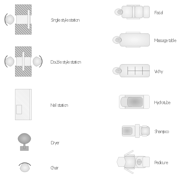
The vector stencils library "Spa" contains 11 symbols of day spa equipment.
"A day spa is a business which provides a variety of services for the purpose of improving health, beauty and relaxation through personal care treatments such as massages and facials. It is different from a beauty salon in that it contains facilities like sauna, pool, steam room and whirlpool that guests may use in addition to their treatment. In contrast, a destination spa offers similar services integrated into packages which include diet, exercise programs, instruction on wellness, life coaching, yoga and accommodations where participants reside for the duration of their stay. A resort-spa may also function as a day spa, if they allow access to patrons who are not guests of the hotel." [Day spa. Wikipedia]
Use the shapes library "Spa" to design equipment layout floor plans of day spa, beauty salon and nail studio using ConceptDraw PRO diagramming and vector drawing software.
The design elements library "Spa" is included in the Gym and Spa Area Plans solution from the Building Plans area of ConceptDraw Solution Park.
www.conceptdraw.com/ solution-park/ building-gym-spa-plans
Spa symbols
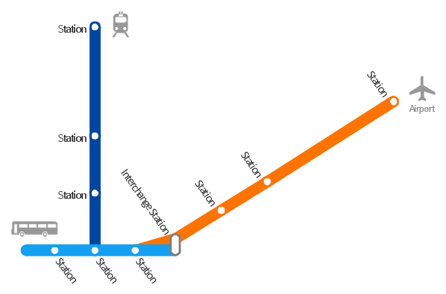
How to draw Metro Map style infographics? Moscow, New York, Los Angeles, London

How to draw Metro Map style infographics? (Moscow)

Subway infographic design elements - software tools

 Metro Map
Metro Map solution extends ConceptDraw PRO software with templates, samples and library of vector stencils for drawing the metro maps, route maps, bus and other transport schemes, or design tube-style infographics.
"A transit map is a topological map in the form of a schematic diagram used to illustrate the routes and stations within a public transport system - whether this be bus lines, tramways, rapid transit, commuter rail or ferry routes. The main components are color coded lines to indicate each line or service, with named icons to indicate stations or stops. ...
There are a growing number of books, websites and works of art on the subject of urban rail and metro map design and use. There are now hundreds of examples of diagrams in an urban rail or metro map style that are used to represent everything from other transit networks like buses and national rail services to sewerage systems and Derbyshire public houses." [Transit map. Wikipedia]
The transportation map template for the ConceptDraw PRO diagramming and vector drawing software is included in the Spatial Infographics solution from the area "What is Infographics" of ConceptDraw Solution Park.
www.conceptdraw.com/ solution-park/ infographics-spatial
Transit map
The vector stencils library "3D directional maps" contains 40 symbols for creating pictorial maps, street maps, locator maps, transit maps, tourist maps with points of interest (POI), road maps and route maps using the ConceptDraw PRO diagramming and vector drawing software.
"Pictorial maps are a category of maps that are also loosely called illustrated maps, panoramic maps, perspective maps, bird’s-eye view maps and Geopictorial maps amongst others. In contrast to the regular road map, Atlas or topographic cartography, pictorial maps depict a given territory with a more artistic rather than technical style. The cartography can be a sophisticated 3-D perspective landscape or a simple map graphic enlivened with illustrations of buildings, people and animals. They can feature all sorts of varied topics like historical events, legendary figures or local agricultural products and cover anything from an entire continent to a college campus. ...
Pictorial maps usually show an area as if viewed from above at an oblique angle. They are not generally drawn to scale in order to show street patterns, individual buildings, and major landscape features in perspective. While regular maps focus on the accurate rendition of distances, pictorial maps enhance landmarks and often incorporate a complex interplay of different scales into one image in order to give the viewer a more familiar sense of recognition." [Pictorial maps. Wikipedia]
The design elements library "3D directional maps" is included in the Directional Maps solution from the Maps area of ConceptDraw Solution Park.
www.conceptdraw.com/ solution-park/ maps-directional
3D pictorial map symbols

- Design elements - Day spa equipment layout plan | Gym and Spa ...
- Design elements - Spa layout plan | Gym floor plan |
- Design elements - Day spa equipment layout plan | Gym and Spa ...
- Design elements - Day spa equipment layout plan | Gym and Spa ...
- Design elements - Day spa equipment layout plan | How To Draw ...
- How To Draw Building Plans | Design elements - Day spa ...
- Gym floor plan
- How To Draw Building Plans | Building Plan Software. Building Plan ...
- How To Draw Building Plans | Gym and Spa Area Plans | Design ...
- Gym equipment layout floor plan | How To Draw Building Plans ...
- Gym and Spa Area Plans | Design elements - Day spa equipment ...
- Day SPA equipment layout plan - Conceptdraw.com
- How To Create Floor Plans - Conceptdraw.com
- Day SPA equipment layout plan
- Design elements - Day spa equipment layout plan | Gym equipment ...
- Gym and Spa Area Plans | How To Draw Building Plans | Design ...
- How To Draw Building Plans | Design elements - Physical training ...
- Design elements - Physical training plan | Design elements - Spa ...
- How To Draw Building Plans | Gym and Spa Area Plans | Design ...
- Gym and Spa Area Plans | Design elements - Physical training plan ...
- ERD | Entity Relationship Diagrams, ERD Software for Mac and Win
- Flowchart | Basic Flowchart Symbols and Meaning
- Flowchart | Flowchart Design - Symbols, Shapes, Stencils and Icons
- Flowchart | Flow Chart Symbols
- Electrical | Electrical Drawing - Wiring and Circuits Schematics
- Flowchart | Common Flowchart Symbols
- Flowchart | Common Flowchart Symbols