Geo Map - Asia - Philippines

Use the Continent Maps solution and Philippines library to draw thematic maps, geospatial infographics and vector illustrations. This solution to help visualize the business and thematic information connected with geographic areas, locations or customs; for your business documents, presentations and websites.
Continent Map
Geo Map — Europe — Greece

The vector stencils library Greece contains contours for ConceptDraw DIAGRAM diagramming and vector drawing software. This library is contained in the Continent Maps solution from Maps area of ConceptDraw Solution Park.
How To Do A Mind Map In PowerPoint
 Maps
Maps
This solution extends ConceptDraw DIAGRAM.4 with the specific tools necessary to help you draw continental, directional, road, or transit maps, to represent international, business, or professional information visually.
Geo Map - Africa - Congo DRC

The vector stencils library Congo DRC contains contours for ConceptDraw DIAGRAM diagramming and vector drawing software. This library is contained in the Continent Maps solution from Maps area of ConceptDraw Solution Park.
Geo Mapping Software Examples - World Map Outline

Geo Map — United States of America Map

ConceptDraw is idea to draw the geological map of the United States of America from the pre-designed vector geo map shapes.
Each map is scaled, with the option to add further levels of detail - county borders, their names, capitals and major cities can be shown or hidden using the action menu for each state map. ConceptDraw DIAGRAM gives you full control over map size, shading, color fills and alignment.
Use the Continent Maps solution for easy drawing professional looking geological maps, thematic maps, geospatial infographics and vector illustrations for your business documents, presentations and websites.
Types of Map - Overview

Geo Map - South America - Paraguay

The vector stencils library Paraguay contains contours for ConceptDraw DIAGRAM diagramming and vector drawing software. This library is contained in the Continent Maps solution from Maps area of ConceptDraw Solution Park.
Geo Map - USA - New York

The vector stencils library New York contains contours for ConceptDraw DIAGRAM diagramming and vector drawing software. This library is contained in the Continent Maps solution from Maps area of ConceptDraw Solution Park.
Geospatial Data
Map of Germany

Emergency Plan


"A thematic map is a type of map or chart especially designed to show a particular theme connected with a specific geographic area. ...
A thematic map is a map that focuses on a specific theme or subject area, whereas in a general map the variety of phenomena - geological, geographical, political - regularly appear together. ...
Thematic maps emphasize spatial variation of one or a small number of geographic distributions. These distributions may be physical phenomena such as climate or human characteristics such as population density and health issues. ...
Thematic map are sometimes referred to as graphic essays that portray spatial variations and interrelationships of geographical distributions. Location, of course, is important to provide a reference base of where selected phenomena are occurring. ...
Thematic maps serve three primary purposes.
First, they provide specific information about particular locations.
Second, they provide general information about spatial patterns.
Third, they can be used to compare patterns on two or more maps." [Thematic map. Wikipedia]
The vector stencils library "Thematic maps" contains 7 continent map contours for creating the thematic maps of geographic regions displaying the metric values by countries, states and territories marked by different colors.
Use the design elements library "Thematic maps" to create spatial dashboards using the ConceptDraw PRO diagramming and vector drawing software for your Spatial Intelligence and Location Intelligence business practice.
The example "Design elements - Thematic maps" is included in the Spatial Dashboard solution from the area "What is a Dashboard" of ConceptDraw Solution Park.
Thematic map templates

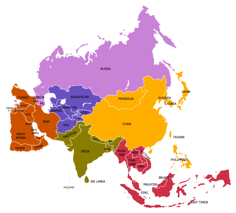
- Design elements - Asia | Geo Map - Asia | Continent Maps | Asian ...
- How To Do A Mind Map In PowerPoint | Geo Map - Asia | Positioning ...
- Geo Map - Asia - Mongolia | Geo Map - Africa - Senegal | How to ...
- Languages of South America - Thematic map | Europe thematic map ...
- Emergency Plan | Blank Map Of Asia
- Geo Map - Asia - India | | | India
- Geo Mapping Software Examples - World Map Outline | World ...
- Geo Map - Asia - Philippines | Emergency Plan | Asia - Vector ...
- Geo Map - Asia - Philippines | Bar Diagrams for Problem Solving ...
- Geo Map - Asia - Philippines | Asia - Vector stencils library ...
- Geo Map - Asia - Philippines | Asia - Vector stencils library ...
- 7 Continents Map
- Geo Map - Asia - Philippines
- Geo Map - Asia - Philippines | How To Create Restaurant Floor Plan ...
- Design elements - Thematic maps | Geo Map - Asia - Philippines ...
- Design elements - Thematic maps | Geo Map - Asia - Singapore ...
- Map Design Elements Vector
- How to Support Your Mind Map with Visual Elements | Subway ...
- Geo Map - Asia - Philippines | Geo Map - Asia - Turkmenistan ...
- How to Draw a Map of North America Using ConceptDraw PRO ...
- ERD | Entity Relationship Diagrams, ERD Software for Mac and Win
- Flowchart | Basic Flowchart Symbols and Meaning
- Flowchart | Flowchart Design - Symbols, Shapes, Stencils and Icons
- Flowchart | Flow Chart Symbols
- Electrical | Electrical Drawing - Wiring and Circuits Schematics
- Flowchart | Common Flowchart Symbols
- Flowchart | Common Flowchart Symbols