Types of Map - Overview

Brilliant Examples of Infographics Map, Transport, Road
 Directional Maps
Directional Maps solution extends ConceptDraw DIAGRAM software with templates, samples and libraries of vector stencils for drawing the directional, location, site, transit, road and route maps, plans and schemes.
Informative and Well-Designed Infographics
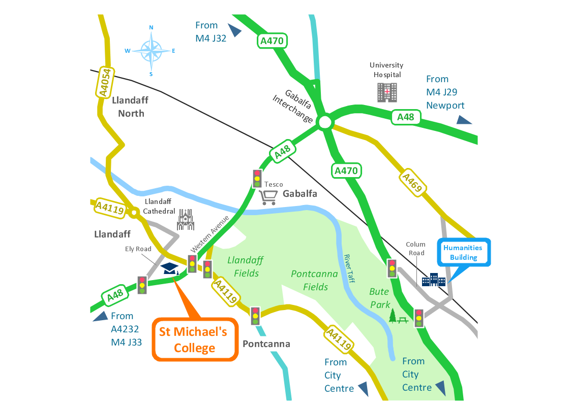
"Road maps come in many shapes, sizes and scales. Small, single-page maps may be used to give an overview of a region's major routes and features. ...
Highway maps generally give an overview of major routes within a medium to large region ranging from a few dozen to a few thousand miles or kilometers.
Street maps usually cover an area of a few miles or kilometers (at most) within a single city or extended metropolitan area. City maps are generally a specialized form of street map." [Road map. Wikipedia]
This 3D pictorial road map example was created using the ConceptDraw PRO diagramming and vector drawing software extended with the Directional Maps solution from the Maps area of ConceptDraw Solution Park.
3D Directional map

How to draw Metro Map style infographics? (Los Angeles)

This is a one-click tool to add stations to the map. It lets you control the direction in which you create new stations, change lengths, and add text labels and icons. It contains Lines, Stations, and Landmarks objects.
How to draw Metro Map style infographics? Moscow, New York, Los Angeles, London

Rail transport - Design elements
Use it to draw illustrations of trains and transportation of passengers and goods by railroads.
Nature Drawings - How to Draw
Road Transport - Design Elements
- Directional Maps | 3d Road Map Clip Art
- Navigation Road Map Clipart
- Road Map Clipart Png
- Road Map
- 3D pictorial street map | Road Transport - Design Elements | Road ...
- Road Maps
- Directional Maps | Presentation Clipart | Map Directions Clipart
- 3D pictorial street map | Road signs - Vector stencils library ...
- A Png Road Map Directional Sign
- Road Maps Location
- ERD | Entity Relationship Diagrams, ERD Software for Mac and Win
- Flowchart | Basic Flowchart Symbols and Meaning
- Flowchart | Flowchart Design - Symbols, Shapes, Stencils and Icons
- Flowchart | Flow Chart Symbols
- Electrical | Electrical Drawing - Wiring and Circuits Schematics
- Flowchart | Common Flowchart Symbols
- Flowchart | Common Flowchart Symbols