Subway Train Map
 Metro Map
Metro Map solution extends ConceptDraw DIAGRAM software with templates, samples and library of vector stencils for drawing the metro maps, route maps, bus and other transport schemes, or design tube-style infographics.
Metro Maps

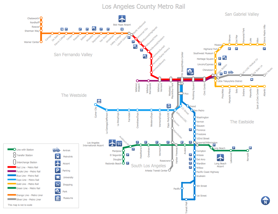
How to draw Metro Map style infographics? (Los Angeles)

This is a one-click tool to add stations to the map. It lets you control the direction in which you create new stations, change lengths, and add text labels and icons. It contains Lines, Stations, and Landmarks objects.
How to draw Metro Map style infographics? (New York)

New York Subway has a long history starting on October 27, 1904. Since the opening many agencies have provided schemes of the subway system. At present time are 34 lines in use. This page present New York City subway map construct with Metro Map Solution in Conceptdraw DIAGRAM software. This is a one-click tool to add stations to the map. It lets you control the direction in which you create new stations, change lengths, and add text labels and icons. It contains Lines, Stations, and Landmarks objects
Brilliant Examples of Infographics Map, Transport, Road
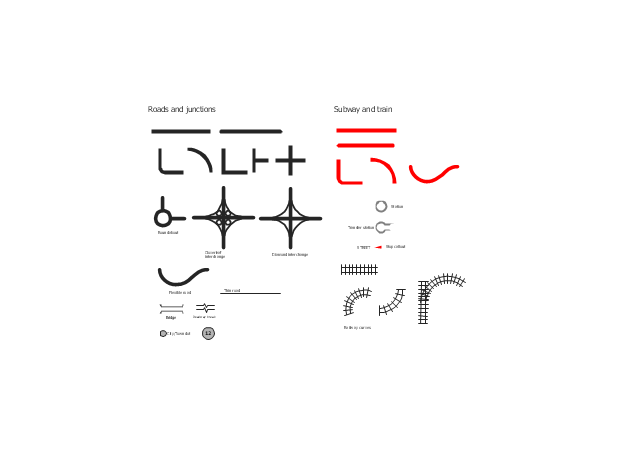
The vector stencils library "Roads and junctions" contains 38 symbols for creating the road and route maps, transit and directional maps, street and locator maps using the ConceptDraw PRO diagramming and vector drawing software.
The vector stencils library "Subway and train" contains 22 shapes for creating the transit maps of tube (metro) and railway.
"Road maps are perhaps the most widely used maps today, and form a subset of navigational maps, which also include aeronautical and nautical charts, railroad network maps, and hiking and bicycling maps." [Map. Wikipedia]
The example "Design elements - Roads and junctions, subway and train" is included in the Directional Maps solution from the Maps area of ConceptDraw Solution Park.
Road map stencils
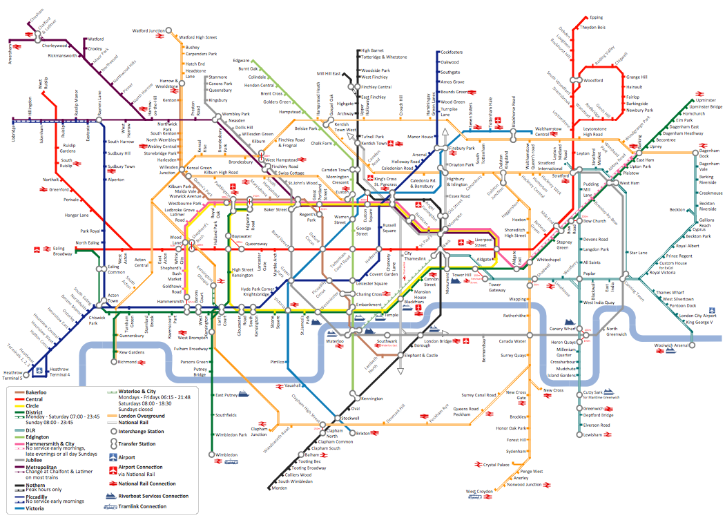
How to draw Metro Map style infographics? (London)
Transportation Infographics
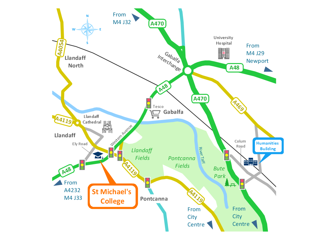
Use this template for creating the directional maps, location plans, site schemes, transit schemes, road maps, route maps.
"A road map or route map is a map that primarily displays roads and transport links rather than natural geographical information. It is a type of navigational map that commonly includes political boundaries and labels, making it also a type of political map. In addition to roads and boundaries, road maps often include points of interest, such as prominent businesses or buildings, tourism sites, parks and recreational facilities, hotels and restaurants, as well as airports and train stations. A road map may also document non-automotive transit routes, although often these are found only on transit maps." [Road map. Wikipedia]
This template for the ConceptDraw PRO diagramming and vector drawing software is included in the Directional Maps solution from the Maps area of ConceptDraw Solution Park.
Directional map template

- Railway Map Creator
- Map Infographic Creator | Subway Map Creator Software Free
- Subway Train Map | How to draw Metro Map style infographics ...
- Powerpoint Graphic Railway Map
- Train Map Creator
- Metro Train Map
- Subway Map Creator Mac
- Subway Train Map | Metro Train Map | Rail transport - Design ...
- Rail transport - Vector stencils library | Subway Train Map | Design ...
- Transit map template | Transport map - Template | Spatial ...
- ERD | Entity Relationship Diagrams, ERD Software for Mac and Win
- Flowchart | Basic Flowchart Symbols and Meaning
- Flowchart | Flowchart Design - Symbols, Shapes, Stencils and Icons
- Flowchart | Flow Chart Symbols
- Electrical | Electrical Drawing - Wiring and Circuits Schematics
- Flowchart | Common Flowchart Symbols
- Flowchart | Common Flowchart Symbols