Alphabetical list of subregions in the United Nations geoscheme for Europe.
Eastern Europe: Belarus, Bulgaria, Czech Republic, Hungary, Moldova, Poland, Romania, Russia, Slovakia, Ukraine.
Northern Europe: Åland Islands, Denmark, Estonia, Faroe Islands, Finland, Guernsey, Iceland, Ireland, Isle of Man, Jersey, Latvia, Lithuania, Norway, Svalbard and Jan Mayen, Sweden, United Kingdom.
Southern Europe: Albania, Andorra, Bosnia and Herzegovina, Croatia, Gibraltar, Greece, Italy, Malta, Montenegro, Portugal, Macedonia, San Marino, Serbia, Slovenia, Spain, Vatican City.
Western Europe: Austria, Belgium, France, Germany, Liechtenstein, Luxembourg, Monaco, Netherlands, Switzerland.
" [United Nations geoscheme for Europe. Wikipedia]
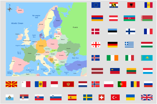
This Europe political map example illustrated with European countries flags clipart was drawn using ConceptDraw PRO diagramming and vector drawing software extended with design elements libraries Europe and Europe flags.
These vector stencils libraries are included in the Continent Maps solution from Maps area of ConceptDraw Solution Park.
www.conceptdraw.com/ solution-park/ maps-continent
Eastern Europe: Belarus, Bulgaria, Czech Republic, Hungary, Moldova, Poland, Romania, Russia, Slovakia, Ukraine.
Northern Europe: Åland Islands, Denmark, Estonia, Faroe Islands, Finland, Guernsey, Iceland, Ireland, Isle of Man, Jersey, Latvia, Lithuania, Norway, Svalbard and Jan Mayen, Sweden, United Kingdom.
Southern Europe: Albania, Andorra, Bosnia and Herzegovina, Croatia, Gibraltar, Greece, Italy, Malta, Montenegro, Portugal, Macedonia, San Marino, Serbia, Slovenia, Spain, Vatican City.
Western Europe: Austria, Belgium, France, Germany, Liechtenstein, Luxembourg, Monaco, Netherlands, Switzerland.
" [United Nations geoscheme for Europe. Wikipedia]
This Europe political map example illustrated with European countries flags clipart was drawn using ConceptDraw PRO diagramming and vector drawing software extended with design elements libraries Europe and Europe flags.
These vector stencils libraries are included in the Continent Maps solution from Maps area of ConceptDraw Solution Park.
www.conceptdraw.com/ solution-park/ maps-continent
Geo Map - Europe - Germany

- Political map of Europe
- Political map of Europe | Tools to Create Your Own Infographics ...
- Design elements - Europe | Spatial infographics Design Elements ...
- Europe map template | Map Infographic Creator | European ...
- Infographic software: the sample of New York City Subway map ...
- Continent Maps | Spatial infographics Design Elements: Location ...
- Continent Maps | Spatial infographics Design Elements: Location ...
- Continent Maps | Picture graph - Population growth by continent ...
- ERD | Entity Relationship Diagrams, ERD Software for Mac and Win
- Flowchart | Basic Flowchart Symbols and Meaning
- Flowchart | Flowchart Design - Symbols, Shapes, Stencils and Icons
- Flowchart | Flow Chart Symbols
- Electrical | Electrical Drawing - Wiring and Circuits Schematics
- Flowchart | Common Flowchart Symbols
- Flowchart | Common Flowchart Symbols