How to draw Metro Map style infographics? (London)
Metro Map

The Metro Map Solution from the Maps Area uses two ConceptDraw techniques: Replicating Objects and Switching Objects. And the result is a vector graphic document.
How to draw Metro Map style infographics? Moscow, New York, Los Angeles, London

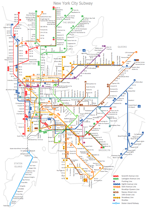
MTA Subway Map
 Metro Map
Metro Map solution extends ConceptDraw DIAGRAM software with templates, samples and library of vector stencils for drawing the metro maps, route maps, bus and other transport schemes, or design tube-style infographics.
 Metro Map
Metro Map solution extends ConceptDraw DIAGRAM software with templates, samples and library of vector stencils for drawing the metro maps, route maps, bus and other transport schemes, or design tube-style infographics.
Metro Path Map

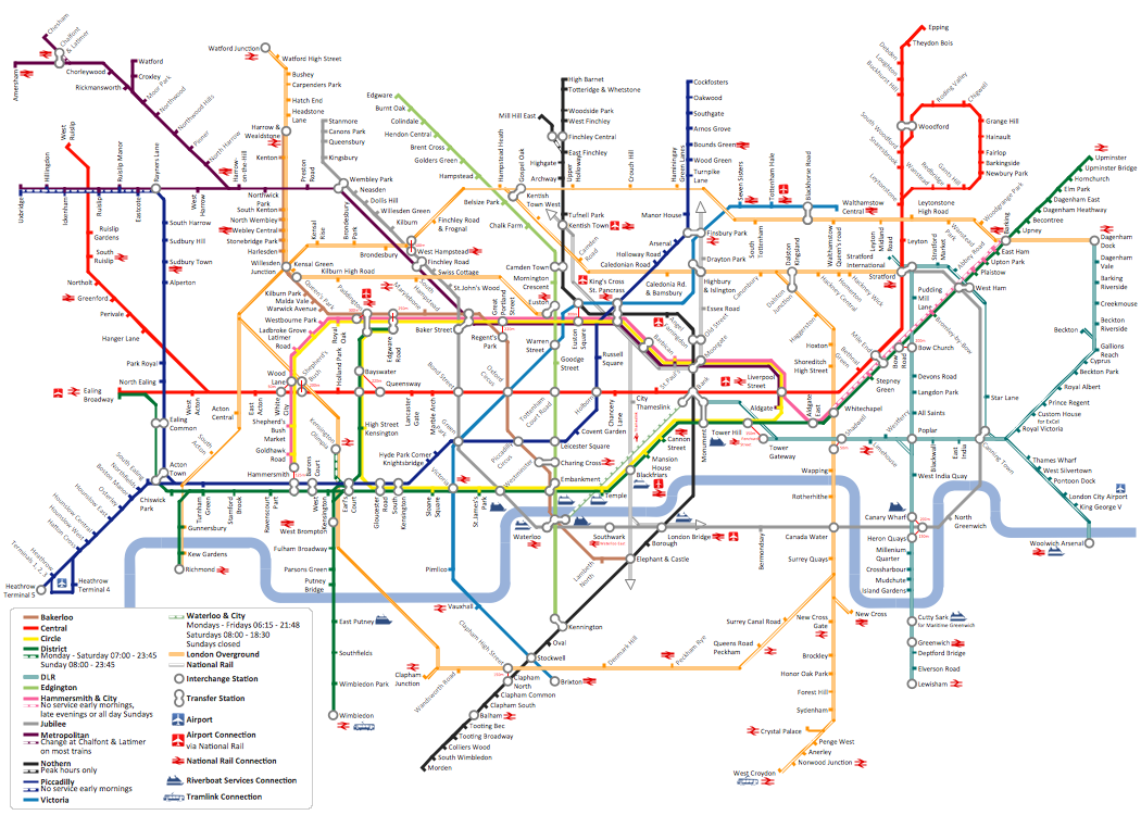
This spatial infographic example was created on the base of the tube map from the Transport for London website.
[tfl.gov.uk/ assets/ images/ general/ 24746-nle-gallery-tube-map.jpg]
"The Tube map is a schematic transit map of the lines and stations of London's public rapid transit railway systems, namely the London Underground (commonly known as the Tube, hence the name), Docklands Light Railway, London Overground and Emirates Air Line, as well as being incorporated into Greater London connections maps.
As a schematic diagram, it shows not necessarily the geographic but rather the relative positions of stations along the lines, stations' connective relations with each other and fare zones. The basic design concepts have been widely adopted for other network maps around the world, especially that of mapping topologically rather than geographically." [Tube map. Wikipedia]
The spatial infographics example "Metro map - Northern line extension to Battersea via Nine Elms" was created using the ConceptDraw PRO diagramming and vector drawing software extended with the Spatial Infographics solution from the area "What is Infographics" of ConceptDraw Solution Park.
Tube map

 UK Map
The Map of UK solution contains collection of professionally designed samples and scalable vector stencil graphics maps, representing the United Kingdom counties, regions and cities. Use the Map of UK solution from ConceptDraw Solution Park as the base fo
United Kingdom Cities
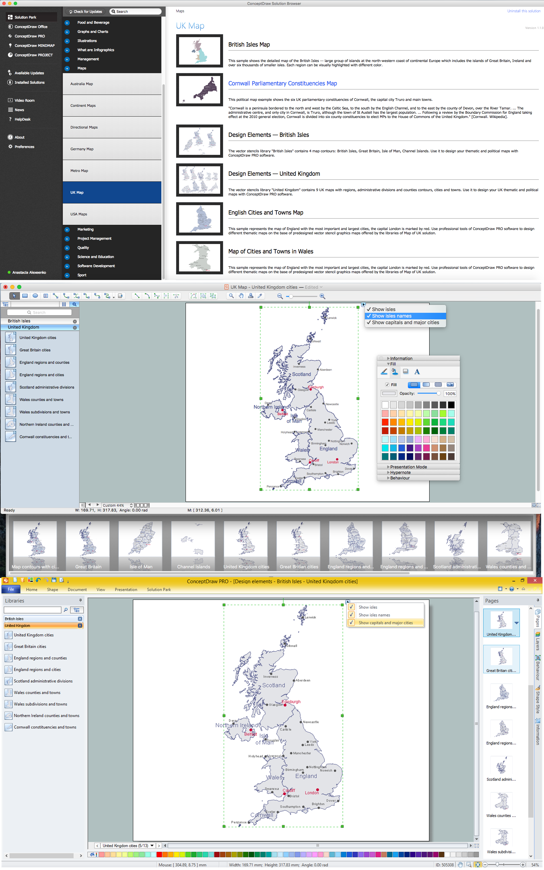
How to design the Map of UK fast and easy? It is incredibly convenient to use special software. ConceptDraw DIAGRAM diagramming and vector drawing software offers the Map of UK Solution from the Maps Area of ConceptDraw Solution Park specially developed to make easier drawing the maps of UK counties, various UK related thematic maps and cartograms on their base.
 Spatial Infographics
Spatial infographics solution extends ConceptDraw DIAGRAM software with infographic samples, map templates and vector stencils libraries with design elements for drawing spatial information graphics.
Examples of Flowcharts, Org Charts and More
 Divided Bar Diagrams
The Divided Bar Diagrams Solution extends the capabilities of ConceptDraw DIAGRAM with templates, samples, and a library of vector stencils for drawing high impact and professional Divided Bar Diagrams and Graphs, Bar Diagram Math, and Stacked Graph.
Business Diagram Software

- London Tube Map Vector File
- Vector Map of Germany | MTA Subway Map | Value Stream Mapping ...
- The 100th Tour de France - Route map | ELR route map | ARL route ...
- How to draw Metro Map style infographics? ( London ) | Value Stream ...
- How to draw Metro Map style infographics? ( London ) | How to draw ...
- Metro Map | How to draw Metro Map style infographics? Moscow ...
- Metro Map | How to draw Metro Map style infographics? ( London ...
- How to draw Metro Map style infographics? ( London ) | How to draw ...
- Catabolism schematic - Biochemical diagram | Metro map - Northern ...
- MTA Subway Map
- How to draw Metro Map style infographics? ( London ) | Infographic ...
- How to draw Metro Map style infographics? Moscow, New York, Los ...
- How to draw Metro Map style infographics? ( London ) | Metro Map ...
- Metro Map Vector Free
- Spatial Infographics | How to draw Metro Map style infographics ...
- Vector Graphics
- Metro Map | ELR route map | 2D Directional map - Template | Route ...
- How to draw Metro Map style infographics? ( London ) | How to draw ...
- How to draw Metro Map style infographics? ( London ) | Detail ...
- How to draw Metro Map style infographics? Moscow, New York, Los ...
- ERD | Entity Relationship Diagrams, ERD Software for Mac and Win
- Flowchart | Basic Flowchart Symbols and Meaning
- Flowchart | Flowchart Design - Symbols, Shapes, Stencils and Icons
- Flowchart | Flow Chart Symbols
- Electrical | Electrical Drawing - Wiring and Circuits Schematics
- Flowchart | Common Flowchart Symbols
- Flowchart | Common Flowchart Symbols