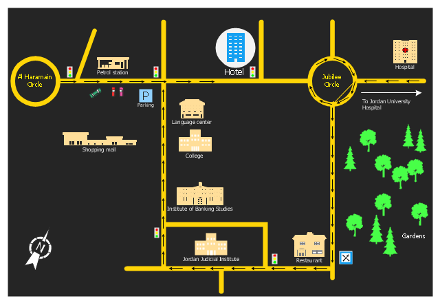
"A locator map, sometimes referred to simply as a locator, is typically a simple map used in cartography to show the location of a particular geographic area within its larger and presumably more familiar context. Depending on the needs of the cartographer, this type of map can be used on its own or as an inset or addition to a larger map. ...
Direct marketing.
The widespread distribution of sophisticated Geographic Information System (GIS) mapping techniques has allowed the development of large-scale customized locator maps that can be tailored to individual consumers in direct marketing campaigns. This sophistication allows a variety of customized locator maps to be produced in a relatively short period of time. Major types of direct marketing locator maps are:
Single Location: A single business location is shown with major street and road connections. While this type of map can be efficiently constructed using GIS with existing street databases and customized map templates, special software is not required because the map does not change for each direct mailing." [Locator map. Wikipedia]
This example was created using the ConceptDraw PRO diagramming and vector drawing software extended with the Directional Maps solution from the Maps area of ConceptDraw Solution Park.
Hotel location map
The vector stencils library "Road signs" contains 58 symbols of road signs for labeling the road and route maps, directional and transit maps, street and locator maps.
"Traffic signs or road signs are signs erected at the side of or above roads to give instructions or provide information to road users.
... many countries have adopted pictorial signs or otherwise simplified and standardized their signs to overcome language barriers, and enhance traffic safety. Such pictorial signs use symbols (often silhouettes) in place of words and are usually based on international protocols. Such signs were first developed in Europe, and have been adopted by most countries to varying degrees." [Traffic sign. Wikipedia]
The pictograms example "Road signs - Vector stencils library" was created using the ConceptDraw PRO diagramming and vector drawing software extended with the Directional Maps solution from the Maps area of ConceptDraw Solution Park.
www.conceptdraw.com/ solution-park/ maps-directional
Danger place

Intersection

Intersection 2

Bend

Double bend

Two-way traffic

Mobile bridge

Light signal

Pedestrian crossing

Road work

Back-up

Give way

Crossing

Stop

Roundabout

Pass this side

Direction to be followed

One-way street

Cycle track

No entry

No entry both directions

No power vehicles

No U-turns

No passing without stopping

No standing and parking

No parking

Speed limit

Height limit

Width limit

Weight limit

Priority over oncoming traffic

Streetcar or regular buses

Taxi status

Beginning that speed 30-Zone

End that speed 30-Zone

Pedestrian crossing 2

Police

Hotel

Breakdown service

Restaurant

P + R

Restroom

Fuel

Telephone

Recommended speed

Nodal point of a motorwa

Parking

Dead end

Motorway

End motorway

Populated zone

End populated zone

Parking with clock

Number sign (motorway)
-road-signs---vector-stencils-library.png--diagram-flowchart-example.png)
Exit

Direction to place

Board of announcement of exit

Number sign (federal highway)
-road-signs---vector-stencils-library.png--diagram-flowchart-example.png)
 Directional Maps
Directional Maps solution extends ConceptDraw DIAGRAM software with templates, samples and libraries of vector stencils for drawing the directional, location, site, transit, road and route maps, plans and schemes.
UML Collaboration Diagram. Design Elements
ConceptDraw has 393 vector stencils in the 13 libraries that helps you to start using software for designing your own UML Diagrams. You can use the appropriate stencils of UML notation from UML Collaboration library with 36 objects
- Hotel Locators
- Hotel locator map
- Locator map - Template | Hotel locator map | Maps | Locator Map
- Hotel locator map | Rolla USGS Center locator map | Locator map of ...
- Hotel locator map | Design elements - 3D directional maps | Design ...
- Simple Maps Of Hotel
- Landmarks - Vector stencils library | Hotel locator map | Landmarks ...
- Hotel Emergency Exit Map
- 3D pictorial street map | Design elements - 3D directional maps ...
- Floor Plans | Simple Hotel Layout
- ERD | Entity Relationship Diagrams, ERD Software for Mac and Win
- Flowchart | Basic Flowchart Symbols and Meaning
- Flowchart | Flowchart Design - Symbols, Shapes, Stencils and Icons
- Flowchart | Flow Chart Symbols
- Electrical | Electrical Drawing - Wiring and Circuits Schematics
- Flowchart | Common Flowchart Symbols
- Flowchart | Common Flowchart Symbols