The vector stencils library "IVR Internet" contains 36 interactive voice response (IVR) Internet and web icons.
Use it to design your IVR diagrams with ConceptDraw PRO diagramming and vector drawing software.
The vector stencils library "IVR Internet" is included in the Interactive Voice Response Diagrams solution from the Computer and Networks area of ConceptDraw Solution Park.
Use it to design your IVR diagrams with ConceptDraw PRO diagramming and vector drawing software.
The vector stencils library "IVR Internet" is included in the Interactive Voice Response Diagrams solution from the Computer and Networks area of ConceptDraw Solution Park.
Cloud

Cloud connection

Cloud data exchange

Cloud download

Cloud network

Cloud synchronization

Cloud upload

Email contacts

Flag

Geolocation

GIS

Global network

Hyperlink

Internet

Message

Messenger

Mobile cloud computing

News

Photos

Social contacts

Social network

Synchronization

User profile

Video

Video player

WWW

Web

Webmail

Web access

Web browser

Web help

Webpage

Web page

Web security

Web traffic

Wireless Web access

Using Fishbone Diagrams for Problem Solving

Using Fishbone Diagrams for Problem Solving is a productive and illustrative tool to identify the most important factors causing the trouble. ConceptDraw PRO extended with Fishbone Diagrams solution from the Management area of ConceptDraw Solution Park is a powerful tool for problem solving with Fishbone Ishikawa diagram graphic method.
The vector stencils library "IVR Internet" contains 36 interactive voice response (IVR) Internet and web icons.
Use it to design your IVR diagrams with ConceptDraw PRO diagramming and vector drawing software.
The vector stencils library "IVR Internet" is included in the Interactive Voice Response Diagrams solution from the Computer and Networks area of ConceptDraw Solution Park.
Use it to design your IVR diagrams with ConceptDraw PRO diagramming and vector drawing software.
The vector stencils library "IVR Internet" is included in the Interactive Voice Response Diagrams solution from the Computer and Networks area of ConceptDraw Solution Park.
Cloud
Cloud connection
Cloud data exchange
Cloud download
Cloud network
Cloud synchronization
Cloud upload
Email contacts
Flag
Geolocation
GIS
Global network
Hyperlink
Internet
Message
Messenger
Mobile cloud computing
News
Photos
Social contacts
Social network
Synchronization
User profile
Video
Video player
WWW
Web
Webmail
Web access
Web browser
Web help
Webpage
Web page
Web security
Web traffic
Wireless Web access
"A locator map, sometimes referred to simply as a locator, is typically a simple map used in cartography to show the location of a particular geographic area within its larger and presumably more familiar context. Depending on the needs of the cartographer, this type of map can be used on its own or as an inset or addition to a larger map. ...
Direct marketing.
The widespread distribution of sophisticated Geographic Information System (GIS) mapping techniques has allowed the development of large-scale customized locator maps that can be tailored to individual consumers in direct marketing campaigns. This sophistication allows a variety of customized locator maps to be produced in a relatively short period of time. Major types of direct marketing locator maps are:
Single Location: A single business location is shown with major street and road connections. While this type of map can be efficiently constructed using GIS with existing street databases and customized map templates, special software is not required because the map does not change for each direct mailing." [Locator map. Wikipedia]
This example was created using the ConceptDraw PRO diagramming and vector drawing software extended with the Directional Maps solution from the Maps area of ConceptDraw Solution Park.
Hotel location map
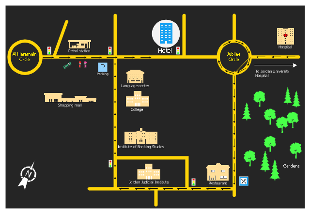
The 3D pictorial street maps are used as road maps, route maps, locator maps, transit maps, directional maps, tourist maps with points of interest (POI).
"A point of interest, or POI, is a specific point location that someone may find useful or interesting. ...
Most consumers use the term when referring to hotels, campsites, fuel stations or any other categories used in modern (automotive) navigation systems. ...
The term is widely used in cartography, especially in electronic variants including GIS, and GPS navigation software. In this context the synonym waypoint is common.
A GPS point of interest specifies, at minimum, the latitude and longitude of the POI, assuming a certain map datum. A name or description for the POI is usually included, and other information such as altitude or a telephone number may also be attached. GPS applications typically use icons to represent different categories of POI on a map graphically." [Point of interest. Wikipedia]
The example "3D pictorial street map" was created using the ConceptDraw PRO diagramming and vector drawing software extended with the Directional Maps solution from the Maps area of ConceptDraw Solution Park.
3D pictorial street map

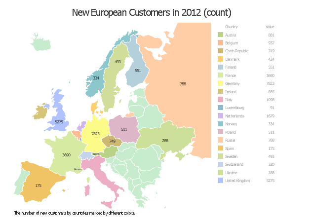
"Location Intelligence is the capacity to organize and understand complex phenomena through the use of geographic relationships inherent in all information. By combining geographic- and location-related data with other business data, organizations can gain critical insights, make better decisions and optimize important processes and applications. Location Intelligence offers organizations opportunities to streamline their business processes and customer relationships to improve performance and results.
Location Intelligence tools leverage a variety of data sources including aerial maps, geographic information systems (GIS), consumer demographics as well as a user’s own customer records. ...
Location Intelligence is also used to describe the integration of a geographical component into Business Intelligence processes and tools, often incorporating Spatial Database and spatial OLAP tools." [Location intelligence. Wikipedia]
The location intelligence dashboard example "New European Customers" was created using the ConceptDraw PRO diagramming and vector drawing software extended with the Spatial Dashboard solution from the area "What is a Dashboard" of ConceptDraw Solution Park.
Location intelligence dashboard
- Gis Clipart Png Files
- Gis Png
- Basic Flowchart Symbols and Meaning | Work Flow Diagram Of Gis
- Webpage Icon Png
- Geolocation Icon Png
- Png Lights
- Png Web
- Buy Internet Vector Png
- Supermarket 3d City Png
- Contact Mobile Png
- ERD | Entity Relationship Diagrams, ERD Software for Mac and Win
- Flowchart | Basic Flowchart Symbols and Meaning
- Flowchart | Flowchart Design - Symbols, Shapes, Stencils and Icons
- Flowchart | Flow Chart Symbols
- Electrical | Electrical Drawing - Wiring and Circuits Schematics
- Flowchart | Common Flowchart Symbols
- Flowchart | Common Flowchart Symbols