 Germany Map
The Germany Map solution contains collection of samples, templates and scalable vector stencil graphic maps, representing map of Germany and all 16 states of Germany. Use the Germany Map solution from ConceptDraw Solution Park as the base for various them
Map of Germany — Saarland State

Despite the fact that the maps surround us everywhere in our life, usually the process of their drawing is sufficienly complex and labor-intensive. But now, thanks to the ConceptDraw PRO diagramming and vector drawing software extended with Germany Map Solution from the Maps Area of ConceptDraw Solution Park, we have the possibility to make easier this process. Design fast and easy your own pictorial maps of Germany, map of Germany with cities, and thematic Germany maps in ConceptDraw PRO!
Map of Germany — Hesse State

Despite the fact that the maps surround us everywhere in our life, usually the process of their drawing is sufficienly complex and labor-intensive. But now, thanks to the ConceptDraw PRO diagramming and vector drawing software extended with Germany Map Solution from the Maps Area of ConceptDraw Solution Park, we have the possibility to make easier this process. Design fast and easy your own pictorial maps of Germany, map of Germany with cities, and thematic Germany maps in ConceptDraw PRO!
Map of Germany — Rhineland-Palatinate State

Despite the fact that the maps surround us everywhere in our life, usually the process of their drawing is sufficienly complex and labor-intensive. But now, thanks to the ConceptDraw PRO diagramming and vector drawing software extended with Germany Map Solution from the Maps Area of ConceptDraw Solution Park, we have the possibility to make easier this process. Design fast and easy your own pictorial maps of Germany, map of Germany with cities, and thematic Germany maps in ConceptDraw PRO!
Map of Germany — Lower Saxony State

Despite the fact that the maps surround us everywhere in our life, usually the process of their drawing is sufficienly complex and labor-intensive. But now, thanks to the ConceptDraw PRO diagramming and vector drawing software extended with Germany Map Solution from the Maps Area of ConceptDraw Solution Park, we have the possibility to make easier this process. Design fast and easy your own pictorial maps of Germany, map of Germany with cities, and thematic Germany maps in ConceptDraw PRO!
Map of Germany — Hamburg

Despite the fact that the maps surround us everywhere in our life, usually the process of their drawing is sufficienly complex and labor-intensive. But now, thanks to the ConceptDraw PRO diagramming and vector drawing software extended with Germany Map Solution from the Maps Area of ConceptDraw Solution Park, we have the possibility to make easier this process. Design fast and easy your own pictorial maps of Germany, map of Germany with cities, and thematic Germany maps in ConceptDraw PRO!
Map of Germany — Schleswig-Holstein State

Despite the fact that the maps surround us everywhere in our life, usually the process of their drawing is sufficienly complex and labor-intensive. But now, thanks to the ConceptDraw PRO diagramming and vector drawing software extended with Germany Map Solution from the Maps Area of ConceptDraw Solution Park, we have the possibility to make easier this process. Design fast and easy your own pictorial maps of Germany, map of Germany with cities, and thematic Germany maps in ConceptDraw PRO!
Map of Germany — Bremen

Despite the fact that the maps surround us everywhere in our life, usually the process of their drawing is sufficienly complex and labor-intensive. But now, thanks to the ConceptDraw PRO diagramming and vector drawing software extended with Germany Map Solution from the Maps Area of ConceptDraw Solution Park, we have the possibility to make easier this process. Design fast and easy your own pictorial maps of Germany, map of Germany with cities, and thematic Germany maps in ConceptDraw PRO!
This Germany political map example was created on the base of Wikimedia Commons file: Deutschland politisch bunt.png. [commons.wikimedia.org/ wiki/ File:Deutschland_ politisch_ bunt.png]
This file is licensed under the Creative Commons Attribution-Share Alike 2.5 Generic license. [creativecommons.org/ licenses/ by-sa/ 2.5/ deed.en]
"Germany (German: Deutschland), officially the Federal Republic of Germany (German: Bundesrepublik Deutschland), is a federal parliamentary republic in West-Central Europe. It includes 16 constituent states and covers an area of 357,021 square kilometres (137,847 sq mi) with a largely temperate seasonal climate. Its capital and largest city is Berlin. With about 81.5 million inhabitants, Germany is the most populous member state in the European Union. After the United States, it is the second most popular migration destination in the world." [Germany. Wikipedia]
The example "Political map of Germany" was designed using the ConceptDraw PRO software extended with the Map of Germany solution from the Maps area of ConceptDraw Solution Park.
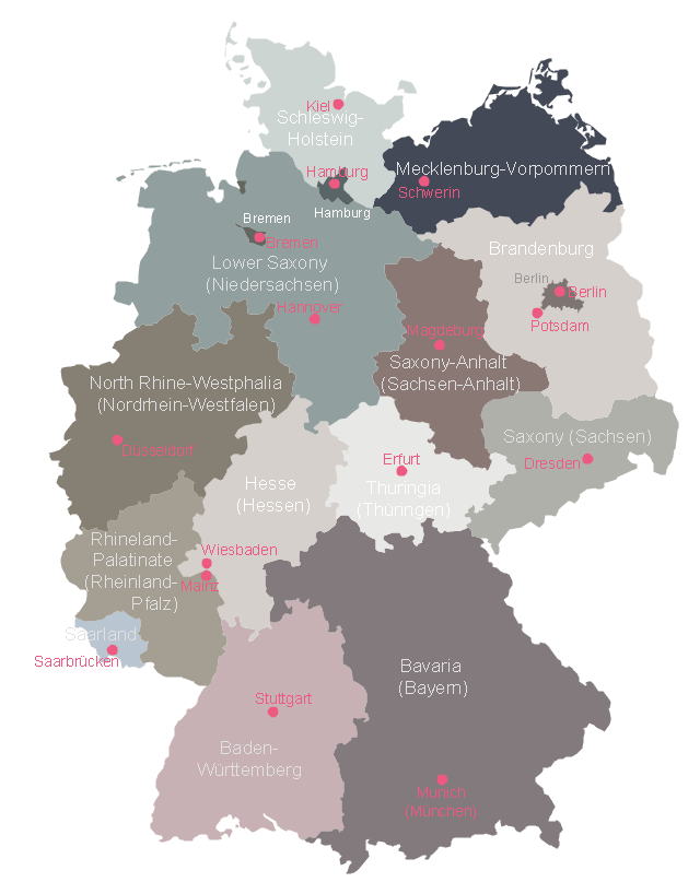
States and cities map example
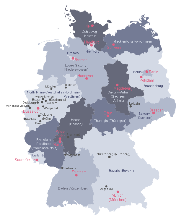
This Germany political map example was created on the base of Wikimedia Commons file: Map Germany Länder-en.svg. [commons.wikimedia.org/ wiki/ File:Map_ Germany_ Länder-en.svg]
This file is licensed under the Creative Commons Attribution-Share Alike 3.0 Unported license. [creativecommons.org/ licenses/ by-sa/ 3.0/ deed.en]
"Germany is a federal republic consisting of sixteen federal states (German: Bundesland, or Land). Since today's Germany was formed from an earlier collection of several states, it has a federal constitution, and the constituent states retain a measure of sovereignty. With an emphasis on geographical conditions, Berlin and Hamburg are frequently called Stadtstaaten (city-states), as is the Free Hanseatic City of Bremen, which in fact includes the cities of Bremen and Bremerhaven. The remaining 13 states are called Flächenländer (literally: area states)." [States of Germany. Wikipedia]
The political map example "Map of German states" was designed using the ConceptDraw PRO software extended with the Map of Germany solution from the Maps area of ConceptDraw Solution Park.
Germany federal states map example
Maps of Germany With Cities

Maps of Germany

Geo Map - Europe - Germany

Map of Germany — Brandenburg State

Despite the fact that the maps surround us everywhere in our life, usually the process of their drawing is sufficienly complex and labor-intensive. But now, thanks to the ConceptDraw PRO diagramming and vector drawing software extended with Germany Map Solution from the Maps Area of ConceptDraw Solution Park, we have the possibility to make easier this process. Design fast and easy your own pictorial maps of Germany, map of Germany with cities, and thematic Germany maps in ConceptDraw PRO!
Infographic software: the sample of New York City Subway map

- German City Map
- Maps of Germany With Cities | Infographic software: the sample of ...
- Maps of Germany With Cities | Map of Germany — Saarland State ...
- Map Of East Germany With Cities
- Map Of Major German Cities
- Maps of Germany With Cities | Maps of Germany | Map of Germany ...
- Major Cities In Germany Map
- Infographic software: the sample of New York City Subway map ...
- Map of Germany — Saarland State | Germany Map | Map of ...
- European City Maps
- Maps of Germany | How to Create a Map of Germany Using ...
- Germany Map | Map of Germany — Saarland State | Map of ...
- Germany Maps Design Vector Samples
- Map of Germany — Hesse State | How to Create a Map of Germany ...
- Geo Map - Europe - Greece | Map of Germany — Rhineland ...
- Germany Map | Geo Map - Europe - Germany | How to Create a Map ...
- Vector Map of Germany | Maps of Germany With Cities | Map of ...
- Stars and planets - Vector stencils library | Chart Examples | Map of ...
- Map of Germany — Schleswig-Holstein State | Germany Map | Map ...
- Map of Germany — Bremen | Geo Map - Europe - Germany ...
- ERD | Entity Relationship Diagrams, ERD Software for Mac and Win
- Flowchart | Basic Flowchart Symbols and Meaning
- Flowchart | Flowchart Design - Symbols, Shapes, Stencils and Icons
- Flowchart | Flow Chart Symbols
- Electrical | Electrical Drawing - Wiring and Circuits Schematics
- Flowchart | Common Flowchart Symbols
- Flowchart | Common Flowchart Symbols