Superb Examples of Infographic Maps

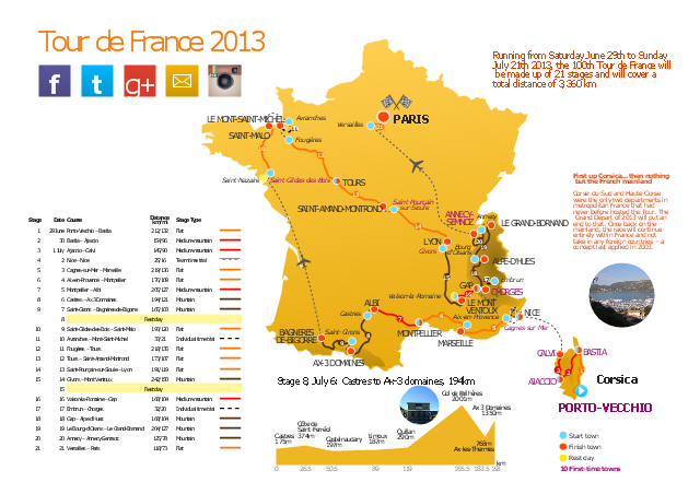
This route map example was redesigned from the Wikipedia file: Route of the 2013 Tour de France.png.
[en.wikipedia.org/ wiki/ File:Route_ of_ the_ 2013_ Tour_ de_ France.png]
This file is licensed under the Creative Commons Attribution-Share Alike 3.0 Unported license. [creativecommons.org/ licenses/ by-sa/ 3.0/ deed.en]
"A road map or route map is a map that primarily displays roads and transport links rather than natural geographical information. It is a type of navigational map that commonly includes political boundaries and labels, making it also a type of political map. In addition to roads and boundaries, road maps often include points of interest, such as prominent businesses or buildings, tourism sites, parks and recreational facilities, hotels and restaurants, as well as airports and train stations. A road map may also document non-automotive transit routes, although often these are found only on transit maps." [Road map. Wikipedia]
The spatial infographics example "The 100th Tour de France - Route map" was created using the ConceptDraw PRO diagramming and vector drawing software extended with the Spatial Infographics solution from the area "What is Infographics" of ConceptDraw Solution Park.
Route map
Excellent Examples of Infographic Maps

How to Create a Powerful Infographic When You do not Have a Designer

Travel Infographics

The vector stencils library "Recreation signs" contains 28 pictogram symbols of recreation signs for labeling street and directional maps, locator and tourist maps, road and route maps.
"A tourist sign, often referred to as a brown sign, is a traffic sign whose purpose is to direct visitors to tourist destinations, such as historic buildings, tourist regions, caravan or camp sites, picnic areas, sporting facilities and cultural places such as museums. By international convention, brown signs with white lettering and white pictograms are often used for this purpose. ...
Basically these tourist signs have 3 main applications:
(1) Information signs and signposts that point to important tourist destinations or places of interest in the local area, for example within a village or town.
(2) Standard signs that are used to mark routes with special themes, i.e. so-called tourist or holiday routes.
(3) Tourist signs that herald the presence of nearby landscapes, towns and regions, usually on long distance routes such as motorways. They are not used as direction signs." [Tourist sign. Wikipedia]
The pictograms example "Recreation signs - Vector stencils library" was created using the ConceptDraw PRO diagramming and vector drawing software extended with the Directional Maps solution from the Maps area of ConceptDraw Solution Park.
www.conceptdraw.com/ solution-park/ maps-directional
Parking

Amphitheater

Campfire

Cross-country skiing

Volleyball

Supplies/store

Climbing

Handball/racquetball

Boat launch

Downhill skiing

Shower

Fishing

Golf

Skating

Canoe access

Horseback riding

Tennis

Kayaking

Marina

Hiking

Snowboarding

Scuba diving

Swimming

Snowmobile

Restroom

Potable water

Campground

RV

 Spatial Infographics
Spatial infographics solution extends ConceptDraw PRO software with infographic samples, map templates and vector stencils libraries with design elements for drawing spatial information graphics.
Process Flowchart


Sign Making Software

Sign making software is very useful tool for professional sign-making business. Use ConceptDraw PRO and make sure that now sign making is easier and timesaving than ever!
Design Pictorial Infographics. Design Infographics

Subway infographic design elements - software tools

The vector stencils library "Landmarks" contains 69 landmark symbols of buildings, waterways, scale and directional indicators for labeling transportation and directional maps, road and route maps, street and transit maps, locator and tourist maps.
The pictograms example "Landmarks - Vector stencils library" was created using the ConceptDraw PRO diagramming and vector drawing software extended with the Directional Maps solution from the Maps area of ConceptDraw Solution Park.
The pictograms example "Landmarks - Vector stencils library" was created using the ConceptDraw PRO diagramming and vector drawing software extended with the Directional Maps solution from the Maps area of ConceptDraw Solution Park.
Viewpoint

North arrow
North arrow
Building

Building

Town house

Suburban home

Skyscraper

Town hall

Public house

Petrol station

Gas station

Factory

School

Warehouse

Hospital

Fire station

Train station

Condos

Barn

Motel

Convenience store

Shopping centre

City

Church

Cathedral

National tail train station

Train railway

Bus stop

Tramlink

Marina / Ferry dock

Car ferry

Stop light

Airport

Airport

Underground / Subway / Metro

Taxi

Bicycle parking

Parking

Fuel / Gas / Petrol

Police

Hospital

Wheelchair access

First aid

Telephone

Post office

Landmarks and museums

University

Shopping

Refreshments / Public House

Restrooms / Toilets

Park

Zoo

Information center

Stadium 1

Stadium 2

Park

Tree

Fir-tree

Ocean

Lake

River

Angled river

Forked river

Curved river

Curved river

Flexible river

Bridge

Scale

Spatial infographics Design Elements: Location Map

Sample Pictorial Chart. Sample Infographics
")
Use Pictorial Infographics solution to draw your own design pictorial infographics documents quick and easy.
- 3D pictorial street map | The 100th Tour de France - Route map ...
- The 100th Tour de France - Route map | How to Create a Powerful ...
- ELR route map | The 100th Tour de France - Route map | ARL route ...
- Tourist Map Software
- Transport map - Vector stencils library | Travel and tourism ...
- Tourist Signs
- Brilliant Examples of Infographics Map , Transport, Road | Design ...
- The 100th Tour de France - Route map | Aerospace - Design ...
- Fire Exit Plan. Building Plan Examples | Emergency Plan | Transport ...
- Example Of Vicinity Map Of The House Wityh Landmark
- Example Of Railway Station Symbols In Maps
- 3D pictorial street map | Design elements - 3D directional maps ...
- 3D pictorial road map | 2D Directional map - Template | 3D pictorial ...
- The 100th Tour de France - Route map | Aircraft - Vector stencils ...
- Map symbols - Vector stencils library | Design elements - Location ...
- Road signs - Vector stencils library | Directions Map | Map Directions ...
- Road Map Suburbs And Houses Drawing
- 2D Directional map - Template | Maps Driving Directions ...
- Directional Maps | How to Create a Directional Map Using ...
- Hotel locator map | Rolla USGS Center locator map | Maps | Locator ...
- ERD | Entity Relationship Diagrams, ERD Software for Mac and Win
- Flowchart | Basic Flowchart Symbols and Meaning
- Flowchart | Flowchart Design - Symbols, Shapes, Stencils and Icons
- Flowchart | Flow Chart Symbols
- Electrical | Electrical Drawing - Wiring and Circuits Schematics
- Flowchart | Common Flowchart Symbols
- Flowchart | Common Flowchart Symbols