Spatial infographics Design Elements: Location Map
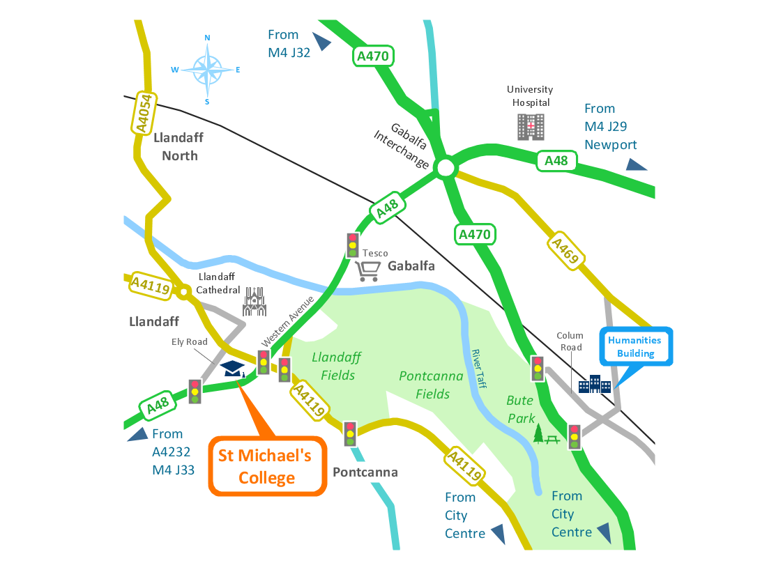
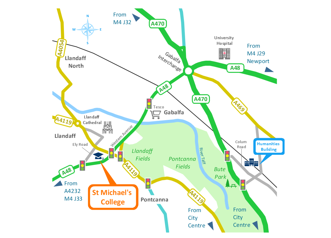
Infographic Design Elements for visually present various geographically distributed information.Brilliant Examples of Infographics Map, Transport, Road
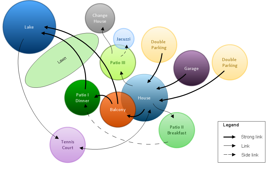
ConceptDraw DIAGRAM contains spatial infographics samples, map templates to be filled in, and libraries of vector stencils for main design elements of spatial infographics.Bubble diagrams in Landscape Design with ConceptDraw DIAGRAM
To define the links between the different areas of your own landscape design and see the project from aside, we recommend to draw landscape diagram called bubble one which is analogue of «mind maps» as it allows us to create approximate image of our future proper landscape view. Use special libraries (and we have plenty of them) with objects of landscape design to be able to create the detailed plan of your landscape which will be looking so smart and professionally good as the samples we provide were created by designers who know so much about making such kinds of design plans. Having ConceptDraw DIAGRAM as the assistant in your work, will ensure the success after using our product. Make the bubble diagrams as well as any other ones in minutes with ease having our application called ConceptDraw DIAGRAM and you will see how quick it will change your life simplifying lots of work.Spatial infographics Design Elements: Continental Map
ConceptDraw DIAGRAM is a software for making infographics illustrations. You can work with various components to build really impressive and easy-to-understand infographics design.Using Remote Networking Diagrams
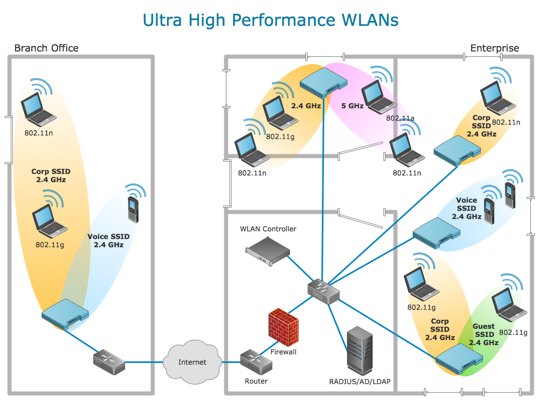
Remote Networking - We explain the method most people use to connect to the Internet.
Spatial infographics Design Elements: Transport Map
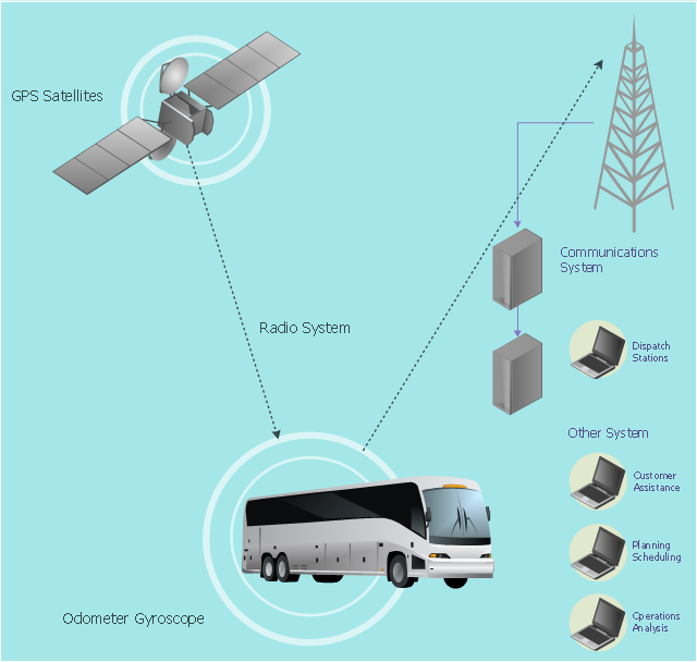
Do you like infographics and data visualization? Creating infographics is super-easy with ConceptDraw.This vehicular network diagram example was drawn on the base of picture illustrating the article "Automatic Vehicle Location: Rural Transit" from the website of the Research and Innovative Technology Administration (RITA), U.S. Department of Transportation (US DOT).
"Automatic Vehicle Location (AVL) systems calculate the real-time location of any vehicle equipped with a Global Positioning Satellite (GPS) receiver. Data are then transmitted to the transit center with use of radio or cellular communications and can be used immediately for daily operations as well as archived for further analysis.
As a stand-alone technology, an AVL system can be used to monitor on-time performance. When combined with other technologies, AVL can deliver many benefits in the areas of fleet management, service planning, safety and security, traveler information, fare payment, vehicle component monitoring, and data collection. Since the greatest benefits from AVL are achieved by combining it with other Intelligent Transportation System (ITS) technologies, AVL is most appropriate for large rural agencies with more than 30 vehicles that plan to implement a comprehensive ITS."
[pcb.its.dot.gov/ factsheets/ avl/ avlRural_ overview.asp]
The vehicular network diagram example "Automatic vehicle location" was created using the ConceptDraw PRO diagramming and vector drawing software extended with the Vehicular Networking solution from the Computer and Networks area of ConceptDraw Solution Park.
Used Solutions
- Vehicular Networking | Inter-vehicle communication systems ...
- Automatic vehicle location | Vehicular ad-hoc network | Cell Phone ...
- Automatic vehicle location | Vehicular Networking | Aerospace and ...
- ConceptDraw PRO Network Diagram Tool | Automatic vehicle ...
- Design elements - Location map | How To Draw Building Plans ...
- Automatic vehicle location | GPS operation diagram | Automatic ...
- Intelligent transportation system | Automatic vehicle location ...
- Automatic vehicle location | Vehicular Network | Vehicular ...
- Intelligent transportation system | Global vehicular network diagram ...
- Picture Of Road Map
- Bus Network Picture
- Campus Area Networks (CAN). Computer and Network Examples ...
- Images Of Network Topologies
- Logical network topology diagram | Network diagrams with ...
- Wide area network (WAN) topology. Computer and Network ...
- Elements location of a welding symbol | Location of the Migration ...
- A Plot Plan Showing The Buildings Location And Outside Electrical
- Vehicular Networking | How to Create a Vehicular Network Diagram ...
- Telecommunication networks - Vector stencils library | Independent ...
- Independent regional networks diagram | Design elements ...
- ERD | Entity Relationship Diagrams, ERD Software for Mac and Win
- Flowchart | Basic Flowchart Symbols and Meaning
- Flowchart | Flowchart Design - Symbols, Shapes, Stencils and Icons
- Flowchart | Flow Chart Symbols
- Electrical | Electrical Drawing - Wiring and Circuits Schematics
- Flowchart | Common Flowchart Symbols
- Flowchart | Common Flowchart Symbols

