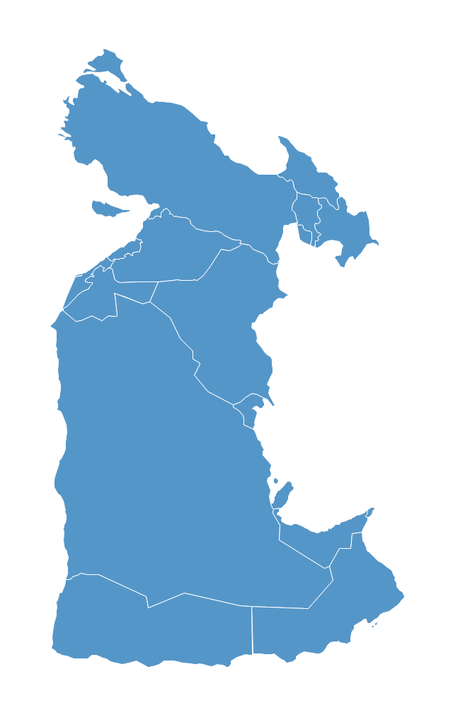
"South Asia or Southern Asia is the southern region of the Asian continent, which comprises the sub-Himalayan countries and, for some authorities, adjoining countries to the west and east. Topographically, it is dominated by the Indian Plate, which rises above sea level as northern parts of India south of the Himalayas and the Hindu Kush. South Asia is bounded on the south by the Indian Ocean and on land (clockwise, from west) by West Asia, Central Asia, East Asia, and Southeast Asia.
The current territories of Bangladesh, India, Sri Lanka and Pakistan form the core countries of South Asia, while Nepal, Bhutan and Maldives are generally included, and Afghanistan and Myanmar often added. By various deviating definitions based on often substantially different reasons, the British Indian Ocean Territory, Mauritius, Iran and the Tibet Autonomous Region are included as well. With the 7 core countries considered, South Asia is home to well over one fifth of the world's population, making it both the most populous and the most densely populated geographical region in the world. The South Asian Association for Regional Cooperation is an economic cooperation organisation in the region which was established in 1985." [South Asia. Wikipedia]
This political map sample was redesigned from the Wikimedia Commons file: South Asia (ed)update.PNG.
[commons.wikimedia.org/ wiki/ File:South_ Asia_ %28ed%29update.PNG]
The example "South Asia - Political map" was created using the ConceptDraw PRO diagramming and vector drawing software extended with the Continent Maps solution from the Maps area of ConceptDraw Solution Park.
Political map - South Asia

 Continent Maps
Continent Maps solution extends ConceptDraw DIAGRAM software with templates, samples and libraries of vector stencils for drawing the thematic maps of continents, state maps of USA and Australia.
World Continents Map

Southwest Asia region comprises countries: Turkey, Georgia, Azerbaijan, Armenia, Syria, Lebanon, Israel, Jordan, Iraq, Kuwait, Cyprus, Saudi Arabia, Bahrain, United Arab Emirates, Oman, Qatar, Yemen.
This political map sample was redesigned from the Wikimedia Commons file: Southwest-Asia-map.PNG.
[commons.wikimedia.org/ wiki/ File:Southwest-Asia-map.PNG]
The example "Southwest Asia - Political map" was created using the ConceptDraw PRO diagramming and vector drawing software extended with the Continent Maps solution from the Maps area of ConceptDraw Solution Park.
Political map - Southwest Asia
"Central Asia is the core region of the Asian continent and stretches from the Caspian Sea in the west to China in the east and from Afghanistan in the south to Russia in the north. It is also sometimes referred to as Middle Asia, and, colloquially, "the 'stans" (as the five countries generally considered to be within the region all have names ending with the Persian suffix "-stan", meaning "land of") and is within the scope of the wider Eurasian continent.
In modern contexts, all definitions of Central Asia include these five republics of the former Soviet Union: Kazakhstan ..., Kyrgyzstan ..., Tajikistan ..., Turkmenistan ..., and Uzbekistan ... Other areas sometimes included are Afghanistan, Mongolia, eastern Iran, and northwestern Pakistan, and sometimes Xinjiang and Tibet in western China, the Kashmir region of northern India and northern Pakistan, and southern Siberia in southern Russia." [Central Asia. Wikipedia]
This Central Asia political map was redesigned from Wikimedia Commons file: Central Asia - political map - 2000.svg.
[commons.wikimedia.org/ wiki/ File:Central_ Asia_ -_ political_ map_ -_ 2000.svg]
This file is licensed under the Creative Commons Attribution-Share Alike 3.0 Unported license. [creativecommons.org/ licenses/ by-sa/ 3.0/ deed.en]
The political map example "Central Asia" was drawn using the ConceptDraw PRO diagramming and vector drawing software extended with the design elements library Asia.
The political map example "Central Asia" is included in the Continent Maps solution from the Maps area of ConceptDraw Solution Park.
Political map - Central Asia

"Alphabetical list of subregions in the United Nations geoscheme for Europe.
Eastern Europe: Belarus, Bulgaria, Czech Republic, Hungary, Moldova, Poland, Romania, Russia, Slovakia, Ukraine.
Northern Europe: Åland Islands, Denmark, Estonia, Faroe Islands, Finland, Guernsey, Iceland, Ireland, Isle of Man, Jersey, Latvia, Lithuania, Norway, Svalbard and Jan Mayen, Sweden, United Kingdom.
Southern Europe: Albania, Andorra, Bosnia and Herzegovina, Croatia, Gibraltar, Greece, Italy, Malta, Montenegro, Portugal, Macedonia, San Marino, Serbia, Slovenia, Spain, Vatican City.
Western Europe: Austria, Belgium, France, Germany, Liechtenstein, Luxembourg, Monaco, Netherlands, Switzerland." [United Nations geoscheme for Europe. Wikipedia]
The example "Political map of Europe" illustrated with European state flags was created using the ConceptDraw PRO diagramming and vector drawing software extended with the Continent Maps solution from the Maps area of ConceptDraw Solution Park.
Political map - Europe

"The Andean States are a group of nations in South America that are defined by sharing a common geography (Andes mountain range) or culture such as the Quechua language and Andean cuisine which was primarily spread during the times of the Inca Empire, but also before and after it.
Politically speaking, Argentina and Chile are usually not considered part of the Andean States as they lack a strong native Andean heritage and are culturally more oriented towards Europe and they are not a members of the Andean Community of Nations (which Venezuela is in the process of leaving).
The Andes occupy the western part of South America, stretching through the following countries: Colombia, Venezuela, Ecuador, Peru, Bolivia, Argentina (not considered to be -geopolitically- an Andean State), Chile (not considered to be -geopolitically- an Andean State)." [Andean states. Wikipedia]
"Southern Cone (Spanish: Cono Sur, Portuguese: Cone Sul) is a geographic region composed of the southernmost areas of South America, south of and around the Tropic of Capricorn. Traditionally, it covers Argentina, Chile and Uruguay, bounded on the west by the Pacific Ocean, and south to the junction between the Pacific and Atlantic Oceans, which is the closest continental area of Antarctica (1000 km). In terms of social and political geography, the Southern Cone comprises Argentina, Chile, Paraguay, Uruguay, Southern Brazil and the Brazilian state of São Paulo.
High life expectancy, the highest Human Development Index of Latin America, high standard of living, significant participation in the global markets and the emerging economy of its members make the Southern Cone the most prosperous macro-region in South America." [Southern Cone. Wikipedia]
Eastern South America (Brazil). "Brazil Listeni/ brəˈzɪl/ (Portuguese: Brasil, IPA: [bɾaˈziw]), officially the Federative Republic of Brazil (Portuguese: República Federativa do Brasil, About this sound listen (help·info)), is the largest country in both South America and the Latin American region. It is the world's fifth largest country, both by geographical area and by population. It is the largest Portuguese-speaking country in the world, and the only one in the Americas. Bounded by the Atlantic Ocean on the east, Brazil has a coastline of 7,491 km (4,655 mi). It is bordered on the north by Venezuela, Guyana, Suriname and the French overseas region of French Guiana; on the northwest by Colombia; on the west by Bolivia and Peru; on the southwest by Argentina and Paraguay and on the south by Uruguay. Numerous archipelagos form part of Brazilian territory, such as Fernando de Noronha, Rocas Atoll, Saint Peter and Paul Rocks, and Trindade and Martim Vaz. It borders all other South American countries except Ecuador and Chile and occupies 47 percent of the continent of South America." [Brazil. Wikipedia]
"The Guianas, sometimes called by the Spanish loan-word Guayanas (Las Guayanas) refers to a region in north-eastern South America which includes the following three territories:
(1) French Guiana, an overseas department of France,
(2) Guyana, known as British Guiana from 1831 until 1966, after the colonies of Berbice, Essequibo, and Demerara, taken from the Netherlands in 1814, were merged into a single colony,
(3) Suriname, until 1814 a part of Dutch Guiana, together with Berbice, Essequibo and Demerara." [The Guianas. Wikipedia]
This political map sample was redesigned from the Wikimedia Commons file: South America Color-coded Regions.png. [commons.wikimedia.org/ wiki/ File:South_ America_ Color-coded_ Regions.png]
This file is licensed under the Creative Commons Attribution-Share Alike 3.0 Unported license. [creativecommons.org/ licenses/ by-sa/ 3.0/ deed.en]
The example "South America regions - Political map" was created using the ConceptDraw PRO diagramming and vector drawing software extended with the Continent Maps solution from the Maps area of ConceptDraw Solution Park.
Political map - South America regions

"The Middle East (also called Mid East in US usage) is a region that roughly encompasses a majority of Western Asia (excluding the Caucasus) and Egypt. The term is used as a synonym for Near East, in opposition to Far East. The corresponding adjective is Middle Eastern and the derived noun is Middle Easterner. Arabs, Persians, and Turks constitute the largest ethnic groups in the region by population, while Kurds, Azeris, Copts, Jews, Assyrians, Maronites, Circassians, Somalis, Armenians, Druze and other denominations form a significant minority. ... The following countries are included within the Middle East... : Bahrain, Cyprus, Egypt, Iran, Iraq, Israel, Jordan, Kuwait, Lebanon, Northern Cyprus, Oman, Palestine, Qatar, Saudi Arabia, Syria, Turkey, United Arab Emirates, Yemen.
" [Middle East. Wikipedia]
This political map sample was redesigned from the Wikimedia Commons file: Middle east map.png. [commons.wikimedia.org/ wiki/ File:Middle_ east_ map.png]
The example "Middle East - Political map" was created using the ConceptDraw PRO diagramming and vector drawing software extended with the Continent Maps solution from the Maps area of ConceptDraw Solution Park.
Political map - Middle East

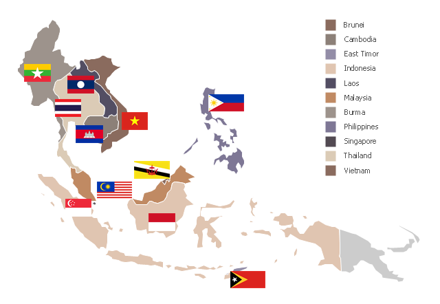
"Southeast Asia or Southeastern Asia is a subregion of Asia, consisting of the countries that are geographically south of China, east of India, west of New Guinea and north of Australia. The region lies near the intersection of geological plates, with heavy seismic and volcanic activity. Southeast Asia consists of two geographic regions:
(1) Maritime Southeast Asia, comprising Philippines, East Malaysia, East Timor, Indonesia, Brunei, and Singapore.
(2) Mainland Southeast Asia, also known as Indochina, comprising Cambodia, Laos, Myanmar (Burma), Thailand, West Malaysia and Vietnam." [Southeast Asia. Wikipedia]
This political map sample was redesigned from the Wikimedia Commons file: Suresteasia324.jpg. [commons.wikimedia.org/ wiki/ File:Suresteasia324.jpg]
This file is licensed under the Creative Commons Attribution-Share Alike 3.0 Unported license. [creativecommons.org/ licenses/ by-sa/ 3.0/ deed.en]
The example "Southeast Asia - Political map" was created using the ConceptDraw PRO diagramming and vector drawing software extended with the Continent Maps solution from the Maps area of ConceptDraw Solution Park.
Political map - Southeast Asia
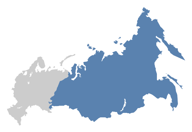
"North Asia or Northern Asia is a subregion of Asia, consisting of the Asian portion of Russia – area on the east of Ural Mountains." [North Asia. Wikipedia]
This political map sample was redesigned from the Wikimedia Commons file: Location-Asia-UNsubregions.png. [commons.wikimedia.org/ wiki/ File:Location-Asia-UNsubregions.png]
The example "North Asia - Political map" was created using the ConceptDraw PRO diagramming and vector drawing software extended with the Continent Maps solution from the Maps area of ConceptDraw Solution Park.
Political map - North Asia
"Central America ... is the central geographic region of the Americas. It is the southernmost, isthmian portion of the North American continent, which connects with South America on the southeast. When considered part of the unified continental model, it is considered a subcontinent. Central America consists of seven countries: Belize, Costa Rica, El Salvador, Guatemala, Honduras, Nicaragua, and Panama. Central America is part of the Mesoamerican biodiversity hotspot, which extends from northern Guatemala through central Panama. It is bordered by Mexico to the north, the Caribbean Sea to the east, the North Pacific Ocean to the west, and Colombia to the south-east, which is also the most southern point of North America." [Central America. Wikipedia]
This example Political map of Central America was redesigned from Wikimedia Commons file: Map of Central America.png. [commons.wikimedia.org/ wiki/ File:Map_ of_ Central_ America.png]
This file is licensed under the Creative Commons Attribution-Share Alike 3.0 Unported license. [creativecommons.org/ licenses/ by-sa/ 3.0/ deed.en]
The example "Political map of Central America" was created using the ConceptDraw PRO diagramming and vector drawing software extended with the Continent Maps solution from the Maps area of ConceptDraw Solution Park.
Political map - Central America

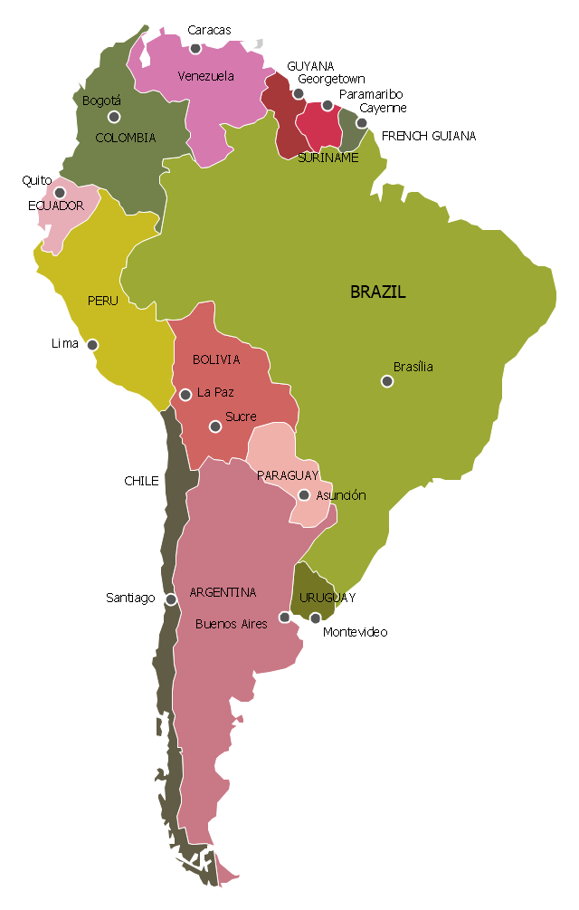
"South America is a continent located in the Western Hemisphere, mostly in the Southern Hemisphere, with a relatively small portion in the Northern Hemisphere. It can also be considered as a subcontinent of the Americas.
It is bordered on the west by the Pacific Ocean and on the north and east by the Atlantic Ocean; North America and the Caribbean Sea lie to the northwest. It includes twelve sovereign states – Argentina, Bolivia, Brazil, Chile, Colombia, Ecuador, Guyana, Paraguay, Peru, Suriname, Uruguay, and Venezuela – and two non-sovereign areas – French Guiana, an overseas department of France, and the Falkland Islands, a British Overseas Territory (though disputed by Argentina). In addition to this, the ABC islands of the Netherlands may also be considered part of South America. ... Countries and territories: Argentina, Bolivia, Brazil, Chile, Colombia, Ecuador, Falkland Islands (United Kingdom), French Guiana (France), Guyana, Paraguay, Peru, South Georgia and the South Sandwich Islands (United Kingdom), Suriname, Uruguay, Venezuela." [South America. Wikipedia]
This political map sample was redesigned from the Wikimedia Commons file: Map of South America.svg. [commons.wikimedia.org/ wiki/ File:Map_ of_ South_ America.svg]
This file is licensed under the Creative Commons Attribution-Share Alike 3.0 Unported license. [creativecommons.org/ licenses/ by-sa/ 3.0/ deed.en]
The example "South America - Political map" was created using the ConceptDraw PRO diagramming and vector drawing software extended with the Continent Maps solution from the Maps area of ConceptDraw Solution Park.
Political map - South America
This political map of Canada exhibits its ten provinces and three territories, and their capitals.
"Canada is a country in North America consisting of 10 provinces and 3 territories. Located in the northern part of the continent, it extends from the Atlantic to the Pacific and northward into the Arctic Ocean. At 9.98 million square kilometers in total, Canada is the world's second-largest country by total area, and its common border with the United States is the world's longest land border shared by the same two countries." [Canada. Wikipedia]
This Canada political map was redesigned from Wikipedia file Map Canada political 2.png. [commons.wikimedia.org/ wiki/ File:Map_ Canada_ political_ 2.png]
The example "Canada political map" was created using the ConceptDraw PRO diagramming and vector drawing software extended with the Continent Maps solution from the Maps area of ConceptDraw Solution Park.
Political map - Canada

This Germany political map example was created on the base of Wikimedia Commons file: Deutschland politisch bunt.png. [commons.wikimedia.org/ wiki/ File:Deutschland_ politisch_ bunt.png]
This file is licensed under the Creative Commons Attribution-Share Alike 2.5 Generic license. [creativecommons.org/ licenses/ by-sa/ 2.5/ deed.en]
"Germany (German: Deutschland), officially the Federal Republic of Germany (German: Bundesrepublik Deutschland), is a federal parliamentary republic in West-Central Europe. It includes 16 constituent states and covers an area of 357,021 square kilometres (137,847 sq mi) with a largely temperate seasonal climate. Its capital and largest city is Berlin. With about 81.5 million inhabitants, Germany is the most populous member state in the European Union. After the United States, it is the second most popular migration destination in the world." [Germany. Wikipedia]
The example "Political map of Germany" was designed using the ConceptDraw PRO software extended with the Map of Germany solution from the Maps area of ConceptDraw Solution Park.
States and cities map example
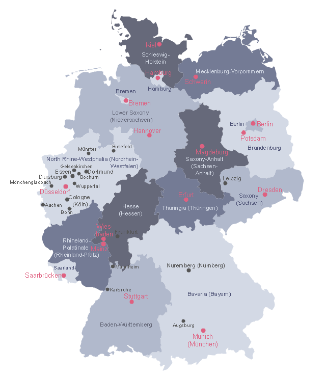
Map of Germany

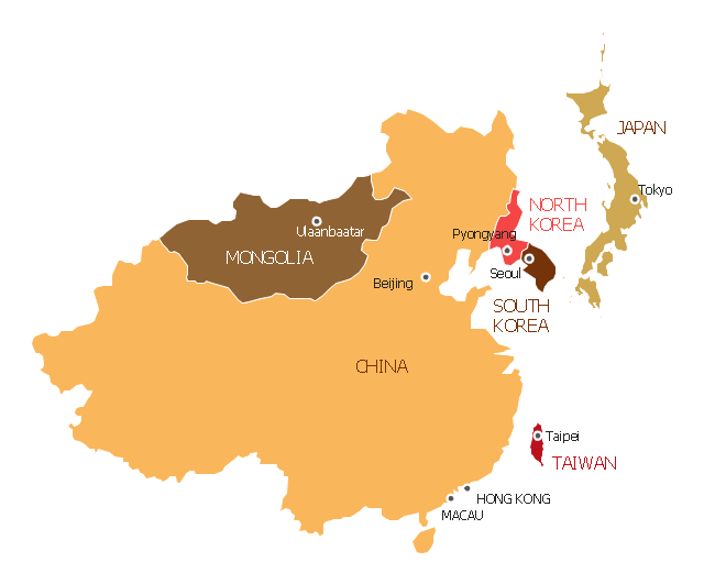
"East Asia or Eastern Asia (the latter form preferred solely by the United Nations) is a subregion of Asia that can be defined in either geographical or cultural terms. ...
The UN subregion of Eastern Asia and other common definitions of East Asia contain the entirety of the People's Republic of China, Japan, North Korea, South Korea, Mongolia and Taiwan.
Culturally, China, Japan, Korea, Taiwan, and Vietnam are commonly seen as being encompassed by cultural East Asia." [East Asia. Wikipedia]
This East Asia map was redesigned from Wikimedia Commons file: Map of East Asia.png. [commons.wikimedia.org/ wiki/ File:Map_ of_ East_ Asia.png]
This file is licensed under the Creative Commons Attribution-Share Alike 3.0 Unported license. [creativecommons.org/ licenses/ by-sa/ 3.0/ deed.en]
The example "East Asia - Political map" was created using the ConceptDraw PRO diagramming and vector drawing software extended with the Continent Maps solution from the Maps area of ConceptDraw Solution Park.
Political map - Eastern Asia
A map showing European membership of the EU and NATO.
"The European Union (EU) is an economic and political union of 28 member states that are located primarily in Europe.
The EU operates through a system of supranational independent institutions and intergovernmental negotiated decisions by the member states. Institutions of the EU include the European Commission, the Council of the European Union, the European Council, the Court of Justice of the European Union, the European Central Bank, the Court of Auditors, and the European Parliament. The European Parliament is elected every five years by EU citizens. The EU's de facto capital is Brussels." [European Union. Wikipedia]
"The principal military alliance in Europe remains NATO, which includes 21 of all EU member states as well as other non-EU European countries, Turkey, the United States and Canada." [Military of the European Union. Wikipedia]
"The North Atlantic Treaty Organization (NATO), also called the (North) Atlantic Alliance, is an intergovernmental military alliance based on the North Atlantic Treaty which was signed on 4 April 1949. The organization constitutes a system of collective defence whereby its member states agree to mutual defense in response to an attack by any external party. NATO's headquarters are in Brussels, Belgium, one of the 28 member states across North America and Europe, the newest of which, Albania and Croatia, joined in April 2009." [NATO. Wikipedia]
This Europe map example was redesigned using the ConceptDraw PRO diagramming and vector drawing software from the Wikimedia Commons file: EU and NATO.svg.
[commons.wikimedia.org/ wiki/ File:EU_ and_ NATO.svg]
The Europe political map example "European membership of the EU and NATO map" is included in the Continent Maps solution from the Maps area of ConceptDraw Solution Park.
Political map - EU and NATO

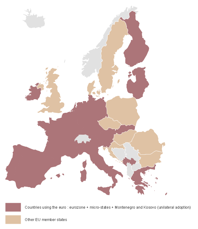
This Germany political map example was created on the base of Wikimedia Commons file: BlueEurozone.svg. [commons.wikimedia.org/ wiki/ File:BlueEurozone.svg]
"The eurozone, officially called the euro area, is a monetary union of 19 of the 28 European Union (EU) member states which have adopted the euro (€) as their common currency and sole legal tender. The other nine members of the European Union continue to use their own national currencies.
The eurozone consists of Austria, Belgium, Cyprus, Estonia, Finland, France, Germany, Greece, Ireland, Italy, Latvia, Lithuania, Luxembourg, Malta, the Netherlands, Portugal, Slovakia, Slovenia, and Spain." [Eurozone. Wikipedia]
The political map example "Map of Germany in Eurozone" was designed using the ConceptDraw PRO software extended with the Map of Germany solution from the Maps area of ConceptDraw Solution Park.
Political map example
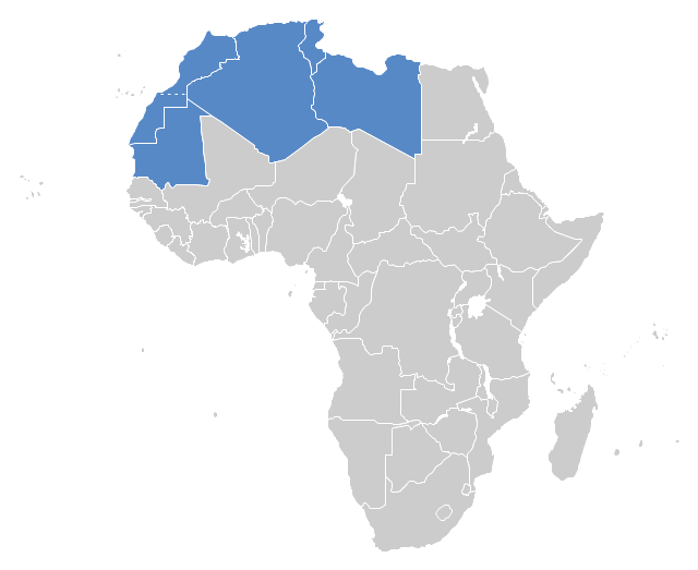
"The Maghreb is usually defined as much or most of the region of Northwest Africa, west of Egypt. The traditional definition as being the region including the Atlas Mountains and the coastal plains of Morocco, Algeria, Tunisia, and Libya, was later superseded, especially since the 1989 formation of the Arab Maghreb Union, by the inclusion of Mauritania and of the disputed territory of Western Sahara (mostly controlled by Morocco)." [Maghreb. Wikipedia]
This Maghreb map example was redesigned using ConceptDraw PRO diagramming and vector drawing software from the Wikimedia Commons file: Maghreb.png.
[commons.wikimedia.org/ wiki/ File:Maghreb.png]
The political map example "Maghreb countries" is included in the Continent Map solution from Maps area of ConceptDraw Solution Park.
Political map - Maghreb countries
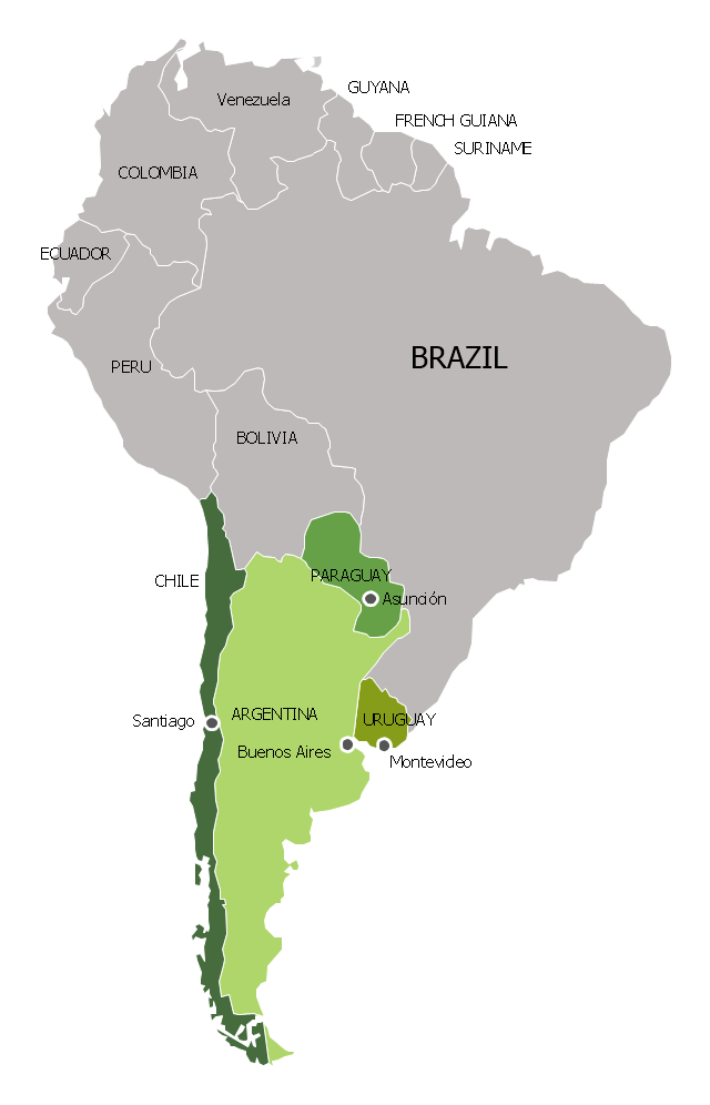
"Southern Cone (Spanish: Cono Sur, Portuguese: Cone Sul) is a geographic region composed of the southernmost areas of South America, south of and around the Tropic of Capricorn. Traditionally, it covers Argentina, Chile and Uruguay, bounded on the west by the Pacific Ocean, and south to the junction between the Pacific and Atlantic Oceans, which is the closest continental area of Antarctica (1000 km). In terms of social and political geography, the Southern Cone comprises Argentina, Chile, Paraguay, Uruguay, Southern Brazil and the Brazilian state of São Paulo.
High life expectancy, the highest Human Development Index of Latin America, high standard of living, significant participation in the global markets and the emerging economy of its members make the Southern Cone the most prosperous macro-region in South America." [Southern Cone. Wikipedia]
This political map sample was redesigned from the Wikimedia Commons file: Map of South America (Cono sud).png. [commons.wikimedia.org/ wiki/ File:Map_ of_ South_ America_ (Cono_ sud).png]
This file is licensed under the Creative Commons Attribution-Share Alike 3.0 Unported license. [creativecommons.org/ licenses/ by-sa/ 3.0/ deed.en]
The example "Southern Cone - Political map" was created using the ConceptDraw PRO diagramming and vector drawing software extended with the Continent Maps solution from the Maps area of ConceptDraw Solution Park.
Political map - Southern Cone
- Middle East - Political map | Political map of Germany | Map of ...
- Middle East - Political map | Central Asia - Political map | Continent ...
- World Continents Map | Political map of Europe | European ...
- South Asia Map Example
- Maghreb countries - Political map | Continent Maps | Geo Map ...
- Central Asia - Political map | Political map of Asia | Southwest Asia ...
- North Asia - Political map | Southeast Asia - Political map | North ...
- Southwest Asia - Political map
- Central Asia - Political map | North Asia - Political map | South Asia ...
- South America regions - Political map | Continent Maps | Geo Map ...
- Maghreb countries - Political map | Map Of The Maghreb
- Canada political map | Canada - Vector stencils library | Canada ...
- Continent Maps | Geo Mapping Software Examples - World Map ...
- Geo Map - Asia | Central Asia - Political map | Continent Maps ...
- How To Do A Mind Map In PowerPoint | South Asia - Political map ...
- South Asia - Political map | How To Do A Mind Map In PowerPoint ...
- East Africa - Political map | West Africa countries | Geo Map - Africa ...
- Central Asia - Political map | Geo Map — Asia | South Asia - Political ...
- European membership of the EU and NATO map | Political map of ...
- Middle East - Political map | South America - Political map | Central ...
- ERD | Entity Relationship Diagrams, ERD Software for Mac and Win
- Flowchart | Basic Flowchart Symbols and Meaning
- Flowchart | Flowchart Design - Symbols, Shapes, Stencils and Icons
- Flowchart | Flow Chart Symbols
- Electrical | Electrical Drawing - Wiring and Circuits Schematics
- Flowchart | Common Flowchart Symbols
- Flowchart | Common Flowchart Symbols