Geo Map — United States of America Map

ConceptDraw is idea to draw the geological map of the United States of America from the pre-designed vector geo map shapes.
Each map is scaled, with the option to add further levels of detail - county borders, their names, capitals and major cities can be shown or hidden using the action menu for each state map. ConceptDraw DIAGRAM gives you full control over map size, shading, color fills and alignment.
Use the Continent Maps solution for easy drawing professional looking geological maps, thematic maps, geospatial infographics and vector illustrations for your business documents, presentations and websites.
Geo Map of Americas

ConceptDraw is idea to draw the geological maps of America from the pre-designed vector geo map shapes and vector images map of america.
Use Continent Maps solution from the Maps area of ConceptDraw Solution Park to draw thematic maps, geospatial infographics and vector illustrations for your business documents, presentations and websites.
Geo Map — USA — Washington

The vector stencils library Washington contains contours for ConceptDraw DIAGRAM diagramming and vector drawing software. This library is contained in the Continent Maps solution from Maps area of ConceptDraw Solution Park.
 Continent Maps
Continent Maps solution extends ConceptDraw DIAGRAM software with templates, samples and libraries of vector stencils for drawing the thematic maps of continents, state maps of USA and Australia.
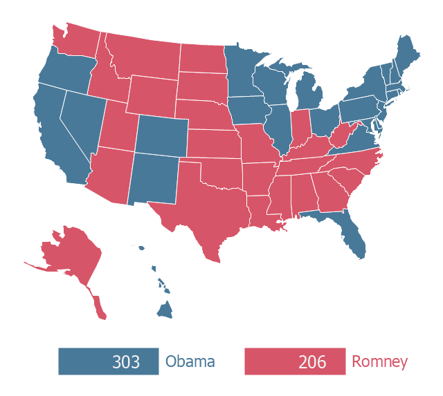
"The election of the President and the Vice President of the United States is an indirect vote in which citizens cast ballots for a slate of members of the U.S. Electoral College; these electors in turn directly elect the President and Vice President. Presidential elections occur quadrennially (the count beginning with the year 1792) on Election Day, the Tuesday between November 2 and 8, coinciding with the general elections of various other federal, states and local races. The most recent was the 2012 election, held on November 6. The next election will be the 2016 election, which will be held on November 8, 2016." [United States presidential election. Wikipedia]
This U.S.A. thematic map was redesigned from Wikipedia file: 2012 U.S. Presidential Election Results.jpg. [commons.wikimedia.org/ wiki/ File:2012_ U.S._ Presidential_ Election_ Results.jpg]
This file is licensed under the Creative Commons Attribution-Share Alike 3.0 Unported license.
[creativecommons.org/ licenses/ by-sa/ 3.0/ deed.en]
This U.S. thematic map example was created using ConceptDraw PRO diagramming and vector drawing software extended with Continent Maps solution from Maps area of ConceptDraw Solution Park.
Thematic map - 2012 US presidential election
- Geo Map - United States of America Map | 2012 United States ...
- Geo Map - United States of America Map | Map of USA with state ...
- Demonstrating Results | How To Use Skype for Business | Sochi ...
- London election results - Divided bar diagram | 2012 United States ...
- Thematic map - 2012 US presidential election
- F&B | Websites interlinking to illustrate PageRank | Chemical ...
- ERD | Entity Relationship Diagrams, ERD Software for Mac and Win
- Flowchart | Basic Flowchart Symbols and Meaning
- Flowchart | Flowchart Design - Symbols, Shapes, Stencils and Icons
- Flowchart | Flow Chart Symbols
- Electrical | Electrical Drawing - Wiring and Circuits Schematics
- Flowchart | Common Flowchart Symbols
- Flowchart | Common Flowchart Symbols