Geo Map - Australia - New Zealand

Map Australia

HelpDesk
How to Draw Maps of Australia Using ConceptDraw PRO

Geo Map - Australia - Victoria

Geo Map - Australia - South Australia

 Australia Map
For graphic artists creating accurate maps of Australia. The Australia Map solution - allows designers to map Australia for their needs, offers a collection of scalable graphics representing the political geography of Australia, split into distinct state
Map of Australia

Australia Map

Geo Map - Australia

Geo Map - Australia - Nothern Territory

Geo Map - Australia - Tasmania

Geo Map - Australia - New South Wales

Geo Map - Australia - Queensland

Geo Map - Australia - Western Australia

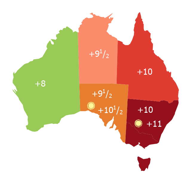
Map of Australia depicting time zones offsets from UTC by state (including daylight saving).
"Time in Australia uses more than three time zones, including Australian Western Standard Time (AWST; UTC+08:00), Australian Central Standard Time (ACST; UTC+09:30), and Australian Eastern Standard Time (AEST; UTC+10:00). Time is regulated by the individual state governments, some of which observe daylight saving time (DST). Australia's external territories observe different time zones." [Time in Australia. Wikipedia]
This thematic map was redesigned from Wikipedia file: Australia states timezones.png. [commons.wikimedia.org/ wiki/ File:Australia-states-timezones.png]
This file is licensed under the Creative Commons Attribution-Share Alike 3.0 Unported license.
[creativecommons.org/ licenses/ by-sa/ 3.0/ deed.en]
The thematic map example "Australia states time zones" was created using the ConceptDraw PRO diagramming and vector drawing software extended with the Continent Maps solution from the Maps area of ConceptDraw Solution Park.
Thematic map - Australia states time zones
- Australia Map | Geo Map - Australia - South Australia | How to Draw ...
- Australia Map | How to Draw Maps of Australia Using ConceptDraw ...
- Map Australia | Geo Map - Asia - Israel | Competitor Analysis | Name ...
- Geo Map - Australia - New South Wales | 7 Continents Map ...
- Geo Map - Australia | Continent Maps | Design elements - Australia ...
- Australia Map Example
- Territory Mapping Software Free Australia
- Western Australia Map
- Geo Map - Australia - Tasmania
- How to Draw Maps of Australia Using ConceptDraw PRO | Geo Map ...
- How to Draw Maps of Australia Using ConceptDraw PRO | Map ...
- Australia states time zones - Thematic map
- Geo Map - Australia - New Zealand
- Geo Map - Canada - Northwest Territories | Geo Map - Australia ...
- Australia states time zones - Thematic map | 7 Continents Map ...
- Map of median household income in Australia | Continent Maps ...
- Australia and New Zealand - Vector stencils library | Management ...
- Australia map - Template | Geo Map - Australia - New Zealand | Geo ...
- Australia map - Template | Maps | Continent Maps | Australia Map ...
- Geo Map - Australia - Nothern Territory | How to Draw Maps of ...
- ERD | Entity Relationship Diagrams, ERD Software for Mac and Win
- Flowchart | Basic Flowchart Symbols and Meaning
- Flowchart | Flowchart Design - Symbols, Shapes, Stencils and Icons
- Flowchart | Flow Chart Symbols
- Electrical | Electrical Drawing - Wiring and Circuits Schematics
- Flowchart | Common Flowchart Symbols
- Flowchart | Common Flowchart Symbols