Map of UK — Scotland

How to design the Map of UK fast and easy? It is incredibly convenient to use special software. ConceptDraw PRO diagramming and vector drawing software offers the Map of UK Solution from the Maps Area of ConceptDraw Solution Park specially developed to make easier drawing the maps of UK counties, various UK related thematic maps and cartograms on their base.
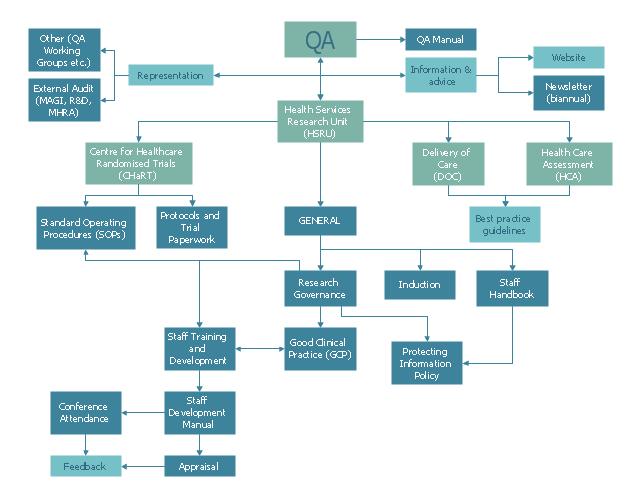
This example was created on the base of QA flowchart from the website of the Health Services Research Unit (HSRU), University of Aberdeen. [abdn.ac.uk/ hsru/ research/ quality/ qa-documents/ ]
"Quality assurance (QA) is a way of preventing mistakes or defects in manufactured products and avoiding problems when delivering solutions or services to customers...
QA is very important in the medical field because it helps to identify the standards of medical equipments and services. Hospitals and laboratories make use of external agencies in order to ensure standards for equipment such as X-ray machines, Diagnostic Radiology and AERB." [Quality assurance. Wikipedia]
The example "Process flowchart - QA processes in HSRU" was created using the ConceptDraw PRO software extended with the Seven Basic Tools of Quality solution from the Quality area of ConceptDraw Solution Park.
Flow chart example
Map of Scotland

ConceptDraw PRO diagramming and vector drawing software extended with powerful Map of UK Solution from the Maps Area of ConceptDraw Solution Park is the best for drawing various kinds of United Kingdom maps, map of Scotland, map of England, map of Wales, Northern Ireland map, thematic UK maps of any detailing and geospatial infographics.
United Kingdom Cities

How to design the Map of UK fast and easy? It is incredibly convenient to use special software. ConceptDraw PRO diagramming and vector drawing software offers the Map of UK Solution from the Maps Area of ConceptDraw Solution Park specially developed to make easier drawing the maps of UK counties, various UK related thematic maps and cartograms on their base.
Map of UK — Great Britain Cities

How to design the Map of UK fast and easy? It is incredibly convenient to use special software. ConceptDraw PRO diagramming and vector drawing software offers the Map of UK Solution from the Maps Area of ConceptDraw Solution Park specially developed to make easier drawing the maps of UK counties, various UK related thematic maps and cartograms on their base.
- Aberdeen
- Process flowchart - QA processes in HSRU | Laboratory Epuiments
- Basic Audit Flowchart. Flowchart Examples | Solving quadratic ...
- Process Flowchart | Example Process Flow Chart | Example Process ...
- Process Flowchart | TQM Software — Build Professional TQM ...
- Process Flowchart | HR management process - Flowchart | Process ...
- Flowchart | Example Process Flow | Basic Flowchart Symbols and ...
- Flowchart | Website launch - Flowchart | Example Process Flow ...
- Equipment Type Flow Process Chart Example
- Why Flowchart Important to Accounting Information System? | Basic ...
- Copying Service Process Flowchart. Flowchart Examples | Process ...
- Laboratory equipment - Vector stencils library | Design elements ...
- Sales Process Flowchart. Flowchart Examples | Flow chart Example ...
- Process Flowchart | Copying Service Process Flowchart. Flowchart ...
- Basic Workflow Examples | Floor Plans | Tools - Vector stencils ...
- Cable TV - Vector stencils library | Power sources - Vector stencils ...
- ERD | Entity Relationship Diagrams, ERD Software for Mac and Win
- Flowchart | Basic Flowchart Symbols and Meaning
- Flowchart | Flowchart Design - Symbols, Shapes, Stencils and Icons
- Flowchart | Flow Chart Symbols
- Electrical | Electrical Drawing - Wiring and Circuits Schematics
- Flowchart | Common Flowchart Symbols
- Flowchart | Common Flowchart Symbols