USA Map
Usually designing of maps, including the USA Map is a quite complex, long and labour-intensive process. But now we have an excellent possibility to make it easier with ConceptDraw DIAGRAM diagramming and vector drawing software extended with powerful USA Maps Solution from the Maps Area of ConceptDraw Solution Park.

Example 1. USA Map - New York Counties
USA Maps Solution includes the extensive set of drawing tools and 9 libraries with 52 ready-to-use vector map objects representing all USA states.
The objects from these libraries, and also predesigned template and collection of samples offered in ConceptDraw STORE will allow you instantly draw the USA Map and various thematic USA Maps. Thanks to the ConceptDraw DIAGRAM software we always have excellent result - professional looking maps which can be successfully used on various conferences and presentations, in publications, reference guides and infographics.
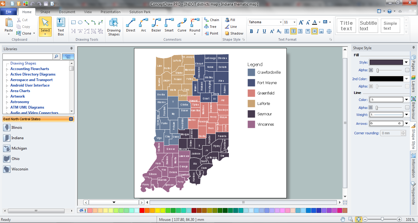
Example 2. Indiana Thematic Map in ConceptDraw DIAGRAM /p>
Use bright colors to make your map more attractive, highlight by colors the names of large cities, capitals. Sometimes can be useful to highlight several county areas on the map, ConceptDraw DIAGRAM gives you this possibility too.
You can also add the legend to make your map more informative and comprehensible.

Example 3. USA Map - Texas Counties Map
This sample was created in ConceptDraw DIAGRAM software using the tools of the USA Maps solution. It shows the part of USA Map - detailed Texas counties map. An experienced user spent 20 minutes creating this sample.
Use the USA Maps solution for ConceptDraw DIAGRAM software to design your own USA Map quick, easy and effective, and then successfully use it in your life or work activity.
All source documents are vector graphic documents. They are available for reviewing, modifying, or converting to a variety of formats (PDF file, MS PowerPoint, MS Visio, and many other graphic formats) from the ConceptDraw STORE. The USA Maps Solution is available for all ConceptDraw DIAGRAM or later users.
NINE RELATED HOW TO's:
New Mexico is a state located in the southwest and western regions of the United States.
The vector stencils library New Mexico contains contours for ConceptDraw DIAGRAM diagramming and vector drawing software. This library is contained in the Continent Maps solution from Maps area of ConceptDraw Solution Park.
Picture: Geo Map - USA - New Mexico
Related Solution:
A list of parameters on which networks differ is very long. A large network with a range up to 50 kilometers is called metropolitan area network (MAN), and this type of network can include several local area networks. Metropolitan networks in their turn connect into global area networks.
Here you will see a Metropolitan Area Network (MAN). This is an extensive network which occupies a large territory including a few buildings or even the whole city. The space of the MAN is bigger than LAN, but lower than WAN. MAN comprise a lot of communication equipment and delivers the Internet connection to the LANs in the city area. Computer and Networks solution for ConceptDraw DIAGRAM provides a set of libraries with ready-to-use vector objects to design various kinds of computer networks.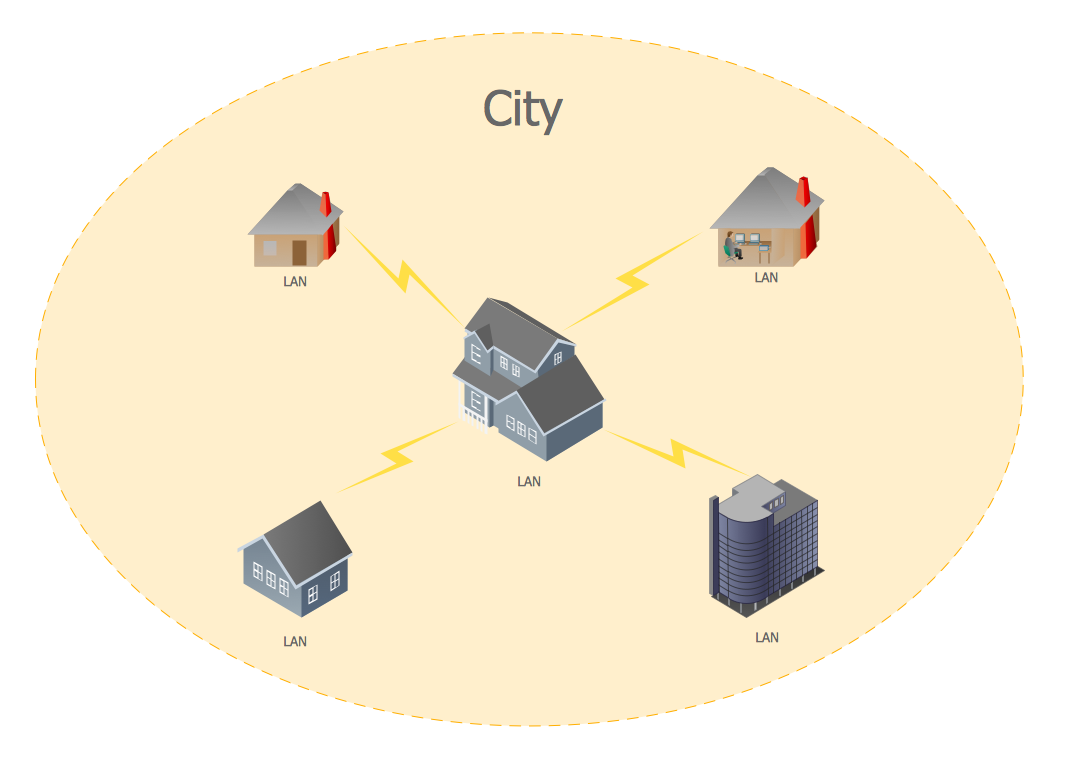
Picture: Metropolitan area networks (MAN). Computer and Network Examples
Related Solution:
Peru, officially the Republic of Peru, is a country in western South America.
The history of Peru goes back to the distant past and its divided into several main stages. Geography of Peru is also diverse - there is a desert, as well as the ocean coast, and of course the mountain ranges.
The Continent Maps solution from Maps area of ConceptDraw Solution Park provides stencil library Peru, which is made up of well-designed vector shapes delivering easy experience in creating diagrams with ConceptDraw DIAGRAM software.
All ConceptDraw DIAGRAM documents are vector graphic files and are available for reviewing, modifying, and converting to a variety of formats: image, HTML, PDF file, MS PowerPoint Presentation, Adobe Flash, MS Visio (.VDX,.VSDX).
Picture: Geo Map — South America — Peru
Related Solution:
Alaska is a U.S. state situated in the northwest extremity of the North American continent.
The vector stencils library Alaska contains contours for ConceptDraw DIAGRAM diagramming and vector drawing software. This library is contained in the Continent Maps solution from Maps area of ConceptDraw Solution Park.
Picture: Geo Map — USA — Alaska
Related Solution:
New Hampshire is a state in the New England region of the northeastern United States of America. The state was named after the southern English county of Hampshire.
The vector stencils library New Hampshire contains contours for ConceptDraw DIAGRAM diagramming and vector drawing software. This library is contained in the Continent Maps solution from Maps area of ConceptDraw Solution Park.
Picture: Geo Map - USA - New Hampshire
Related Solution:
Mississippi is a U.S. state located in the Southern United States.
The vector stencils library Mississippi contains contours for ConceptDraw DIAGRAM diagramming and vector drawing software. This library is contained in the Continent Maps solution from Maps area of ConceptDraw Solution Park.
Picture: Geo Map — USA — Mississippi
Related Solution:
The United Kingdom of Great Britain and Northern Ireland, commonly known as the United Kingdom (UK) or Britain, is a sovereign state in Europe.
How to design the Map of UK fast and easy? It is incredibly convenient to use special software. ConceptDraw DIAGRAM diagramming and vector drawing software offers the Map of UK Solution from the Maps Area of ConceptDraw Solution Park specially developed to make easier drawing the maps of UK counties, various UK related thematic maps and cartograms on their base.
Picture: Map of UK
Related Solution:
North Dakota is the 39th state of the United States, having been admitted to the union on November 2, 1889.
The vector stencils library North Dakota contains contours for ConceptDraw DIAGRAM diagramming and vector drawing software. This library is contained in the Continent Maps solution from Maps area of ConceptDraw Solution Park.
Picture: Geo Map - USA - North Dakota
Related Solution:
Indiana is a U.S. state located in the midwestern and Great Lakes regions of North America.
The vector stencils library Indiana contains contours for ConceptDraw DIAGRAM diagramming and vector drawing software. This library is contained in the Continent Maps solution from Maps area of ConceptDraw Solution Park.
Picture: Geo Map - USA - Indiana
Related Solution:


